geo.wikisort.org - Mountains
Methana (Greek: Μέθανα) is a town and a former municipality on the Peloponnese peninsula, Greece. Since the 2011 local government reform it is part of the municipality Troizinia-Methana, of which it is a municipal unit.[2] The municipal unit has an area of 50.161 km2.[3]
Methana
Μέθανα | |
|---|---|
 Town of Methana | |
 Methana Location within the regional unit 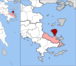 | |
| Coordinates: 37°34′N 23°23′E | |
| Country | Greece |
| Administrative region | Attica |
| Regional unit | Islands |
| Municipality | Troizinia-Methana |
| Districts | 4 |
| • Municipal unit | 50.161 km2 (19.367 sq mi) |
| Elevation | 18 m (59 ft) |
| Population (2011)[1] | |
| • Municipal unit | 1,657 |
| • Municipal unit density | 33/km2 (86/sq mi) |
| Time zone | UTC+2 (EET) |
| • Summer (DST) | UTC+3 (EEST) |
| Postal code | 180 30 |
| Area code(s) | 22980 |
| Website | www.methana.gr |
Methana is situated on a volcanic (the Methana Volcano) peninsula, attached to the Peloponnese. Administratively, it belongs to the Attica region. The town (pop. 892 in 2011) is located north of the road connecting to the rest of the Peloponnese and Galatas. The highest point is 740 metres (2,428 feet) (Helona Mountain). The municipal unit has a land area of 50.161 square kilometres (19.367 square miles) and a population of 1,657 inhabitants at the 2011 census. The largest settlements besides the town of Methana are Vathý (pop. 129), Megalochóri (115), Kounoupítsa (75), Kypséli (47), Ágioi Theódoroi (45), and Dritsaíika (205)
Subdivisions
The municipal unit Methana is subdivided into the following communities (constituent villages in brackets):
- Kounoupitsa (Kounoupitsa, Agios Georgios, Agios Nikolaos, Makrylongos, Palaia Loutra)
- Kypseli (Kypseli, Agioi Theodoroi)
- Loutropoli Methanon (Methana, Dritsaiika)
- Megalochori (Megalochori, Vathy, Kaimeni Chora, Megalo Potami)
Historical population
| Year | Community population | Municipal unit population |
|---|---|---|
| 1981 | 1,035 | - |
| 1991 | 1,054 | 2,056 |
| 2001 | 1,148 | 2,057 |
| 2011 | 1,097 | 1,657 |
Half of the entire peninsula's population lives in Methana town.
Volcanic activity
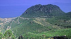
The peninsula is entirely of volcanic origin and contains over 30 volcanic eruption centers. The last volcanic eruption occurred near present-day Kameni Chora in 3rd century BC. Famous writers such as Ovid, Strabo and Pausanias reported the last volcanic eruption in Methana. The peninsula is the northwesternmost of the arc of the Aegean islands of which the active volcanic areas are Methana, Milos, Santorini and Nisyros. In the future, Methana (and the area of the Saronic gulf) may expect other volcanic eruptions.[4]
Geography


Since 1991, the peninsula has been investigated by the team of ETH Zürich geologically and cartographically. From this, a topographical map of the entire peninsula at a scale of 1:25,000 was made. An interactive 3D map was created and is on the World Wide Web. Also a rich photographic archive with about 10.000 color slides has been produced (see links below).
The panorama of the northeastern part of Argolis, southeastern and eastern Corinthia along with the southern part of the Attica peninsula and the Saronic Islands of Aegina and Salamis along with a smaller one and the mountains of the eastern tip of the neighboring peninsula.
Much of the peninsula is mountainous and bushy and grassy. The mountain range covers the central part of the peninsula and has a small ridge north of the seat. The residential area is within the sea. The pastures are around Methana. A mountain ridge is founded in the west and is about 3 km (2 mi) long with a stream in the middle and a cliff in the south.
History
The earliest known settlement (near the village of Vathy) dates from 1500–1300 BC. The first survey was conducted by Michael Deffner, who discovered a large throne, among other artefacts. Many ancient sites were identified through the archaeological survey conducted in the 1980s by the University of Liverpool in association with the British School at Athens. The Acropolis Palaiokastro is located near the village of Vathy. The fortress is in Kypseli at the coast Akropolis Oga at the principal pace of Nisaki (Νησάκι, meaning little island). A Mycenaean settlement was excavated by Helene Konstolakis-Jiannopoulou in 1990 along with the chapel of Agios Konstantinos and Elenis. Selected artifacts can be visited in the museums of Poros island and in Piraeus. This site dates between 1500 and 1300 BC.
Methana (Ancient Greek: τὰ Μέθανα,[5][6] Μεθώνη,[7][8] or Μεθήνη[9]) was in the territory of Troezen. In his History of the Peloponnesian War, Thucydides tells of an Athenian expeditionary force under Nicias that after defeating Corinth (in 425 BC) built a wall across the isthmus to cut the Methana peninsula off from the mainland.[10] In the Hellenistic period, the peninsula became one of the Ptolemaic bases in the Aegean when it was renamed Arsinoe. When Pausanias visited in the 2nd century, he saw a temple of Isis, and statutes of Hermes and Heracles in the agora.[5] Traditionally, the population of Methana were Arvanites.[11]
Persons
- Giorgos Batis (1885–1967) singer
- Lina Nikolakopoulou
See also
- List of settlements in Attica
References
- "Απογραφή Πληθυσμού - Κατοικιών 2011. ΜΟΝΙΜΟΣ Πληθυσμός" (in Greek). Hellenic Statistical Authority.
- "ΦΕΚ B 1292/2010, Kallikratis reform municipalities" (in Greek). Government Gazette.
- "Population & housing census 2001 (incl. area and average elevation)" (PDF) (in Greek). National Statistical Service of Greece. Archived from the original (PDF) on 2015-09-21.
- "List of volcanic eruption sites on Methana". Methana-Promotion.com. Retrieved 11 May 2021.
- Pausanias. Description of Greece. Vol. 3.6.12.
- Strabo. Geographica. Vol. viii. p. 374. Page numbers refer to those of Isaac Casaubon's edition.
- Thucydides. History of the Peloponnesian War. Vol. 4.45.
- Diodorus Siculus. Bibliotheca historica (Historical Library). Vol. 12.65.
- Ptolemy. The Geography. Vol. 3.16.12.
- Thucydides, History of the Peloponnesian War 4.45.2
- Sutton, Susan Buck; Adams, Keith W.; Project, Argolid Exploration (2000). Contingent countryside: settlement, economy, and land use in the southern Argolid since 1700. Stanford University Press. p. 349. ISBN 978-0-8047-3315-1. Retrieved 27 October 2010.
![]() This article incorporates text from a publication now in the public domain: Smith, William, ed. (1854–1857). "Methana". Dictionary of Greek and Roman Geography. London: John Murray.
This article incorporates text from a publication now in the public domain: Smith, William, ed. (1854–1857). "Methana". Dictionary of Greek and Roman Geography. London: John Murray.
External links
- "Methana". Global Volcanism Program. Smithsonian Institution.
- Official website (in Greek)
- The alternative Methana Website Project
- GTP Travel Pages (Community)
- Methana Volcano
- Erosion of Methana
- Methana Volcanoes
Places adjacent to Methana | ||||||||||||||||
|---|---|---|---|---|---|---|---|---|---|---|---|---|---|---|---|---|
| ||||||||||||||||
| Authority control |
|
|---|
На других языках
[de] Methana
Methana (griechisch Μέθανα (n. pl.), altgriechisch ἡ Μεθάνα (f. sg.)) ist eine Halbinsel in der Argolis am Saronischen Golf am Ostzipfel der Peloponnes (χερσόνησος των Μεθάνων ‚Halbinsel Methana‘) und ein Gemeindebezirk in der Gemeinde Trizinia-Methana. Von 1912 bis Ende 2010 war es eine eigenständige Gemeinde (Δήμος Μεθάνων) in der Region Attika. Hauptort der Gemeinde war der im Südteil gelegene gleichnamige Kurort Methana. Zum 1. Januar 2011 wurde die Gemeinde mit Trizina zur neuen Gemeinde Trizinia-Methana vereinigt, wo sie seither einen Gemeindebezirk bildet.- [en] Methana
[it] Methana
Methana (in greco: Μέθανα) è un ex comune della Grecia nella periferia dell'Attica (unità periferica del Pireo) con 2.057 abitanti secondo i dati del censimento 2001.[1][ru] Метана
Ме́тана (греч. Μέθανα) — прибрежное село в Греции. Расположено на высоте 16 метров над уровнем моря[1], на одноимённом полуострове в юго-восточной части области Арголида на полуострове Пелопоннес, в 11 километрах к северо-западу от Галатаса, в 57 километрах к юго-востоку от Коринфа и в 54 километрах к юго-западу от Афин. Население города составляет 892 жителя по переписи 2011 года[2]. Входит в общину Тризиния-Метана в периферийной единице Острова в периферии Аттика.Другой контент может иметь иную лицензию. Перед использованием материалов сайта WikiSort.org внимательно изучите правила лицензирования конкретных элементов наполнения сайта.
WikiSort.org - проект по пересортировке и дополнению контента Википедии