geo.wikisort.org - Mountains
Mawson Peak is an active volcanic summit of the Big Ben massif on Heard Island, an external Australian territory in the Indian Ocean.
| Mawson Peak | |
|---|---|
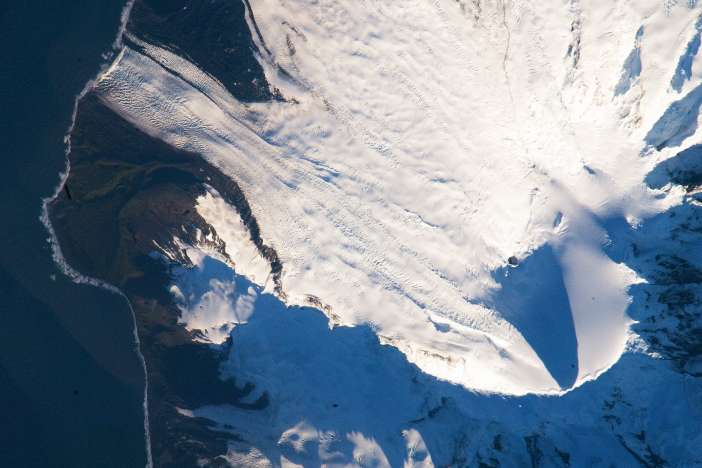 Satellite image of the southern tip of Heard Island. Cape Arkona is seen on the left side of the image, with Lied Glacier just above and Gotley Glacier just below. Big Ben Volcano and Mawson Peak are seen at the lower right side of the image. | |
| Highest point | |
| Elevation | 2,745 m (9,006 ft)[1] |
| Prominence | 2,745 m (9,006 ft) |
| Isolation | 1,922 km (1,194 mi) |
| Listing | Country high point |
| Coordinates | 53°6′00″S 73°31′00″E |
| Geography | |
 Mawson Peak Location of Heard Island | |
| Location | Heard Island, Australia |
| Parent range | Big Ben |
| Topo map | RAN Heard Island 291 |
| Geology | |
| Mountain type | Volcanic cone |
| Last eruption | 2012 to 2018 (ongoing)[2] |
With an elevation of 2,745 metres (9,006 ft), it is the third highest peak in any state or territory of Australia,[3] higher than the 2,228-metre (7,310 ft) Mount Kosciuszko, and surpassed only by the 3,490-metre (11,450 ft) Mount McClintock and the 3,355-metre (11,007 ft) Mount Menzies claimed in the Australian Antarctic Territory.[4] The peak erupted as recently as April 2013 and February 2016.[5]
Discovery and naming
Mawson Peak was named by the 1948 ANARE Heard Island Expedition after the Australian geologist and explorer Sir Douglas Mawson, the leader of BANZARE 1929–31, who visited the island in November – December 1929.[6]
On 20 February 1950, whilst aboard HMAS Lebuan, Thomas Gratton (Tim) Young OAM observed and recorded in the ship's log that Mawson Peak was an active volcano.
The 1964–65 expedition to Heard Island was led by Major Warwick Deacock, with the schooner Patanela skippered by Major Bill Tilman. They succeeded in climbing Mawson Peak for the first time, which is the highest point on this remote island.
See also
References
Citations
- "Mawson Peak, Heard Island". earthobservatory.nasa.gov. 16 March 2009.
- "Heard Island". 25 July 2018.
- "Highest mountains on external territories". Australian Government – Geoscience Australia. 15 May 2014. Retrieved 23 May 2016.
- U.S. Geological Survey Geographic Names Information System: Mawson Peak
- "Scientists witness 'amazing' eruption of volcano on sub-Antarctic island". ABC News. February 2016. Retrieved 1 February 2016.
- "Mawson Peak". Antarctic Gazetteer Name Details. Australian Antarctic Division. Retrieved 5 April 2010.
Sources
- LeMasurier, WE; Thomson, JW, eds. (1990). Volcanoes of the Antarctic Plate and Southern Oceans. American Geophysical Union. ISBN 0-87590-172-7.
- "Article". Aurora. 30 (3). March 2011.
External links
- Map of Heard Island and McDonald Islands, including all major topographical features
- Antarctic Names
- Volcano
- Data
На других языках
[de] Mawson Peak
Mawson Peak ist der höchste Berg des komplexen Vulkanmassivs Big Ben auf der Insel Heard im australischen Außengebiet Heard und McDonaldinseln. Mit 2745 m Höhe ist er der höchste Gipfel auf australischem Staatsgebiet. Heard liegt nördlich von 60° Süd, aber innerhalb der antarktischen Konvergenz, sodass Mawson Peak je nach Definition im Indischen Ozean oder im Südpolarmeer liegt.- [en] Mawson Peak
[fr] Pic Mawson
Le pic Mawson, en anglais Mawson Peak, est un volcan d'Australie situé sur l'île Heard, dans le territoire extérieur des îles Heard-et-MacDonald situé dans le sud de l'océan Indien[1]. Culminant à 2 745 mètres d'altitude, il est le point culminant du territoire australien devant le mont Kosciuszko qui s'élève à 2 228 mètres d'altitude[1].[it] Mawson Peak
Mawson Peak è una montagna situata su Heard Island, un territorio australiano nei Mari antartici. Con i suoi 2.745 metri è la seconda vetta più alta di tutti i territori australiani, compresi i territori cosiddetti esterni, preceduto dal Monte McClintock, alto 3.492 m e situato nel Territorio antartico australiano, e seguito dal Monte Kosciuszko situato sul continente australiano, alto 2.228 m.[ru] Моусон-Пик
Моусон-Пик (англ. Mawson Peak) — вулкан на острове Херд в массиве Биг-Бен.Другой контент может иметь иную лицензию. Перед использованием материалов сайта WikiSort.org внимательно изучите правила лицензирования конкретных элементов наполнения сайта.
WikiSort.org - проект по пересортировке и дополнению контента Википедии