geo.wikisort.org - Mountains
Big Ben (previously known as Big Ben Peak, Old Ben Mountain, Emperor William Peak and Kaiser Wilhelm-Berg)[1] is a volcanic massif that dominates the geography of Heard Island in the southern Indian Ocean. It is a stratovolcano with a diameter of about 25 km (16 mi). Its highest point is Mawson Peak, which is 2,745 m (9,006 ft) above sea level. Much of it is covered by ice, including 14 major glaciers which descend from Big Ben to the sea. Big Ben is the highest mountain in Australian states and territories, except for those claimed in the Australian Antarctic Territory.[3] A smaller volcanic headland, the Laurens Peninsula, extends about 10 km (6 mi) to the northwest, created by a separate volcano, Mount Dixon; its highest point is Anzac Peak, at 715 m (2,346 ft).
| Big Ben | |
|---|---|
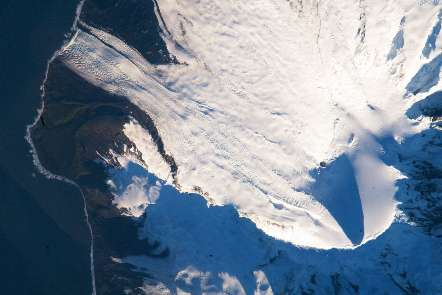 Satellite image of the southern tip of Heard Island. Cape Arkona is seen on the left side of the image, with Lied Glacier just above and Gotley Glacier just below. Big Ben and Mawson Peak are seen at the lower right side of the image. | |
| Highest point | |
| Elevation | 2,745 m (9,006 ft)[1] |
| Prominence | 2,745 m (9,006 ft)[1] |
| Listing | Country high point Ultra |
| Coordinates | 53°06′00″S 73°31′00″E[1] |
| Geography | |
 Location of Big Ben | |
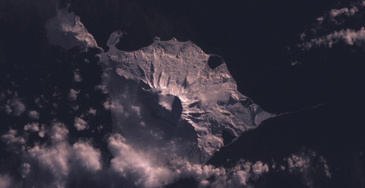
| Location | Heard Island, Australia |
| Topo map | RAN Heard Island 291 |
| Geology | |
| Age of rock | Quaternary |
| Mountain type | Stratovolcano |
| Last eruption | 2012 – ongoing (as of 2021)[2] |
Volcanic activity
Volcanic activity at the cone has been known since 1881. An eruption occurred in 1993.[4] Satellite images detected eruptions during 2000. On 2 February 2016, observations from Atlas Cove, 15 km (9 mi) northwest of Mawson Peak, showed plumes up to 1 km (3,300 ft) high over the volcano. Satellite images showed hotspots at various times from 2003 to 2008, and during September 2012.[5] A further eruption was reported on 2 February 2016, and was recorded by scientists who happened to be in the area on an expedition. Big Ben does not endanger humans because Heard Island is uninhabited.[6]
Big Ben is in a remote location, and without regular observation it is possible that eruptions have occurred at other times.
See also
References
- "Big Ben". Geographic Names Information System. United States Geological Survey, United States Department of the Interior. Retrieved 2019-08-10.
- "Heard". Global Volcanism Program. Smithsonian Institution. Retrieved 2019-08-10.
- Division, c=AU;o=Commonwealth of Australia;ou=Department of the Environment;ou=Australian Antarctic. "Frequently asked questions". heardisland.antarctica.gov.au. Retrieved 2016-05-23.
- Big Ben
- Heard Island Volcano - John Seach
- "Scientists film Big Ben sub-Antarctic volcano eruption". BBC News. Retrieved 2016-02-02.
- LeMasurier, W. E.; Thomson, J. W., eds. (1990). Volcanoes of the Antarctic Plate and Southern Oceans. American Geophysical Union. p. 512 pp. ISBN 0-87590-172-7.
External links
- Click here to see a map of Heard Island and McDonald Islands, including all major topographical features
- Location and history of Heard Island
- Australian Government (Department of Sustainability, Environment, Water, Population and Communities) Heard Island and MacDonald Islands (HIMI) website
На других языках
[de] Big Ben (Vulkan)
Big Ben ist ein Schichtvulkan auf der unbewohnten subantarktischen Insel Heard, die zum australischen Außengebiet Heard und McDonaldinseln gehört. Der höchste Punkt (Mawson Peak, benannt nach dem australischen Polarforscher Douglas Mawson) liegt 2745 Meter über dem Meeresspiegel. Mit einer Fläche von etwa 360 km² bedeckt der Berg fast das gesamte Zentralgebiet der Insel.- [en] Big Ben (Heard Island)
[fr] Big Ben (île Heard)
Le Big Ben, aussi appelé mont Kaiser Wilhelm[3], est un massif volcanique d'Australie situé sur l'île Heard, dans le territoire extérieur des îles Heard-et-MacDonald situé dans le sud de l'océan Indien. Constituant la majorité de l'île Heard et en grande partie recouvert de glaciers, il est couronné par une caldeira en fer à cheval ouverte sur l'océan Indien et contenant le pic Mawson qui, avec 2 745 mètres d'altitude, est le point culminant du massif, de l'île Heard et du pays en tenant compte de la totalité du territoire australien.[ru] Биг-Бен (вулкан)
Биг-Бен — активный базальтовый стратовулкан, представляющий собой вершину подводного хребта Кергелен, образующий остров Херд.Другой контент может иметь иную лицензию. Перед использованием материалов сайта WikiSort.org внимательно изучите правила лицензирования конкретных элементов наполнения сайта.
WikiSort.org - проект по пересортировке и дополнению контента Википедии