geo.wikisort.org - Mountains
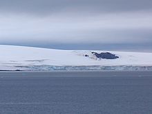
Malamir Knoll (Malamirova Mogila \ma-la-'mi-ro-va mo-'gi-la\) rises to 200 m in the southeast extremity of the Dryanovo Heights, Greenwich Island in the South Shetland Islands, Antarctica. It has precipitous and ice-free southwest slopes and was named after the Bulgarian ruler Khan Malamir, 831-836 AD.


The knoll is located at 62°30′10″S 59°48′13″W, which is 2.37 km east of Tile Ridge, and 2.9 km northeast of Triangle Point, 2.65 km north-northwest of Spit Point and 3.78 km west by south of Labbé Point (Bulgarian topographic survey Tangra 2004/05 and mapping in 2005 and 2009).
Maps
- L.L. Ivanov et al. Antarctica: Livingston Island and Greenwich Island, South Shetland Islands. Scale 1:100000 topographic map. Sofia: Antarctic Place-names Commission of Bulgaria, 2005.
- L.L. Ivanov. Antarctica: Livingston Island and Greenwich, Robert, Snow and Smith Islands. Scale 1:120000 topographic map. Troyan: Manfred Wörner Foundation, 2009.
References
- Malamir Knoll. SCAR Composite Antarctic Gazetteer
- Bulgarian Antarctic Gazetteer. Antarctic Place-names Commission. (details in Bulgarian, basic data in English)
External links
- Malamir Knoll. Copernix satellite image
This article includes information from the Antarctic Place-names Commission of Bulgaria which is used with permission.
На других языках
[de] Malamir Knoll
Der Malamir Knoll (bulgarisch Маламирова могила .mw-parser-output .Latn{font-family:"Akzidenz Grotesk","Arial","Avant Garde Gothic","Calibri","Futura","Geneva","Gill Sans","Helvetica","Lucida Grande","Lucida Sans Unicode","Lucida Grande","Stone Sans","Tahoma","Trebuchet","Univers","Verdana"}Malamirowa mogila) ist ein 200 m hoher Hügel auf Greenwich Island im Archipel der Südlichen Shetlandinseln. Am südöstlichen Ausläufer der Dryanovo Heights ragt er 2,3 km östlich des Tile Ridge und 2,8 km nordöstlich des Triangle Point auf. Besonders markant ist er durch seine eisfreien Südhänge.- [en] Malamir Knoll
Текст в блоке "Читать" взят с сайта "Википедия" и доступен по лицензии Creative Commons Attribution-ShareAlike; в отдельных случаях могут действовать дополнительные условия.
Другой контент может иметь иную лицензию. Перед использованием материалов сайта WikiSort.org внимательно изучите правила лицензирования конкретных элементов наполнения сайта.
Другой контент может иметь иную лицензию. Перед использованием материалов сайта WikiSort.org внимательно изучите правила лицензирования конкретных элементов наполнения сайта.
2019-2025
WikiSort.org - проект по пересортировке и дополнению контента Википедии
WikiSort.org - проект по пересортировке и дополнению контента Википедии