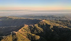
 Loma Prieta (the peak just right of center) and other nearby peaks are festooned with television broadcast towers and other communication towers, serving the Santa Clara Valley. Fog-shrouded Monterey Bay and the Monterey peninsula are visible in the background in this late-afternoon approach to San José International Airport.
geo.wikisort.org - Mountains
Loma Prieta (from Spanish loma -hill, prieta -dark) is 3,790 feet (1,160 m) high and is the highest peak in the Santa Cruz Mountains in Northern California.[3]
| Loma Prieta Peak | |
|---|---|
 Loma Prieta from the West | |
| Highest point | |
| Elevation | 3,790 ft (1,155 m) NAVD 88[1] |
| Prominence | 3,426 ft (1,044 m) NGVD 29[2] |
| Coordinates | 37°06′40″N 121°50′39″W[1] |
| Naming | |
| English translation | Dark Hill |
| Language of name | Spanish |
| Geography | |
 Loma Prieta Peak Santa Clara County, California, U.S.  Loma Prieta Peak Loma Prieta Peak (the United States) | |
| Parent range | Santa Cruz Mountains |
| Topo map | USGS Loma Prieta |
| Climbing | |
| Easiest route | RoadAlexander Dallas Bache |
Although the 1989 Loma Prieta earthquake was named for this mountain, the actual epicenter was five miles southwest of the peak, across the San Andreas fault, in the The Forest of Nisene Marks State Park.
In the 19th century, the peak was called Mount Bache, a name given in honor of Alexander Dallas Bache; the name is no longer in use.[4]
From 1955 to 2005, the mountain was the longtime site for the transmitter tower of San Jose television station KNTV. In September 2005, it moved its transmitter 83 kilometres (52 mi) northwest to San Bruno Mountain after it became the Bay Area's NBC affiliate.
Geology
Loma Prieta is the tallest peak in the Santa Cruz Mountains and it is common to see snow on the mountain during the winter.
Loma Prieta and other nearby mountain peaks are pushed upward by local collision forces associated with a left bend in the San Andreas fault. Starting near Uvas Canyon, the fault stops trending northwest but instead bends west-northwest for about eight miles before continuing its northwest direction. This left bend is renowned among geologists as a archetypal restraining bend which acts to oppose strike-slip motion along the fault.[5] From the perspective of Loma Prieta and other mountains atop the Sierra Azul block, the Pacific Plate is trying to shear them off the North American Plate but can't break them off. Rather, the resulting transpression force pushes up the local terrain and helps explain why these are the highest peaks in the Santa Cruz Mountains.[6]
Astronomy
From 1976 through 1990 amateur astronomer Donald Machholz set up his telescope an average of 120 times a year on the south slope of this mountain to search for comets. From this site he discovered three new comets that bear his name, including Periodic Comet Machholz 1 96P/Machholz on May 12, 1986.
The first official West Coast Messier marathon was conducted from this site in March 1979.

See also
References
- "Loma Prieta Reset". NGS Data Sheet. National Geodetic Survey, National Oceanic and Atmospheric Administration, United States Department of Commerce. Retrieved 2009-08-07.
- "Loma Prieta Peak , California". Peakbagger.com. Retrieved 2009-08-07.
- "Loma Prieta". Geographic Names Information System. United States Geological Survey, United States Department of the Interior.
- Brewer, William Henry. Up and Down California in 1860-1864; The Journal of William H. Brewer: Book 2, Chapter 3 NEW ALMADEN. Retrieved 20 June 2019.
- Hilley, G.E.; Dumitru, T.; Gudmundsdottir, M.H.; Burgmann, R. (December 2008). "Exhumation history of the Sierra Azul Block of the Santa Cruz Mountains Revealed Using Low Temperature Thermochronology". American Geophysical Union, Fall Meeting 2008. Bibcode:2008AGUFM.T43E..02H. Retrieved 2022-10-01.
- Sloan, Doris (2006). Geology of the San Francisco Bay Region. Berkeley, California: University of California Press. p. 43. ISBN 978-0-520-24126-8.
External links
| Peaks |  | |
|---|---|---|
| Rivers and creeks |
| |
| Parks |
| |
| Hiking trails |
| |
| Open Space Preserves |
| |
| Other |
| |
Authority control | |
|---|---|
| General |
|
| National libraries | |
| Other |
|
На других языках
[de] Loma Prieta
Loma Prieta ist ein Berg im kalifornischen Santa Clara County. Mit 1155 m[1] Höhe ist er der höchste Berg der Santa Cruz Mountains an der Pazifikküste. Sein Name kommt aus dem Spanischen und bedeutet etwa „Dunkler Hügel“. Der Gipfel ist über eine unbefestigte Straße erreichbar und Standort zahlreicher Sendeanlagen. Vom Loma Prieta aus entdeckte der Amateurastronom Don Edward Machholz mehrere Kometen, darunter 96P/Machholz.[2]- [en] Loma Prieta
[fr] Pic Loma Prieta
Le pic Loma Prieta est une montagne du centre de la Californie aux États-Unis qui s'élève à 1 154 m d'altitude. Il est le point culminant des monts Santa Cruz.Текст в блоке "Читать" взят с сайта "Википедия" и доступен по лицензии Creative Commons Attribution-ShareAlike; в отдельных случаях могут действовать дополнительные условия.
Другой контент может иметь иную лицензию. Перед использованием материалов сайта WikiSort.org внимательно изучите правила лицензирования конкретных элементов наполнения сайта.
Другой контент может иметь иную лицензию. Перед использованием материалов сайта WikiSort.org внимательно изучите правила лицензирования конкретных элементов наполнения сайта.
2019-2026
WikiSort.org - проект по пересортировке и дополнению контента Википедии
WikiSort.org - проект по пересортировке и дополнению контента Википедии