geo.wikisort.org - Mountains
The Lincolnshire Wolds are a range of low hills in the county of Lincolnshire, England which run roughly parallel with the North Sea coast, from the Humber Estuary in the north-west to the edge of the Lincolnshire Fens in the south-east. They are a designated Area of Outstanding Natural Beauty (AONB), and the highest area of land in eastern England between Yorkshire and Kent.[1][2]
| Lincolnshire Wolds | |
|---|---|
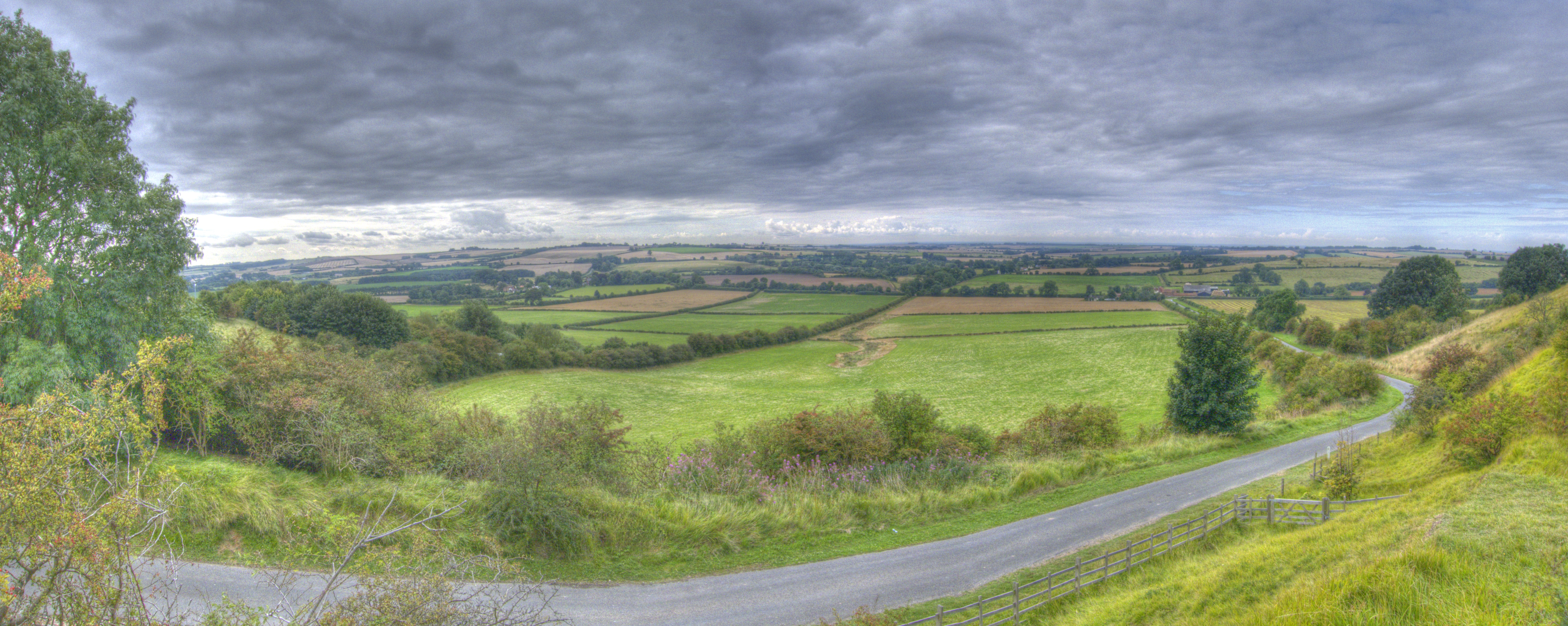
 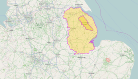 The Lincolnshire Wolds near Stainton le Vale (top), location within Lincolnshire (bottom) | |
| Location | Lincolnshire, England |
| Coordinates | 53°21′0″N 0°6′0″W |
| Area | 560 km2 (220 sq mi) |
| Established | 1973 |
| Governing body | Lincolnshire Wolds Countryside Service |
Geology
The Wolds are formed largely from a series of pure marine limestones formed during the Cretaceous period, known collectively as the Chalk Group. The chalk overlies a series of other sedimentary strata of late Jurassic/early Cretaceous age. The strata dip gently to the east and form a scarp which runs southeast from Barton upon Humber via Caistor before it loses its identity north of Spilsby. To the north of the Humber Gap, the same formations continue as the Yorkshire Wolds.[2] The rock succession in stratigraphic order i.e. youngest/uppermost first, is this:
- White Chalk Subgroup
- Burnham Chalk formation
- Welton Chalk Formation
- Grey Chalk Subgroup
- Ferriby Chalk Formation
- Hunstanton Chalk Formation
The thin Hunstanton Chalk and the Ferriby Chalk formations form much of the west facing Wolds scarp but it is the overlying Welton Chalk Formation which forms the greater part of the easterly dip-slopes with the Ferriby Chalk extensively exposed within the dry dip-slope valleys. The Burnham Chalk Formation forms an indistinct secondary scarp to the east of the main scarp between Barton and Louth. In the north between South Ferriby and Grasby, the lower part of the scarp is formed from the Kimmeridge Clay Formation. A series of other rock layers intervene from the Caistor area southwards, uppermost of which are the green-brown Carstones:
Lower/early Cretaceous
- Carstone Formation (sandstone)
- Roach Formation (interbedded mudstone and limestone) (present from Stenigot southwards)
- Tealby Formation (mudstone - but including the 'Tealby Limestone Member')
- Claxby Ironstone Formation
Upper/late Jurassic
- Spilsby Sandstone Formation
- Kimmeridge Clay Formation
The numerous dry valleys cut into the dip-slope are typically floored by head, locally derived clay, silt, sand and gravel. The western valleys were created during recent glacial periods through the action of water over frozen ground whilst many in the east represent subglacial drainage.[3] During the last ice age (Devensian), ice encroached upon the Wolds from the northeast and entered the Humber gap from the east but did not cover the Wolds, hence there is no Devensian age glacial till on these hills. However an earlier ice age left extensive spreads of till across the central and southern areas.[4] Sections of the main scarp, notably at Saxby All Saints and between Nettleton and Walesby have been subject to landslip.[5]
Geography
The Wolds comprise a series of low hills incised by characteristic dry open valleys.
The Lincolnshire Wolds can be divided into four distinct areas:[2]
- the main area of chalk hills in the north,
- the north west scarp,
- an area of ridges and valleys in the south west,
- the claylands in the south east.
The Red Hill nature reserve near the village of Goulceby is notable for the unusual red colour of its soil and underlying chalk.
Wolds Top is the highest point in the whole of Lincolnshire and is marked by a trig point just north of the village of Normanby le Wold, at approximately 551 feet (168 metres) above sea level (TF121964).[1]
Other hills include:
- Castcliffe Hill - TF301735 - 456 feet (139 m)
- Gaumer Hill - TF289778 - 423 feet (129 m)
- Meagram Top - TF392789 - 190 feet (58 m)
- Warden Hill - TF347737 - 371 feet (113 m)
- Tetford Hill - TF326761 - 466 feet (142 m)
- Hoe Hill - TF308731 - 417 feet (127 m)
The Wolds provide views across the flat Fens and salt marshes of Lindsey and Holland: it is possible, from various points on the Wolds, to see all of the larger structures in the north and east of the county: the Belmont mast, Boston Stump, Grimsby Dock Tower, the Humber Bridge, Lincoln Cathedral, St James' Church in Louth (known locally as the 'Cathedral of the Wolds', though it holds only parish church status), the radar station near Normanby, Tattershall Castle and the wind turbines on the coast near Mablethorpe.
Waterways
| Name | Length | Source | Source Elevation (m) | Mouth | Mouth Elevation (m) | Notes |
|---|---|---|---|---|---|---|
| River Bain | Ludford | 130 | River Witham, Dogdyke | 2 | ||
| Great Eau | North Sea, Saltfleet Haven | |||||
| River Lud | North Sea, North Coates | Also known as the Louth Navigation due to its canalisation. | ||||
| River Lymn | Belchford | 91 | North Sea, Gibraltar Point | 0 | ||
| River Rase | Tealby | 118 | River Ancholme, Bishopbridge | 6 | ||
| River Waring | Belchford | 100 | River Bain, Horncastle | 28 |
Area of Outstanding Natural Beauty
The Lincolnshire Wolds were designated an Area of Outstanding Natural Beauty (AONB) in 1973, and are managed as such by the Lincolnshire Wolds Countryside Service.[6][7]
The Wolds AONB covers 560 square kilometres, while the Countryside Service recognises a wider Lincolnshire Wolds Character/Natural Area which incorporates the AONB and the neighbouring areas of the (geographical) Wolds to the north and south.[2]
The Wolds AONB cuts across the council boundaries of Lincolnshire County Council, East Lindsey District Council, West Lindsey District Council and North East Lincolnshire Council.[1][2] The boundaries of the AONB are marked by tourist signs incorporating stylized hills and trees, placed on roads leading into the area.
People and places
The Wolds are sparsely populated and have a rural character. They are 'ringed' by several small market towns that lie around their edge:[1]
- Alford
- Horncastle, billed on tourist signs as the "gateway to the Wolds", lies just outside the south end of the AONB
- Louth
- Market Rasen
- Caistor
- Spilsby
Many of the place-names in the Wolds indicate a strong Viking influence in the area's history. There is also an abundance of mediaeval 'lost villages' – settlements abandoned due to changes in land use, soil exhaustion and disease.
Several notable roads and paths run over the Wolds. Caistor High Street, the path of a Roman road and now the route of the B1225, runs from Caistor to Baumber near Horncastle. The ancient Bluestone Heath Road follows the course of an ancient drove road from west to east across the Wolds, and several "A" roads also run through the AONB.[1]
The Wolds are now promoted as a tourist destination: the area's connection with Tennyson (who was born in Somersby) is being exploited,[8][9] and farmers are being encouraged to diversify into the tourism industry. The roads of the Wolds are particularly popular with motorcyclists, and the area is home to Cadwell Park, one of the UK's top race circuits.[10][11]
The area is also popular with walkers: the Viking Way long-distance footpath runs from Barton-upon-Humber in North Lincolnshire across the Lincolnshire Wolds and into Rutland,[12][13] and there is a youth hostel in the middle of the Wolds at Woody's Top near the village of Tetford.[14][15]
References
- Ordnance Survey maps:
Lincolnshire Wolds North (Map) (A1 ed.). 1:25000. Explorer. Ordnance survey of Great Britain. 3 April 2006. § 282. ISBN 978-0319238233.
Lincolnshire Wolds South (Map) (A1 ed.). 1:25000. Explorer. Ordnance survey of Great Britain. 3 April 2006. § 273. ISBN 978-0319238219. - "NCA Profile: 43 Lincolnshire Wolds (NE440)". Publications and products. Natural England. Retrieved 13 October 2013.
- "1:50000 Series England and Wales sheet 90, Grimsby (including sheet 91 Saltfleet), Solid and Drift Geology". Maps Portal. British Geological Survey. Retrieved 19 July 2020.
- Kent, Peter (1980). British Regional Geology: Eastern England from the Tees to The Wash (second ed.). London: Institute of Geological Sciences, HMSO. pp. 118–125.
- "Geoindex Onshore". British Geological Survey. Retrieved 18 July 2020.
- "Lincolnshire wolds". Lincolnshire wolds countryside service. Retrieved 13 October 2013.
- "AONB facts and figures". Natural England. Archived from the original on 14 October 2013. Retrieved 13 October 2013.
- "The birthplace of Tennyson". St Margaret's Somersby PCC. Retrieved 13 October 2013.
- "Birth Place of Lord Alfred Tennyson, Somersby, Lincolnshire". Explore Lincolnshire. Archived from the original on 16 October 2013. Retrieved 13 October 2013.
- "Cadwell park race circuit". Retrieved 13 October 2013.
- Miodonski, James (23 August 2014). "BSB Round 8 Cadwell Park". MotoGoLoco.com. Retrieved 30 January 2021.
- "The Viking way". Lincolnshire county council. Retrieved 13 October 2013.
- "The Viking way". Long Distance Walkers Association. Retrieved 13 October 2013.
- "Woody's Top". Youth Hostel Association. Retrieved 13 October 2013.
- "Woody's Top youth hostel". Visit Lincolnshire. Archived from the original on 14 October 2013. Retrieved 13 October 2013.
- "Landscape character". Lincolnshire Wolds Area of Outstanding Natural Beauty. Lincolnshire Wolds Countryside Service. Retrieved 12 October 2013.
- "43 Lincolnshire Wolds". National Character Areas. Natural England. Retrieved 12 October 2013.
- "The Lincolnshire Wolds". Areas of outstanding natural beauty. Natural England. Retrieved 12 October 2013.
- "The Lincolnshire Wolds AONB". Lincolnshire landscapes. Greater Lincolnshire nature partnership. Retrieved 12 October 2013.
- Rawding, C. (2001). The Lincolnshire Wolds in the nineteenth century. Lincoln: History of Lincolnshire Committee.
- The Lincolnshire Wolds Landscape. Landscape Character Assessment. Natural England Publications, Communisis Print Management, Balliol Business Park West, Benton Lane, Newcastle upon Tyne, NE12 8EW: The Countryside Commission. 1993.
{{cite book}}: CS1 maint: location (link)Precursor to the Natural England designation - Thorold., Henry; Yates, Jack (1968). Lincolnshire. The Shell Guide. London: Faber & Faber.
- "Spilsby Sandstone". Lexicon of Named Rock Units. British geological survey. Retrieved 12 October 2013.
External links
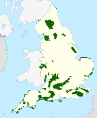
Areas of Outstanding Natural Beauty in England | ||
|---|---|---|
| East of England |
|  |
| East Midlands | ||
| North East |
| |
| North West |
| |
| South East |
| |
| South West |
| |
| West Midlands |
| |
| Yorkshire and the Humber |
| |
| ||
На других языках
[de] Lincolnshire Wolds
Die Lincolnshire Wolds[1] sind ein Hügelzug in der englischen Grafschaft Lincolnshire. Sie sind das höchstgelegene Gebiet im östlichen England zwischen Yorkshire und Kent. Der Hügelzug verläuft parallel zur englischen Nordseeküste vom Ästuar des Humber im Nordwesten bis zur Kleinstadt Spilsby im Südosten.- [en] Lincolnshire Wolds
Другой контент может иметь иную лицензию. Перед использованием материалов сайта WikiSort.org внимательно изучите правила лицензирования конкретных элементов наполнения сайта.
WikiSort.org - проект по пересортировке и дополнению контента Википедии