geo.wikisort.org - Mountains
Kerið (Icelandic pronunciation: [ˈcʰɛːrɪθ]; also Kerith or Kerid) is a volcanic crater lake located in the Grímsnes area in south Iceland, along the Golden Circle. It is one of several crater lakes in the area, known as Iceland's Western Volcanic Zone, which includes the Reykjanes peninsula and the Langjökull Glacier, created as the land moved over a localized hotspot, but it is the one that has the most visually recognizable caldera still intact. The caldera, like the other volcanic rock in the area, is composed of a red (rather than black) volcanic rock. The caldera itself is approximately 55 m (180 ft) deep, 170 m (560 ft) wide, and 270 m (890 ft) across. Kerið's caldera is one of the three most recognizable volcanic craters because at approximately 6,500 years old, it is only half the age of most of the surrounding volcanic features. The other two are Seyðishólar and Kerhóll.
This article needs additional citations for verification. (February 2008) |

While most of the crater is steep-walled with little vegetation, one wall is sloped more gently and blanketed with a deep moss, and can be descended fairly easily. The lake itself is fairly shallow (7–14 metres, depending on rainfall and other factors), but due to minerals from the soil, is an opaque and strikingly vivid aquamarine.
Land owners charge an entrance fee to see the crater of 400 ISK (as of October 2022[update]).
Formation
Although volcanologists originally believed Kerið was formed by a huge volcanic explosion, as is the accepted norm with volcanic craters, more thorough studies of the Grímsnes region failed to find any evidence of such an explosion in Kerið. It is now believed that Kerið was a cone volcano which erupted and emptied its magma reserve. Once the magma was depleted, the weight of the cone collapsed into the empty magma chamber. The current pool of water at the bottom of the crater is at the same level as the water table and is not caused by rainfall.[1]
Gallery
 Kerið in April 1980
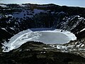 Kerið frozen over in early April
 Kerið in September
 Kerið in April
 Kerið in August
 Kerið
Kerið Kerið
Kerið Kerið in early March
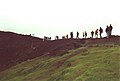 Tourists on the edge of Kerið in July
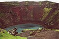 Kerið in July
 Kerið in mid April


References
- Information board next to Kerith Crater
This Iceland location article is a stub. You can help Wikipedia by expanding it. |
На других языках
[de] Kerið
Der Kerið ist ein Kratersee in Island. Er ist der östlichste von fünf Kratern der zum postglazialen Grímsnes-Vulkanfeld gehörenden Kraterreihe Tjarnarhólar, die ihrerseits zum Eruptionsgürtel im Reykjanes–Langjökull–Gebiet zählen. Kerið liegt in der Region Suðurland an der Straße von Selfoss ins Haukadalur.- [en] Kerið
[it] Kerið
Kerið è un lago craterico islandese. Si trova nell'area dei Grímsnes e fa parte del Cerchio d'Oro.[ru] Керид
Керид (исл. Kerið) — вулканическое озеро на юге Исландии, близ города Сельфосс. Расположено на популярном туристическом пути, известном как Золотое кольцо.Другой контент может иметь иную лицензию. Перед использованием материалов сайта WikiSort.org внимательно изучите правила лицензирования конкретных элементов наполнения сайта.
WikiSort.org - проект по пересортировке и дополнению контента Википедии