geo.wikisort.org - Mountains
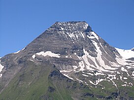
The Hohe Dock lies in the Austrian federal state of Salzburg and, at 3,348 metres, is one of the highest peaks in the Glockner Group. The mountain, with its striking trapezoidal shape, dominates the orographically left-hand side of the valley of the Fuscher Ache and the panorama above the northern ramp of the Großglockner High Alpine Road.
| Hohe Dock | |
|---|---|
 Hohe Dock from the Großglockner High Alpine Road | |
| Highest point | |
| Elevation | 3348 m AA |
| Isolation | 0.6 km (0.37 mi) |
| Coordinates | 47°07′51″N 12°44′27″E |
| Geography | |
| Location | Salzburg, Austria |
| Parent range | Glockner Group / High Tauern |
| Climbing | |
| First ascent | ca. 1842 - 1845 G. Mayer (Badhans) during a hunt[1] |
Its secondary peak, the southeastern summit, reaches a height of 3,268 m above sea level (AA).
Climbing route
The start point is the head of the valley at Fusch an der Großglocknerstraße (Ferleiten). The summit is ascended via the Schwarzenberg Hut (2,267 m) along a signed, high alpine path.
References
External links
- Climbing the Hohe Dock - (Czech / English)
Gallery
- The Hohe Dock from the northeast
На других языках
[de] Hohe Dock
Die Hohe Dock liegt im Bundesland Salzburg in Österreich und ist mit einer Höhe von 3348 m ü. A. einer der höheren Gipfel der Glocknergruppe. Der Berg dominiert mit seiner markanten Trapezform die orografisch linke Seite des Tals der Fuscher Ache und auch das Panorama auf der Nordrampe der Großglockner-Hochalpenstraße.- [en] Hohe Dock
Текст в блоке "Читать" взят с сайта "Википедия" и доступен по лицензии Creative Commons Attribution-ShareAlike; в отдельных случаях могут действовать дополнительные условия.
Другой контент может иметь иную лицензию. Перед использованием материалов сайта WikiSort.org внимательно изучите правила лицензирования конкретных элементов наполнения сайта.
Другой контент может иметь иную лицензию. Перед использованием материалов сайта WikiSort.org внимательно изучите правила лицензирования конкретных элементов наполнения сайта.
2019-2025
WikiSort.org - проект по пересортировке и дополнению контента Википедии
WikiSort.org - проект по пересортировке и дополнению контента Википедии

