geo.wikisort.org - Mountains
The Heidkopf is a 272.6 m high hill in the Wiehen in Minden-Lübbecke district within the borough of Lübbecke. It lies one kilometre north of the Heidbrink and 500 metres northeast of the Reineberg.
This article does not cite any sources. (May 2019) |
| Heidkopf | |
|---|---|
 Heidkopf south of Lübbecke, North Rhine-Westphalia | |
| Highest point | |
| Elevation | 273 m above sea level (896 ft) |
| Coordinates | 52°17′51″N 8°38′05″E |
| Geography | |
| Location | south of Lübbecke, North Rhine-Westphalia |
| Parent range | Wiehen Hills |
| Climbing | |
| Normal route | Fußweg |
The Heidkopf is not very spectacular and is not well known even amongst the townsfolk of Lübbecke. Its summit is partly covered by old beech trees. A footpath runs from the northeast up to the summit. A metalled forest track runs around the hill. Between the Reineberg and the Heidkopf is a ravine that is still very much in a natural state, in which a stream rises, taking its source water from the Wittekind Spring.
 |
 |
Gallery
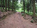 Only this overgrown path runs from the north to the summit
 View of the summit. The trig point below right is about 10 metres from the top
 The trig point on the Heidkopf


На других языках
[de] Heidkopf (Wiehengebirge)
Der Heidkopf ist ein 273,2 m ü. NHN hoher Berg im Wiehengebirge im Kreis Minden-Lübbecke im Stadtgebiet von Lübbecke.- [en] Heidkopf (Wiehen Hills)
Текст в блоке "Читать" взят с сайта "Википедия" и доступен по лицензии Creative Commons Attribution-ShareAlike; в отдельных случаях могут действовать дополнительные условия.
Другой контент может иметь иную лицензию. Перед использованием материалов сайта WikiSort.org внимательно изучите правила лицензирования конкретных элементов наполнения сайта.
Другой контент может иметь иную лицензию. Перед использованием материалов сайта WikiSort.org внимательно изучите правила лицензирования конкретных элементов наполнения сайта.
2019-2025
WikiSort.org - проект по пересортировке и дополнению контента Википедии
WikiSort.org - проект по пересортировке и дополнению контента Википедии