geo.wikisort.org - Mountains
Haweswater is a reservoir in the valley of Mardale, Cumbria in the Lake District, England. Work to raise the height of the original natural lake was started in 1929. It was controversially dammed after the UK Parliament passed a Private Act giving Manchester Corporation permission to build the reservoir to supply drinking water to the city. The decision caused a public outcry because the farming villages of Measand and Mardale Green would be flooded and the valley altered forever.
| Haweswater Reservoir | |
|---|---|
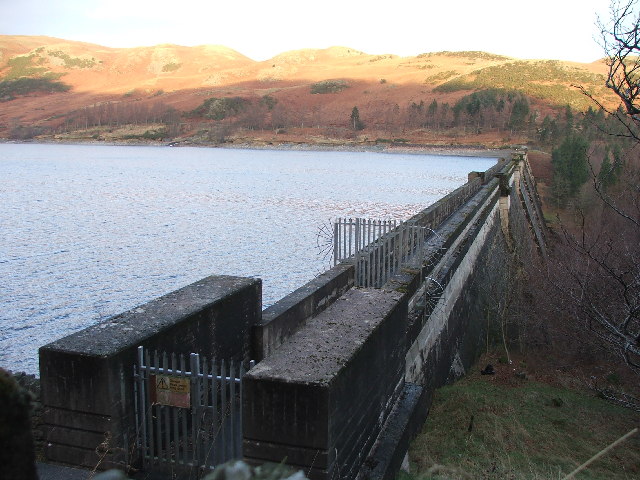
 Reservoir seen from Harter Fell, Mardale | |
| Location | Lake District, Cumbria |
| Coordinates | 54°31′08″N 2°48′17″W |
| Type | reservoir, natural lake |
| Primary inflows | Mardale Beck, Riggindale Beck |
| Primary outflows | Haweswater Beck |
| Basin countries | England |
| Max. length | 6.7 km (4.2 mi)[1] |
| Max. width | 900 m (3,000 ft)[1] |
| Surface area | 3.9 km2 (1.5 sq mi)[1] |
| Average depth | 23.4 m (77 ft)[1] |
| Max. depth | 57 m (187 ft)[1] |
| Water volume | 84 billion litres (18×109 imp gal) |
| Residence time | 500 days[1] |
| Surface elevation | 246 m (807 ft) |
| Islands | 1 |
| References | [1] |


The reservoir is now owned by United Utilities. It supplies about 25% of the North West's water supply.
Etymology
Haweswater is derived from Old Norse or Old English. 'Hafr's lake' refers to the personal Norse name 'Hafr' or in Old English 'Hæfer'; 'water' or 'wæter' is the dominant term for 'lake' in old English.[2]
Geology
Haweswater is the location of a caldera volcano succession.[3]
History
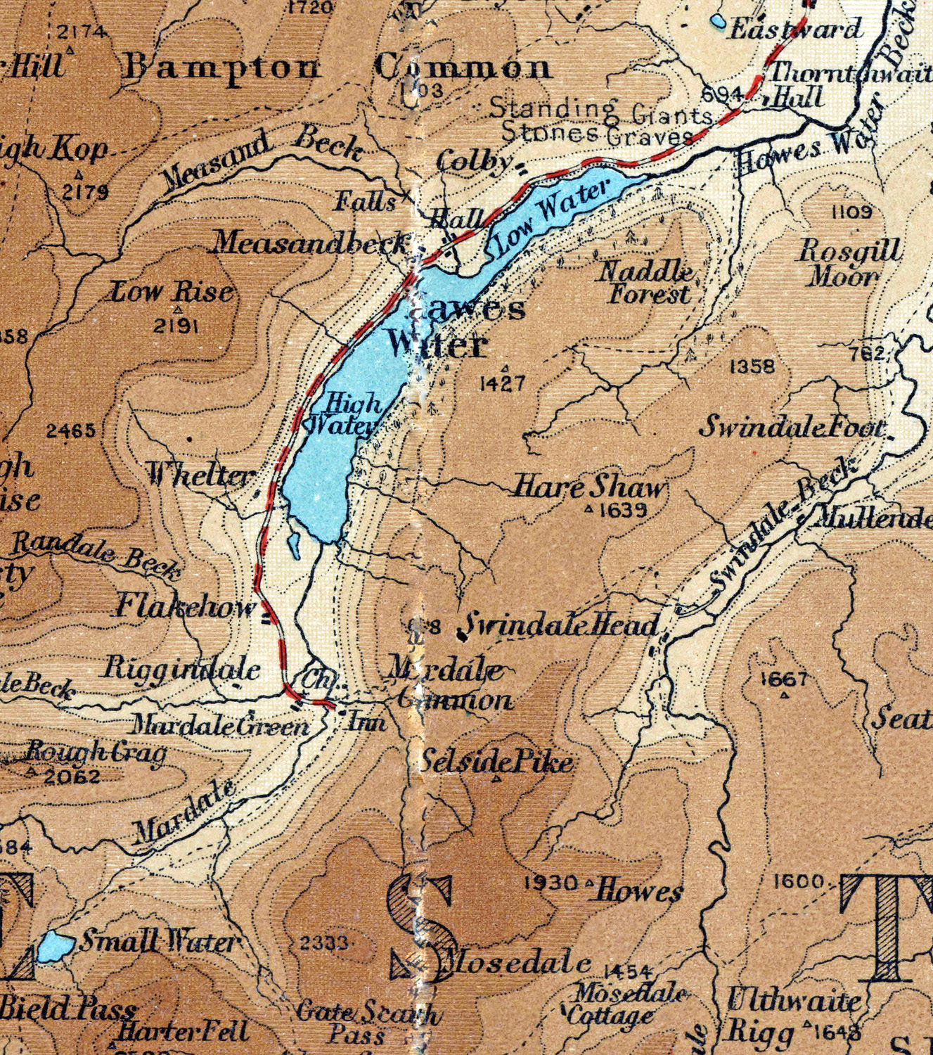
Haweswater was originally a natural lake about 4 km (2.5 mi) long. A tongue of land at Measand divided the lake almost in two. The upper and lower reaches of the lake were known as High Water and Low Water.
In 1929 work started to build the dam wall across the valley floor. At the time of construction, its design was considered to be at the forefront of civil engineering technology because it was the world's first hollow buttress dam. The wall would be created from 44 separate buttressed units joined by flexible joints. When the dam was completed by 1935, it measured 470 m (1,540 ft) long and 27.5 m (90 ft) high. It has a 1.4 m (4 ft 7 in) wide parapet that runs atop the length of the dam. Building supplies were brought to the site from the adjoining valleys of Heltondale and Swindale. When the valley was flooded, the dam raised the water level by 29 m (95 ft). This created a reservoir 6 km (3.7 mi) long and up to 600 m (2,000 ft) across at its widest point. It holds up to 84 billion litres (18×109 imp gal) of water.

Before the valley was flooded in 1935, all the farms and dwellings of the villages of Mardale Green and Measand were demolished, as well as the centuries-old Dun Bull Inn at Mardale Green. The village church was dismantled and the stone used in constructing the dam; all the bodies in the churchyard were exhumed and re-buried at Shap.
Today, when the water in the reservoir is low, the remains of the submerged village of Mardale Green can still be seen, including stone walls and the village bridge.[4]
Manchester Corporation built a new road along the eastern side of the lake to replace the flooded highway lower in the valley, and the Haweswater Hotel was constructed midway down the length of the reservoir as a replacement for the Dun Bull. The road continues to the western end of Haweswater, to a car park, a popular starting point for a path to the surrounding fells of Harter Fell, Branstree and High Street.
Wildlife

Fish
There is a population of schelly fish in the lake, believed to have lived there since the last Ice Age.
RSPB Haweswater
The Royal Society for the Protection of Birds (RSPB) first became involved in Haweswater because of the presence of golden eagles. The organisation currently manages two farms in the area.
Until 2015 Haweswater was the only place in England where a golden eagle was resident. A pair of eagles first nested in the valley of Riggindale in 1969, and the male and female of the pairing changed several times over the years, during which sixteen chicks were produced. The female bird disappeared in April 2004, leaving the male alone.[5] There was an RSPB observation post in the valley for people wishing to see the eagle: the last sighting was in November 2015. It was reported that the 20-year old bird may have died of natural causes.[6]
In 2012 the RSPB leased two farms from the landowner United Utilities.[7][8] The aim is to combine the improvement of wildlife habitats and water quality with running a viable sheep farm. Moorland and woodland habitats are being improved for birds as well as the rare small mountain ringlet butterfly. Measures include grip blocking[clarification needed], heather replanting, juniper woodland planting (especially in the ghylls).
Literary references
Lake District writer and fell walker Alfred Wainwright had this to say on the construction of the Haweswater Dam in his 1955 book A Pictorial Guide to the Lakeland Fells:
If we can accept as absolutely necessary the conversion of Haweswater [to a reservoir], then it must be conceded that Manchester have done the job as unobtrusively as possible. Mardale is still a noble valley. But man works with such clumsy hands! Gone for ever are the quiet wooded bays and shingly shores that nature had fashioned so sweetly in the Haweswater of old; how aggressively ugly is the tidemark of the new Haweswater![9]
Haweswater is a 2002 novel by British writer Sarah Hall, set in Mardale at the time of the building of the dam and flooding of the valley. It won the 2003 Commonwealth Writers' Prize for a First book. The novel was released in the United States as a paperback original in October 2006, by Harper Perennial.
Hawes Water is described in Anthony Trollope's novel Can You Forgive Her? (1864).
References
- McNamara, Jane, Table of lake facts, Environment Agency of England and Wales, archived from the original on 28 June 2009, retrieved 13 November 2007
- Whaley, Diana (2006). A dictionary of Lake District place-names. Nottingham: English Place-Name Society. pp. lx, 157, 422, 423. ISBN 0904889726.
- Geology of England and Wales, pp118ff
- "Lake District village ruins revealed by water shortage". BBC News. 18 July 2018.
- "Haweswater". RSPB website. Retrieved 4 March 2007.
- Aldred, Jessica (2016). "England's last Golden Eagle feared dead". Retrieved 26 May 2016.
- "RSPB turns to farming". Westmorland Gazette.
- "New deal for nature and water". 2012.
- Wainwright, A (2005). A pictorial guide to the Lakeland fells. Vol. Book 2: The far Eastern fells (2nd ed. revised by Chris Jesty ed.). London: Frances Lincoln. pp. n.p. "Some personal notes in conclusion". ISBN 9780711224667.
External links
|
На других языках
[de] Haweswater Reservoir
Das Haweswater Reservoir ist ein Stausee im nordenglischen Lake District. Der See verläuft in leicht gebogener Form von Süden nach Nordosten im Tal von Mardale und hat ein Fassungsvermögen von 28 Mio. m³.- [en] Haweswater Reservoir
[it] Haweswater Reservoir
Haweswater è un bacino idrico nella valle di Mardale, Cumbria nel Lake District National Park, in Inghilterra. I lavori per elevare il livello del lago naturale originario furono iniziati nel 1929. Dopo aspre polemiche venne costruita una diga a seguito dell'approvazione, da parte del Parlamento del Regno Unito, di una concessione alla Manchester Corporation di costruire un invaso per la fornitura di acqua potabile alla città. La decisione causò una protesta pubblica perché i villaggi agricoli di Measand e Mardale Green sarebbero stati allagati e la valle sarebbe stata alterata per sempre.Другой контент может иметь иную лицензию. Перед использованием материалов сайта WikiSort.org внимательно изучите правила лицензирования конкретных элементов наполнения сайта.
WikiSort.org - проект по пересортировке и дополнению контента Википедии