geo.wikisort.org - Mountains
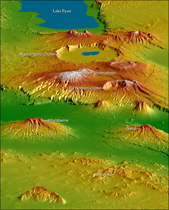
Gelai Volcano also known as Mount Gelai stands at 2,942 metres (9,652 ft) tall[1] and is located in Ngorongoro District, Arusha Region, Tanzania in the Crater Highlands. It is at the southeastern edge of Lake Natron in the East African Rift. Gelai is the third most prominent peak in Arusha Region and is the 13th highest peak in Arusha region.[2] Volcanic activity on Gelai dates to less than one million years ago.[3] A number of earthquakes occurred in the area in the summer of 2007. Associated with the largest earthquake on 17 July a NNE-oriented fracture or narrow graben formed on the southern flank of Gelai. The fracture may be associated with the intrusion of a narrow dike at a depth of around 4,000 metres (13,000 ft).[3]
The volcano falls within a game-controlled area that extends east to Longido District, within Arusha Region, where strict regulated hunting is permitted. This has caused an increase in the numbers of animals in the area due to anti poaching efforts provided by revenue from licensed hunters.[citation needed]
See also
References
External links
- "Gelai". Global Volcanism Program. Smithsonian Institution. Retrieved 2021-06-24.
This Arusha Region location article is a stub. You can help Wikipedia by expanding it. |
На других языках
- [en] Gelai Volcano
[fr] Mont Gelai
Le mont Gelai est un volcan éteint situé au nord de la Tanzanie, dans le massif du Ngorongoro.Другой контент может иметь иную лицензию. Перед использованием материалов сайта WikiSort.org внимательно изучите правила лицензирования конкретных элементов наполнения сайта.
WikiSort.org - проект по пересортировке и дополнению контента Википедии