geo.wikisort.org - Mountains
Ganesh Himāl (Nepali: गणेश हिमाल) is a sub-range of the Himalayas located mostly in north-central Nepal, but some peaks lie on the border with Tibet. The Trisuli Gandaki valley on the east separates it from the Langtang Himal; the Budhi (Buri) Gandaki valley and the Shyar Khola valley on the west separate it from the Sringi Himal and the Mansiri Himal (home of Manaslu, the nearest 8000m peak).[2] The range lies about 70 km north-northwest of Kathmandu.
| Ganesh Himal | |
|---|---|
| गणेश हिमाल | |
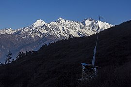
 Ganesh Himal mountain range. Peaks (left to right): unnamed peak (6250 m), Ganesh-II, Pabil, Salasungo | |
| Highest point | |
| Peak | Yangra |
| Elevation | 7,422 m (24,350 ft)[1] |
| Coordinates | 28°23′33″N 85°07′48″E[1] |
| Geography | |
 Ganesh Himal Location in Nepal. | |
| Country | Nepal |
| District | Dhading-Gorkha border |
| Parent range | Himalayas |
| Borders on | Langtang Himal, Sringi Himal and Mansiri Himal |
The highest peak in the range is Yangra (Ganesh I), 7,422 m (24,350 ft). There are three other peaks over 7000 metres plus some fourteen others over 6000 metres.[2] Ganesh Himal enjoys great vertical relief over nearby valleys, particularly Ganesh NW (see below), being closest to the Shyar Khola.
The name for the range comes from the Hindu deity Ganesha, usually depicted in the form of an elephant. In fact, the south face of Pabil (Ganesh IV) slightly resembles an elephant, with a ridge that is reminiscent of an elephant's trunk.
Names and elevations for this range differ from source to source; see the notes below the table. The least ambiguous way to refer to the different peaks would be "Ganesh NW", etc., but this is not the standard practice in the literature for this range.
First ascent of Ganesh I happened on October 6th, 1955. Summit group was conformed by famous guide Raymond Lambert, Pierre Vittoz, Eric Gauchar, all of them Swiss, and French Mme. Claude Kogan.[3]
Highest peaks
| Mountain | Height (m) | Height (ft) | Coordinates | Prominence (m) | Parent mountain | First ascent |
|---|---|---|---|---|---|---|
| Yangra (Ganesh I/Main/NE) | 7,422 | 24,350 | 28°23′33″N 85°07′48″E | 2,352 | Manaslu | 1955 |
| Ganesh II/NW | 7,118 | 23,353 | 28°22′45″N 85°03′24″E | 1,198 | Yangra | 1981 |
| Salasungo (Ganesh III/SE) | 7,043 | 23,107 | 28°20′06″N 85°07′18″E | 641 | Ganesh IV | 1979 |
| Pabil (Ganesh IV/SW) | 7,104 | 23,307 | 28°20′45″N 85°04′48″E | 927 | Ganesh II | 1978 |
Gallery
 Ganesh Mountain range seen from Chandanbari, Rasuwa
 Ganesh Mountain Range seen from Chandragiri
 Ganesh Mountain range seen from Mu-Kharka, Rasuwa
 Ganesh Himal seen from Helambu


Notes
- ^ The names Ganesh II, Salasungo (Ganesh III), and Pabil (Ganesh IV) are from the Finnmap[4] They do not agree with other, older sources such as Carter[2][5] or Neate[6] (which is derived from Carter). Ohmori[7] attests the name "Lapsang Karbo" for the southeast peak, here called Salasungo.
- ^ Heights are from the Finnmap.[4]
- ^ Coordinates have been derived from the Finnmap by Eberhard Jurgalski.
- ^ Prominence values (except for Yangra) have been derived from the Finnmap by Eberhard Jurgalski. For Yangra, the value is from peaklist.org.[1]
- Location Dhading
References
- "Tibet Ultra-Prominences". peaklist.org. Retrieved 3 January 2015.
- Carter, H. Adams (1985). "Classification of the Himalaya" (PDF). American Alpine Journal. American Alpine Club. 27 (59): 124. Retrieved 1 May 2011.
- "American Alpine Journal 1956". AAJO. American Alpine Club. Retrieved 17 December 2016.
- Finnmap topographic map of the Ganesh Himal, produced for the Government of Nepal.
- American Alpine Journal 1989, p. 210.
- Neate, Jill (1989). High Asia: An Illustrated History of the 7000 Metre Peaks. The Mountaineers. ISBN 978-0898862386.
- Ohmori, Koichiro (1994). Over The Himalaya. Cloudcap Press (The Mountaineers). ISBN 978-0938567370.
External links
- Himalayan Index
- DEM files for the Himalaya (Corrected versions of SRTM data)
- Pictures of ganesh himal
На других языках
[de] Ganesh Himal
Der Ganesh Himal ist ein Gebirgsmassiv im Zentral-Himalaya, 75 km nordnordwestlich von Kathmandu, an der Grenze zwischen Nepal und der Volksrepublik China.- [en] Ganesh Himal
[fr] Ganesh Himal
Le Ganesh Himal est un massif du haut Himalaya. Il est principalement situé au Népal (centre-nord), néanmoins quelques sommets se trouvent au Tibet. La vallée de Trisuli à l'est, creusée par la rivière Bothe Khosi, le sépare du Langtang Himal. La vallée de Budhi Gandaki et la vallée de Shyar Khola à l'ouest le séparent du Sringi Himal et du Mansiri Himal (Manaslu).[ru] Ганеш-Гимал
Ганеш-Гимал (непальск. गणेश हिमाल) — горный массив в Гималаях, расположен на границе Непала с Китаем (Тибетский автономный район), примерно в 70 км северо-западнее Катманду. В состав массива входят четыре вершины высотой более 7000 метров и четырнадцать, превышающих 6000 метров [1].Другой контент может иметь иную лицензию. Перед использованием материалов сайта WikiSort.org внимательно изучите правила лицензирования конкретных элементов наполнения сайта.
WikiSort.org - проект по пересортировке и дополнению контента Википедии