geo.wikisort.org - Mountains
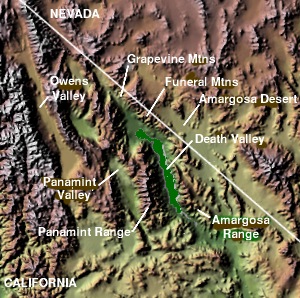
The Funeral Mountains are a short, arid mountain range in the United States along the California-Nevada border approximately 100 mi (160 km) west of Las Vegas. The mountains are considered a subrange of the Amargosa Range that form the eastern wall of Death Valley.
| Funeral Mountains | |
|---|---|
 Pyramid Peak seen from Ash Meadows in Nevada | |
| Highest point | |
| Elevation | 2,043 m (6,703 ft) |
| Geography | |
 Location of Funeral Mountains in California[1] | |
| Country | United States |
| State | California |
| District | Inyo County |
| Range coordinates | 36°23′30″N 116°36′43″W |
| Topo map | USGS East of Echo Canyon |
The crest of the range is within Death Valley National Park. The range is separated from the Grapevine Mountains to the northwest by the narrow Boundary Canyon[2] and is separated from the Black Mountains by Furnace Creek Wash on the southwest and from the Greenwater Range at the narrow Travertine Point on the south.[3] The broad flats of the Amargosa Desert lie across the border to the northeast in Nevada.[2] The highest point in the range is Pyramid Peak, at 6703 ft (2043 m).[4][5]
The first movement of Ferde Grofé's Death Valley Suite is a symphonic musical portrayal of pioneer settlers trudging through the dry craggy peaks of the Funeral Mountains.

References
- "Funeral Mountains". Geographic Names Information System. United States Geological Survey. Retrieved 2009-05-03.
- Beatty, Nevada–California, 30x60 Minute Topographic Quadrangle, USGS, 1986
- Death Valley Junction, California Nevada, 30x60 Topographic Quadrangle, USGS, 1986
- "Pyramid Peak". Geographic Names Information System. United States Geological Survey. Retrieved 2009-05-03.
- East of Echo Canyon, Calif.–Nev., 7.5 Minute Topographic Quadrangle, USGS, 1987
External links
Authority control | |
|---|---|
| General |
|
| National libraries | |
This Inyo County, California-related article is a stub. You can help Wikipedia by expanding it. |
Другой контент может иметь иную лицензию. Перед использованием материалов сайта WikiSort.org внимательно изучите правила лицензирования конкретных элементов наполнения сайта.
WikiSort.org - проект по пересортировке и дополнению контента Википедии