geo.wikisort.org - Mountains
The Grapevine Mountains are a mountain range located along the border of Inyo County, California and Nye County, Nevada in the United States. The mountain range is about 22 miles (35 km) long and lies in a northwest-southeasterly direction along the Nevada-California state line. The range reaches an elevation of 8,738 feet (2,663 m) at Grapevine Peak, near Phinney Canyon on the Nevada side. Daylight Pass is at the southern end of the range. Most of the Grapevine Mountain chain is in Death Valley National Park.
| Grapevine Mountains | |
|---|---|
 Grapevine Mountains | |
| Highest point | |
| Peak | Grapevine Peak |
| Elevation | 2,664 m (8,740 ft) |
| Geography | |
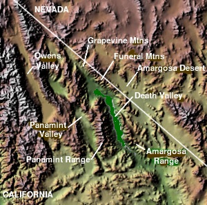
 Location of Grapevine Mountains along the border of California and Nevada[1] | |
| Country | United States |
| State | California and Nevada |
| District | Inyo County and Nye County |
| Range coordinates | 36°57′54.778″N 117°8′57.242″W |
| Topo map | USGS Grapevine Peak |
The range was named for the wild grapes in the area.[2]
References
- "Grapevine Mountains". Geographic Names Information System. United States Geological Survey. Retrieved 2009-05-04.
- Federal Writers' Project (1941). Origin of Place Names: Nevada (PDF). W.P.A. p. 32.
- Allan, Stuart (2005). California Road and Recreation Atlas. Benchmark Maps. p. 81. ISBN 0-929591-80-1.
See also
- Mountain ranges of the Mojave Desert
This Inyo County, California-related article is a stub. You can help Wikipedia by expanding it. |
Текст в блоке "Читать" взят с сайта "Википедия" и доступен по лицензии Creative Commons Attribution-ShareAlike; в отдельных случаях могут действовать дополнительные условия.
Другой контент может иметь иную лицензию. Перед использованием материалов сайта WikiSort.org внимательно изучите правила лицензирования конкретных элементов наполнения сайта.
Другой контент может иметь иную лицензию. Перед использованием материалов сайта WikiSort.org внимательно изучите правила лицензирования конкретных элементов наполнения сайта.
2019-2026
WikiSort.org - проект по пересортировке и дополнению контента Википедии
WikiSort.org - проект по пересортировке и дополнению контента Википедии