geo.wikisort.org - Mountains
The Escambray Mountains (Spanish: Sierra del Escambray) are a mountain range in the central region of Cuba, in the provinces of Sancti Spíritus, Cienfuegos and Villa Clara.
| Escambray | |
|---|---|
 South side of Escambray in Sancti Spíritus Province with Valley of the sugar mills at the front. | |
| Highest point | |
| Peak | Pico San Juan |
| Elevation | 1,140 m (3,740 ft) [citation needed] |
| Coordinates | 21°59′25.08″N 80°8′50.28″W |
| Geography | |
 Location of Escambray Mountains in Cuba | |
| Country | Cuba |
| Provinces | Villa Clara, Cienfuegos and Sancti Spíritus |
| Range coordinates | 21°59′05″N 80°07′57″W |
Overview
The Escambray Mountains are located in the south-central region of the island, extending about 80 kilometers (50 mi) from east to west, and 80 kilometers (50 mi) from north to south.[1] Their highest peak, Pico San Juan, rises to 960 m (3,150 ft)[citation needed] above sea level. The Escambray range is divided into two sections by the Agabama River. The western part is called the Guamuhaya Mountains, and the eastern part, raising between Trinidad and Sancti Spiritus, is best known as Sierra de Sancti Spíritus. After Pico San Juan, the highest points are Caballete de Casas, Gavilanes, Loma de Banao, Caja de Agua, and Pico Tuerto.
Topes de Collantes is a nature reserve park established in the south-eastern ranges of Escambray Mountains, protecting and showcasing caves, rivers, waterfalls, and canyons. The Valley de los Ingenios is developed at the south-eastern foot of the mountains, and is a UNESCO World Heritage Site.
The mountains were the theater of the Escambray Rebellion in 1959–1965. It was also a planned refuge during the Bay of Pigs Invasion, however, it was never used as such.
Gallery
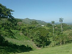 Escambray near Hanabanilla lake in Villa Clara Province
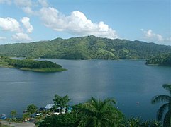 The Hanabanilla lake is at 364 meters over sea level and averages 40 meters deep.
 Tropical rain forest near in the heart of Topes de Collantes, Sancti Spíritus Province
 La Boca fisherman's village near Trinidad with Escambray at the back
 Hanabanilla lake wall, in the village of Jibacoa, in Villa Clara, Escambray.


See also
- Geography of Cuba
References
- Bell, Lydia (24 November 2018). "Cuba libre: exploring the island by campervan" – via www.theguardian.com.
External links
![]() Media related to Escambray Mountains at Wikimedia Commons
Media related to Escambray Mountains at Wikimedia Commons
Mountain ranges of Cuba | |||
|---|---|---|---|
На других языках
[de] Escambray
Das Escambray-Gebirge liegt in Zentral-Kuba, südlich von Santa Clara. Höchste Erhebung des auch Macizo de Guamuhaya (von spanisch macizo „massiv“) genannten Gebirges ist der Berg San Juan mit einer Höhe von 1156 Metern über dem Meeresspiegel.- [en] Escambray Mountains
[es] Escambray
El Escambray, también llamado Macizo Guamuhaya, es un sistema montañoso situado en las provincias de Sancti Spíritus, Villa Clara y Cienfuegos, en la zona central de Cuba. Su punto más alto es el Pico San Juan que alcanza una elevación de 1.140 metros. A sus pies se encuentra la ciudad de Trinidad. Es el tercer sistema montañoso en importancia de la isla de Cuba, después de la Sierra Maestra y el sistema montañoso de Guaniguanico.[fr] Escambray
L'Escambray ou massif de Guamuhaya est une région montagneuse située dans les provinces de Sancti Spíritus, Villa Clara et Cienfuegos, au centre de Cuba. Son point culminant est le pic San Juan qui atteint 1 156 mètres d'altitude. Foyer de l'insurrection au cours de la révolution cubaine, son nom est étroitement associé à celui de Che Guevara qui y installa son campement en 1958 et aux rébellions anti-castristes entre 1959 et 1965.[it] Monti Escambray
I monti Escambray sono una catena montuosa che si trova nella parte centro-meridionale dell'isola di Cuba nelle provincie di Sancti Spíritus, Villa Clara e Cienfuegos.[ru] Эскамбрай
Эскамбрай (исп. Escambray) — горный массив на острове Куба, на территориях провинций Вилья-Клара, Сьенфуэгос, Санкти-Спиритус. Третья по значимости горная система Кубы, после хребтов Сьерра-Маэстра и Гуанигуанико.Другой контент может иметь иную лицензию. Перед использованием материалов сайта WikiSort.org внимательно изучите правила лицензирования конкретных элементов наполнения сайта.
WikiSort.org - проект по пересортировке и дополнению контента Википедии