geo.wikisort.org - Mountains
Dhosi Hill is an important Vedic period site, an extinct volcano, standing alone at the north-west end of the Aravalli mountain range. Its height varies from about 345 to 470 meters from the surrounding lands and 740 meters from the sea level. At present the hill has temples, a pucca pond, ruins of a fort, caves and forest around it. In the ancient times, as per various scriptures like Mahabharata - Vanparv, Puranas, Shathpath Brahmana etc. the hill had Ashrams of various Rishis who made contributions to Vedic scriptures.
This article needs additional citations for verification. (December 2014) |
| Dhosi Hill | |
|---|---|
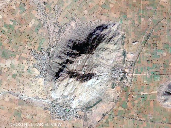 Aerial view of Dhosi Hill showing ancient 'Parikrama' | |
| Highest point | |
| Elevation | 740 m (2,430 ft) |
| Listing | List of Indian states and territories by highest point |
| Coordinates | 28°03′40″N 76°01′55″E |
| Geography | |
 Dhosi Hill Location in Haryana  Dhosi Hill Dhosi Hill (India) | |
| Location | Mahendragarh district, Haryana, India |
| Parent range | Aravali Range |
| Climbing | |
| Easiest route | Hike / scramble |
The hill has all the physical features of a perfect volcanic hill with distinct crater, lava still lying on it and giving a perfect conical view from top.[citation needed]
It is among the most ancient Vedic religious sites in Haryana located on the route of oldest flow of Saraswati river. It is known for formulation of Chyvanprash for Chayvan Rishi by Rajya Vaids Ashvini Kumar twins for the first time. Chyavana Rishi and his father Bhrugu Rishi had their Ashrams on this hill. Yats
Location
 View of Dhosi Hill crater showing various structures
 Lava or eruptions lying at Hill


Dhosi Hill is located on the borders of the Indian states of Haryana and Rajasthan. The Haryana portion lies in Mahendragarh district to the south, 5 kilometres (3.1 mi) from Narnaul on Singhana Road; the Rajasthan portion lies in Jhunjhunu district to the north.
While the ground level is about 900 feet (270 m) above sea level, the hilltop is another 900 feet above the ground level.
 Serpentine Stairs to Dhosi Hill Crater from Kultajpur side
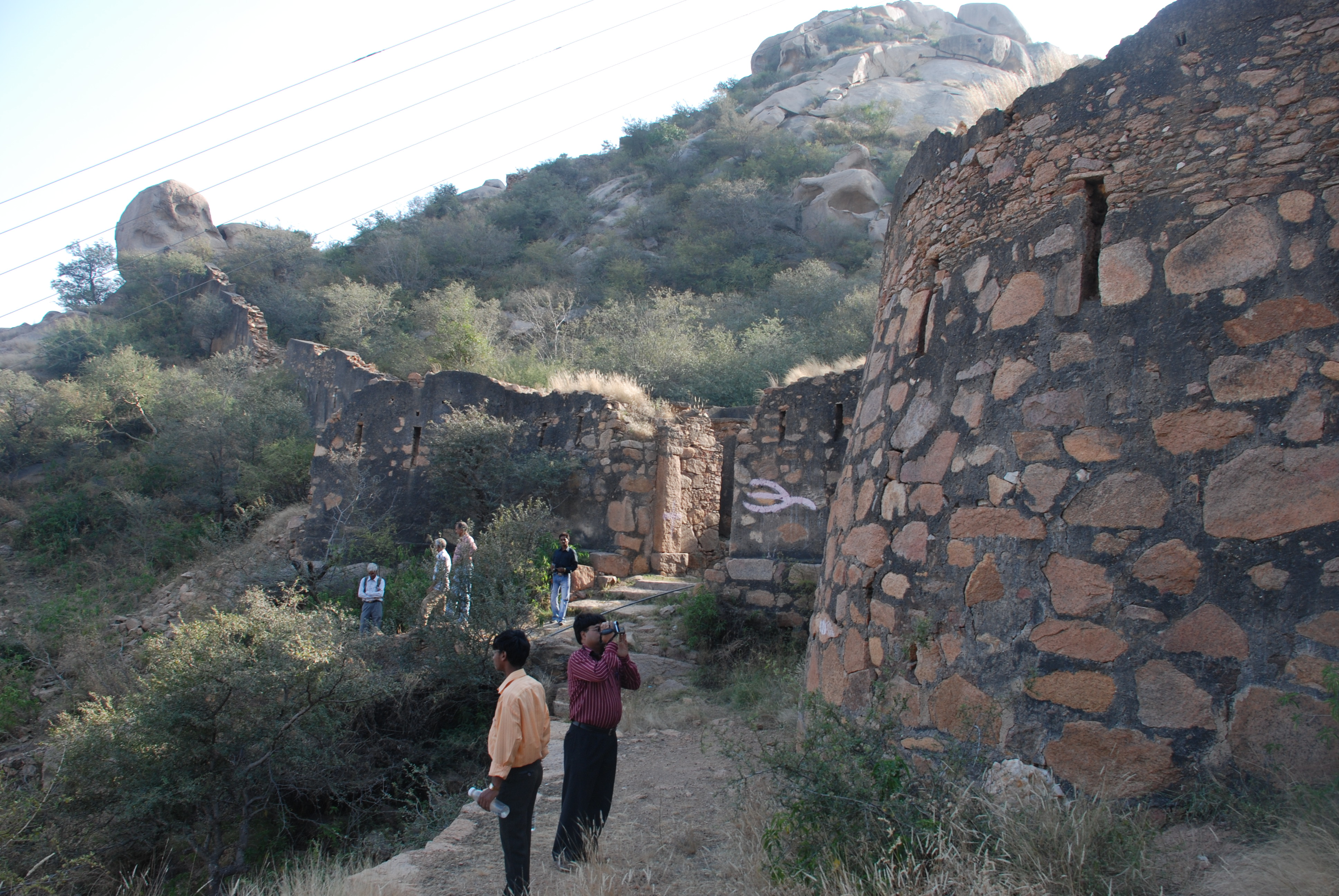
 Remnants of a fort built during medieval period by Hemu
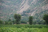 Base of Dhosi Hill
 Shiv Kund' Sarovar at Dhosi Hill
 Cave on the route of parikrama, which provides shelter to pilgrims
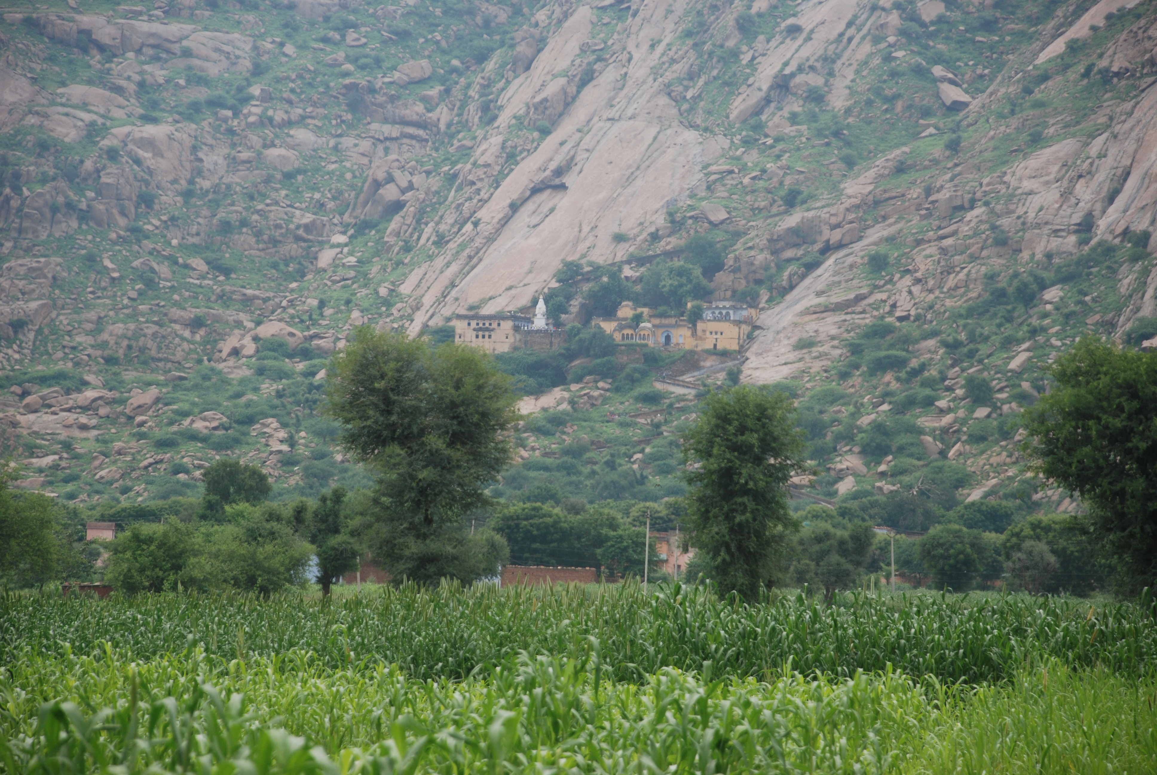
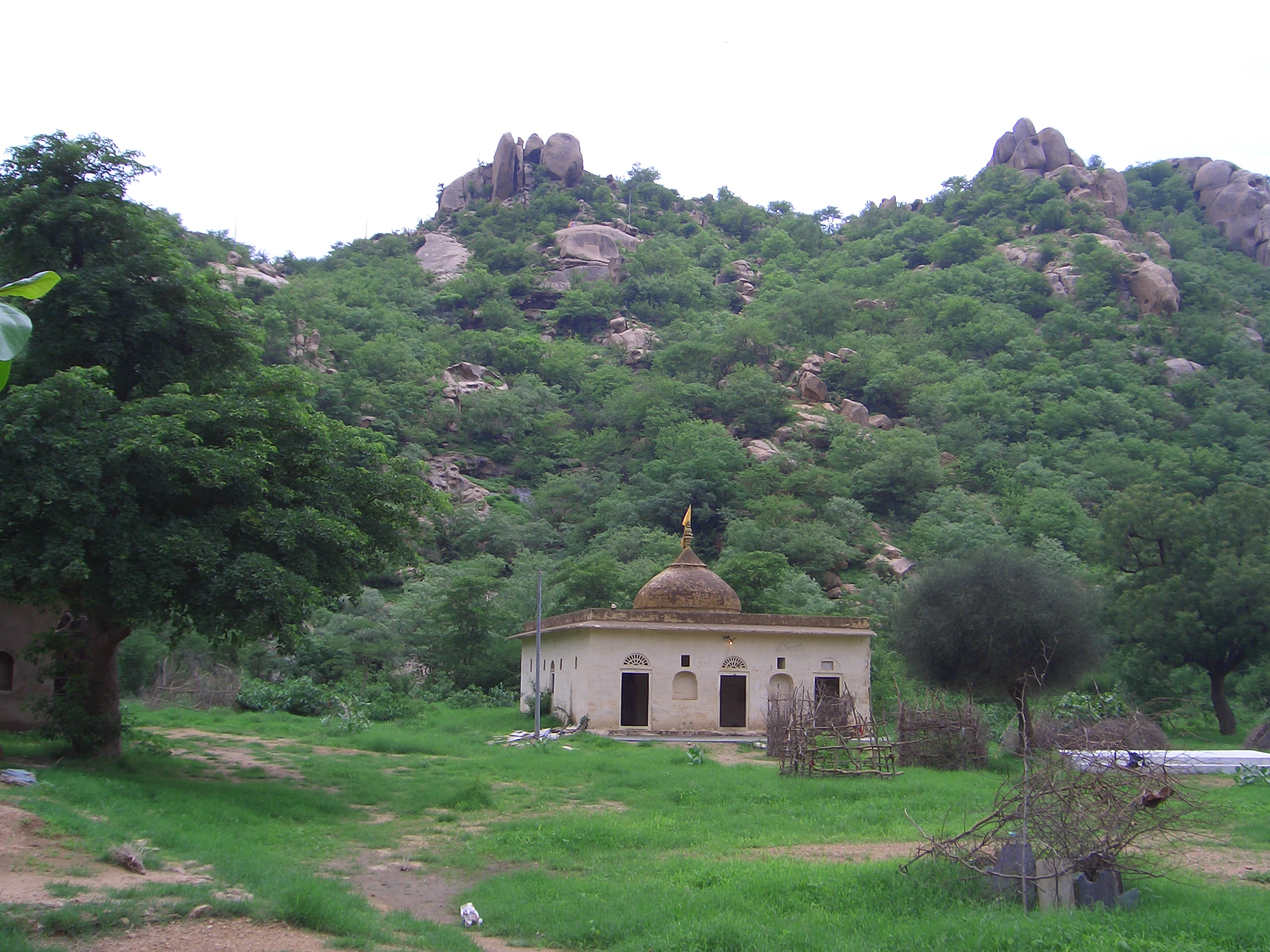
 Ancient Shiva Temple on the levelled surface of the hill


Importance
As per Manusmriti, this hill is part of the Vedic state of 'Brahmavarta' the land between ancient Saraswati river and Drishadwati rivers [1] which was also called 'Devbhumi'. This being a volcanic hill had erupted on the banks of a river Drishadvati, which had its origin in Aravalli mountains, from Lord Brahma's abode at Pushkar Lake near Ajmer. Even at present times, water from Jaipur district in Rajasthan flows in the ancient river Drishadwati river. According to research by 'Brahmavarta Research foundation', [2] Rewari, the main Vedic scriptures like Manusmriti, Vedas and Upnishads were evolved and composed in this area called the Manu's state of Brahmavarta, where Rishis and Munis had their Ashrams. Lord Manu, Rishis like Bhrigu, Chyavana, Durvasa, Piplad etc., who have contributed to various Sanskriti scriptures, had their Ashrams in the vicinity, 50 KMtrs radius of this hill.
Administration
The hill presently falls under the administration of three village panchayats, being those of Dhosi in Jhunjhunu district of Rajasthan state and of Thana and Kultajpur in Mahendragarh district of Haryana state.[citation needed] These villages are situated on the three waterfalls that become active during the monsoons that occur in July–August, being created from the overflow of a reservoir at the summit. The waterfalls are mentioned in the epic Mahabharata. Each village also has an ancient water reservoir to augment the supply for villagers and animals.[citation needed]
Fort on the Hill
Dhosi Hill has remnants of a fort built by Hemu about 500 years ago. There are thick walls, up to 25 feet (7.6 m) high and 40 feet (12 m) wide on even the steepest slopes and the top of the volcano. The fort was constructed to safeguard the heritage and ashrams on the hill from frequent attacks by Muslim invaders during the medieval period. To replace the old temple, a fort modeled on the temple of Chyavana was built at the crater of the hill in the 1890s by the Bhargava community.
All-weather stairs in stone and lime plaster are constructed on the Kultajpur and Thana sides.
Water sources

A sarovar (reservoir) that stores rainwater for bathing of pilgrims has existed at the summit of the hill for centuries. The stored water is claimed to contain a few rejuvenating properties and treatment for skin ailments. The water in the reservoir becomes herbal and also cupric because of the quantity of copper in the hill and growth of rare herbs in large quantities.
The reservoir becomes silted over time and is desilted at regular intervals. In 1944, the industrialists Birla brothers, led by G. D. Birla, who hailed from the nearby Pilani village, arranged for the reservoir to be desilted and constructed a proper concrete dam on the site to increase the storage capacity. This was done in the memory of their father, Raja Baldev Rai Birla. A plaque is put on the Dam to this effect which states that reservoir could be used for bathing by all shades of Hindu pilgrims, including Sanatani, Harijan, Arya Samaji, Buddhists, Jains and Sikhs. This plaque shows that there was no caste barrier to use of the facilities.[citation needed]
In 2003, the reservoir was desilted by Indian National Trust for Art and Cultural Heritage, an NGO based in Delhi and Haryana.[citation needed]
A well for the supply of water for drinking and other purposes exists on the top of hill which is recharged by seepage and percolation of water from adjoining reservoirs which are charged by the rainwater on the hill. The Government of Haryana now provides drinking water at the hill through mechanical uplifting from the base of the hill.[citation needed]
Parikrama
Those visiting the hill on pilgrimage perform a parikrama (circumambulation) of it since the time of Mahabharata and Guru Shaunaka of Pandavas. The 8–9 KMs parikrama track includes some portions which are damaged because of landslides.
Temples and religious melas
Apart from temples at Shiv Kund, halfway to top of hill from Kultajpur side, there are several temples on the crater portion of the hill. Among these is the Chyavana temple, the Shiva temple on the crater, a Devi temple on the hilltop, and a Rama temple next to the Royal Guest House. The Chyavana temple has Shekhawati paintings in the Garbhagrah of the temple and a basement which can be used as a Dharmshala (resting place) for pilgrims. Among other structures on the hill is the renovated Chandrakoop.
Melas are organised at various festivals and other special days. On the day of Somvati Amavasya many people assemble for a holy bath in the sarovars. A map from the 1890s indicates there were then separate Ghats for women, known as Janana Ghats, but now they are abandoned.
See also
- Delhi Ridge
- Leopards of Haryana
- Karoh Peak, Panchkula district, highest point in Haryana, 1467 m peak
- Morni Hills, Panchkula district, 1267 m peak
- Tosham, 240 m average elevation
- Madhogarh, Haryana, 214 m average elevation
- Monuments of National Importance in Haryana
- State Protected Monuments in Haryana
- National Parks & Wildlife Sanctuaries of Haryana
- India cave temples
- Caves in India
- Rock-cut temples in India
- Indian rock-cut architecture
- Chyavana Rishi
- Indus Valley Civilisation sites
- Highest point of Indian states and territories
- List of mountains in India
- Haryana Tourism
References
- Manu Smriti, Translated by Pt. Tulsi Ram Swami, published by 'Sarvdeshic Arya Sabha' New Delhi, Chapter 2, Shalok No. 17, page 74.
- Sudhir Bhargava, 'Location of BRAHMAVARTA and DRISHADWATI river is important to find the true alignment of Vedic Saraswati river', Saraswati River: International Conference, 20-22 Nov. 2009, at Kurukshetra University, Kurukshetra.
Capital: Chandigarh | |||||||||||||||||||||||||||||||||||||||||||||||
| Topics |
| ||||||||||||||||||||||||||||||||||||||||||||||
| Districts and divisions |
| ||||||||||||||||||||||||||||||||||||||||||||||
| Major cities | |||||||||||||||||||||||||||||||||||||||||||||||
| Culture |
List of films, Chandrawal, Jagat Jakhar)
| ||||||||||||||||||||||||||||||||||||||||||||||
| Economy |
| ||||||||||||||||||||||||||||||||||||||||||||||
| |||||||||||||||||||||||||||||||||||||||||||||||
| |||||||||||||||||||||||||||||||||||||||||||||||
| |||||||||||||||||||||||||||||||||||||||||||||||
| |||||||||||||||||||||||||||||||||||||||||||||||
Protected areas of Haryana | ||
|---|---|---|
| National Parks |  | |
| Wildlife Sanctuaries |
| |
| Conservation Reserves |
| |
| Deer Parks | ||
| Zoo |
| |
| Breeding Centres |
| |
| ||
Protected areas of India | ||
|---|---|---|
|  | |
| ||
National parks of India | ||||||||||||||||||||||||||||||||||||||||
|---|---|---|---|---|---|---|---|---|---|---|---|---|---|---|---|---|---|---|---|---|---|---|---|---|---|---|---|---|---|---|---|---|---|---|---|---|---|---|---|---|
| ||||||||||||||||||||||||||||||||||||||||
| ||||||||||||||||||||||||||||||||||||||||
| ||||||||||||||||||||||||||||||||||||||||
| ||||||||||||||||||||||||||||||||||||||||
Другой контент может иметь иную лицензию. Перед использованием материалов сайта WikiSort.org внимательно изучите правила лицензирования конкретных элементов наполнения сайта.
WikiSort.org - проект по пересортировке и дополнению контента Википедии