geo.wikisort.org - Mountains
The Dent de Crolles (French pronunciation: [dɑ̃ də kʁɔl]) is a karstic mountain (2,062 m) of the Chartreuse Mountains range, 17 kilometres (11 miles) north east of Grenoble, Isère, France. It has a characteristic "tooth-like" profile and is easily recognizable in the Isère Valley (Grésivaudan) in the Grenoble area. The French word "dent" means tooth and "de Crolles" is derived from the town of Crolles, located next to the mountain.
| Dent de Crolles | |
|---|---|
 The Dent de Crolles seen from Saint-Pancrasse (South) | |
| Highest point | |
| Elevation | 2,062 m (6,765 ft) |
| Prominence | 681 m (2,234 ft)[1] |
| Coordinates | 45°18′30″N 5°51′19″E |
| Geography | |
 Dent de Crolles Location in the Alps  Dent de Crolles Dent de Crolles (France) | |
| Country | France |
| Department | Isère |
| Parent range | Chartreuse Mountains |
| Climbing | |
| Easiest route | From the Col du Coq |
Geography
The Dent de Crolles is a karstic mountain (2,062 m) of the Chartreuse Mountains range, 17 kilometres (11 miles) north east of Grenoble, Isère, France.[2] The French word "dent" means tooth and "de Crolles" is derived from the town of Crolles, located next to the mountain. It is easily recognizable from the Val-d´Isère (Grésivaudan) in the Grenoble area.
Cave system
The réseau de la Dent de Crolles, which lies beneath the summit plateau, is one of the most complex and longest cave systems in Europe, and is considered[according to whom?] to be one of the birth places of modern caving. Its first detailed exploration was during World War II by a small team of French cavers which included Pierre Chevalier, Fernand Petzl, and Charles Petit-Didier.[3] Their explorations saw it become the deepest cave in the world at the time with a depth of −658 m (−2,159 ft). The lack of available equipment during the war forced the team to develop their own equipment, leading to technical innovation. The first use of the single rope technique with prusik and mechanical rope-ascenders (Henri Brenot's "monkeys", first used by Chevalier and Brenot in a cave in 1934) can be directly associated with its exploration.[4]
Since 1946, the cave has undergone intense and continuous exploration. As of 2022, sixteen separate entrances have been discovered.[5] The highest is the Gouffre Bob Vouay at an altitude of 2,015 metres (6,611 ft) located close to the summit, and the lowest is the main resurgence, the Grotte du Guiers Mort at an altitude of 1,334 metres (4,377 ft), giving a depth of 681 metres (2,234 ft). It is known to include more than 60 kilometres (37 mi) of passages. The cave system is popular for the various through trips that the various entrances allow.[6][7]

Gallery
 Dent de Crolles shot from Biviers.
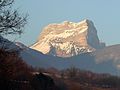 Dent de Crolles taken from Biviers.
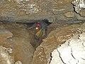 A passage in the Gouffre Bob Vouay - Grotte Chevalier traverse.
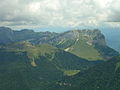 The Dent de Crolles taken from the summit of Chamechaude (south-west).
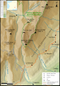 Map of the Dent de Crolles.
 The entrance of the Bob Vouay pothole, the highest entry of the Dent de Crolles network.
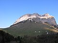 The Dent de Crolles, the col and the habert des Ayes from the col du Coq (south-west).
 The Chevalier cave from the inside.
 From the summit, a panorama of the Chartreuse massif: the Lances de Malissard overhanging the col de Bellefond.
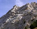 Close up on Dent de Crolles and the French: Poussez Pas Derrière ascent route.
 Entrance to the cave of Guiers Mort, the karst spring of the Dent de Crolles network.
 Cross section of the Dent de Crolles at the Chevalier cave.
 Pitch into the Dent de Crolles.
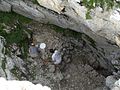 The Bob Vouay pothole.
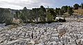 Limestone pavement of la Dent de Crolles.
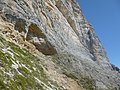 Entrance to the cave Chevalier.
 Entrance to the cave Annette.
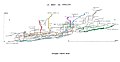 On the cross-section are represented the main crossings: in light green Glaz-Annette, in dark green Glaz-Chevalier, in blue P40-Glaz, in orange Glaz-Guiers Mort, in blue Glaz-Guiers Mort by the river, in yellow Thérése-Guiers, in red Cartusiens-Guiers, in purple Pulpite Irreversible-Glaz. Other crossings can be made: Bob Vouay-Glaz or Guiers but they are not coloured.
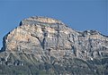 Caves of the East face: Grotte Annette, grotte Chevalier, Maxi Méga Marmotte, le Sureau, l'Entrée des Artistes, les Excités, le Balcon, le nid de Choucas, grotte Petzl, la grotte des Montagnards et la grotte du Jibé.
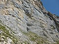 Cave Petzl separated by a boulder choke from the network of the Dent de Crolles.
 Entrance of Trou du Glaz.
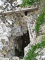 The pothole of Pulpite.
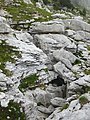 The P40.
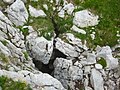 Therese's cave.


Bibliography (in French)
- La Dent de Crolles et son réseau souterrain, Comité départemental de spéléologie de l'Isère, 1997, ISBN 2-902670-38-9 : "La Dent de Crolles et son réseau souterrain" (PDF).
References (in French)
- Site géologique
- Groupe Montagnard des Petites Roches : informations sur le site d'escalade du Luisset.
- escalade/ski/randonnée à la Dent de Crolles sur c2c
- Nouvelles topos de la dent de Crolles, Spéléo Secours Isère, 4 janvier 2015.
References
- "Dent de Crolles". Peakbagger.com. Retrieved 4 February 2015.
- "Géoportail".
- "La Dent de Crolles et son réseau souterrain" (PDF). p. 69..
- Courbon, Paul. "Evolution des techniques Spéléologiques/1" (in French). p. 6. Retrieved 1 September 2015.
- "The entrances of réseau de la Dent de Crolles". geoportail.gouv.fr..
- Charreton, Philippe. "Historique". Speleo Dent de Crolles. Archived from the original on 3 March 2016. Retrieved 31 October 2016.
- Gardner, John. "Réseau de la Dent de Crolles". braemoor.co.uk. Retrieved 25 July 2021.
Authority control | |
|---|---|
| General |
|
| National libraries | |
На других языках
[de] Dent de Crolles
Der Dent de Crolles ist ein karstiger Berg (2062 m) des Chartreuse-Massivs, 20 Kilometer nordöstlich von Grenoble (Frankreich) und wurde nach dem naheliegenden Dorf Crolles benannt. Der Berg ist ein Wanderberg und auch von Kletterern und Gleitschirmfliegern besucht. Seine markante Südostseite ragt steil über dem breiten Tal Grésivaudan auf, das Chambery mit Grenoble verbindet. Der Zugang erfolgt üblicherweise vom Col du Coq, einer schmalen Pass-Straße mit einem Scheitel von 1434 m. Kurz darunter ist auch ein großer Wanderparkplatz. Nach dem Aufstieg zum Col des Ayes über Almwiesen führen die Wege entweder nach Nordosten um den Berg herum zum Trou de Glaz (s. u.) und über einige seilgesicherte Felsstufen zum Pas de Glaz (hier zweigt der Wanderweg GR 9 durch die Chartreuse ab). Auf der verkarsteten schrägen Hochebene zieht der Weg dann zum Gipfel. Der alternative Weg trennt sich knapp über dem Col des Ayes über geht dann nach Osten direkt zum Gipfel. Dieser Weg ist sehr steil und hat ebenfalls seilgesicherte Felsstufen. Eine weitere Alternative ist der Sangle de la Barrère, eine recht luftige Wegstrecke auf einem knappen Felsband vom Pas de Glaz nach Süden fast zum Gipfel.- [en] Dent de Crolles
[fr] Dent de Crolles
La dent de Crolles est un sommet du département français de l'Isère s'élevant à 2 062 mètres d'altitude dans le massif de la Chartreuse, dans les Alpes. Elle domine à l'est la ville de Crolles et la vallée du Grésivaudan, à moins d'une heure de Grenoble. Elle est constituée de calcaire et parcourue par un important réseau karstique, qui attire la curiosité de Henri Ferrand dès le tournant du XIXe au XXe siècle ; son exploration en fait la cavité naturelle la plus profonde connue au monde de 1944 à 1953. Il est recherché des spéléologues, avec de nombreuses traversées souterraines possibles. La source du Guiers Mort, sur le versant septentrional de la montagne, est l'exsurgence de ce réseau. L'ascension de la montagne, généralement effectuée depuis le col du Coq, ne présente pas de difficulté en randonnée pédestre. Depuis les années 1920, le nombre de voies d'escalade s'est considérablement accru.[it] Dent de Crolles
Il Dent de Crolles (2.062 m s.l.m.) è una montagna delle Prealpi della Chartreuse nelle Prealpi di Savoia.Другой контент может иметь иную лицензию. Перед использованием материалов сайта WikiSort.org внимательно изучите правила лицензирования конкретных элементов наполнения сайта.
WikiSort.org - проект по пересортировке и дополнению контента Википедии