geo.wikisort.org - Mountains
Dallol is a unique, terrestrial hydrothermal system around a cinder cone volcano in the Danakil Depression, northeast of the Erta Ale Range in Ethiopia. It is known for its unearthly colors and mineral patterns, and the very acidic fluids that discharge from its hydrothermal springs.[1]
| Dallol | |
|---|---|
 | |
| Highest point | |
| Elevation | −48 m (−157 ft) |
| Coordinates | 14°14′30″N 40°18′00″E |
| Geography | |
 Dallol Location within Ethiopia | |
| Location | Ethiopia |
| Parent range | Danakil Depression |
| Geology | |
| Mountain type | Explosion craters |
| Last eruption | 2011 |

Etymology
The term Dallol was coined by the Afar people and means dissolution or disintegration, describing a landscape of green acid ponds and geysers (pH-values less than 1) and iron oxide, sulfur and salt desert plains. The area somewhat resembles the hot springs areas of Yellowstone National Park.
Description
Dallol mountain has an area of about 3 by 1.5 km (1.9 by 0.9 mi), and rises about 60 m (196.9 ft) above the surrounding salt plains. A circular depression near the centre is probably a collapsed crater. The southwestern slopes have water-eroded salt canyons, pillars, and blocks. There are numerous saline springs and fields of small fumaroles.[2]
Numerous hot springs discharge brine and acidic liquid here.[3] Small, widespread, temporary geysers produce cones of salt. The Dallol deposits include significant bodies of potash found directly at the surface.[4] The yellow, ochre and brown colourings are the result of the presence of iron and other impurities. Older, inactive springs tend to be dark brown because of oxidation processes.[2]
Formation
It was formed by the intrusion of basaltic magma into Miocene salt deposits and subsequent hydrothermal activity.[5] Phreatic eruptions took place here in 1926, forming Dallol Volcano; numerous other eruption craters dot the salt flats nearby. These craters are the lowest known subaerial volcanic vents in the world, at 45 m (148 ft) or more below sea level. In October 2004 the shallow magma chamber beneath Dallol deflated and fed a magma intrusion southwards beneath the rift.[6] The most recent signs of activity occurred in January 2011 in what may have been a degassing event from deep below the surface.[7]
Physical properties
Dallol lies in the evaporitic plain of the Danakil depression at the Afar Triangle, in the prolongation of the Erta Ale basaltic volcanic range.[8] The intrusion of basaltic magma in the marine sedimentary sequence of Danakil resulted in the formation of a salt dome structure, where the hydrothermal system is hosted.[9][10] The age of the hydrothermal system is unknown and the latest phreatic eruption that resulted in the formation of a 30 m (98 ft) diameter crater within the dome, took place in 1926.[11] The wider area of Dallol is known as one of the driest and hottest places on the planet.[12] It is also one of the lowest land points, lying 125 m (410 ft) below mean sea level. Other known hydrothermal features nearby Dallol are Gaet'Ale Pond[13] and Black Lakes.[1]
The hydrothermal springs of Dallol discharge anoxic, hyper-acidic (pH <0), hyper-saline (almost 10 times more saline than seawater), high temperature (> 108 °C (226 °F)) brines that contain more than 26 g/L of iron.[1] The main gases emitted from the springs and fumaroles are carbon dioxide, hydrogen sulfide, nitrogen, sulfur dioxide; and traces of hydrogen, argon, and oxygen.[14] Although several other hyper-acidic (pH <2) volcanic systems exist, mainly found in crater lakes and hydrothermal sites, the pH values of Dallol decrease far below zero.[1] The coexistence of such extreme physicochemical characteristics (pH, salinity, high temperature, lack of oxygen, etc.) render Dallol one of the very few ‘poly-extreme’ sites on Earth.[1] This is why Dallol is a key system for astrobiological studies investigating the limits of life.[15] Parts of the region are nearly sterile, except for a diverse array of "ultrasmall" archaea.[16]

Dallol is highly dynamic; active springs go inactive and new springs emerge in new places in the range of days and this is also reflected in the colors of the site that change with time from white to green, lime, yellow, gold, orange, red, purple and ochre.[17] In contrast to other hydrothermal systems known for their colorful pools (e.g. Grand Prismatic Spring), where the colors are generated by biological activity,[18] the color palette of Dallol is produced by the inorganic oxidation of the abundant iron phases.[1] Another fascinating feature of Dallol is the wide array of unusual mineral patterns, such as, salt-pillars, miniature geysers, water-lilies, flower-like crystals, egg-shaped crusts, and pearl-like spheres. The main mineral phases encountered at Dallol are halite, jarosite, hematite, akaganeite and other Fe-oxyhydroxides, gypsum, anhydrite, sylvite and carnallite.[19]
Absence of life
In October 2019, a French-Spanish team of scientists published an article in Nature Ecology and Evolution[20] that concludes that while the salt plains are teeming with halophile microorganisms, there is no life in Dallol's multi-extreme ponds due to the combination of hyperacidic and hypersaline environments, and the abundance of magnesium (which catalyzes the denaturation of biomolecules).[21]
History
The Dallol area lies up to 120 metres (390 ft) below sea level, and has been repeatedly flooded in the past when waters from the Red Sea have flowed into the depression. The last separation from the Red Sea was about 30,000 years ago.
The discovery of the volcano by the first European settlers certainly dates from the first colonization and expeditions in the region, in the 17th or 18th century. But the hostility of the depression, the unbearable heat which reigns there, and the dangers of the site (acid basins, toxic fumes), did not favour the exploration of the zones close to the crater. On the contrary, the Erta Ale was much more accessible, especially because the part of the rift where it is located (called the Erta Ale Range), is significantly higher. The last eruption of this phreato-magmatic volcano dates back to 2011.[22]
Gallery
 The Danakil desert seen from Dallol
 Salt and sulfur formations at Dallol
 Salt canyons
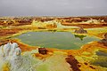 Sulfur ponds
 Guide walking on Dallol


See also
- List of volcanoes in Ethiopia
- Dallol – a ghost town in the Dallol crater. It had the record high average temperature for an inhabited location on Earth.
References
- Kotopoulou, Electra; et al. (2018-12-06). "A poly-extreme hydrothermal system controlled by iron: the case of Dallol at the Afar Triangle". ACS Earth and Space Chemistry. 3 (1): 90–99. doi:10.1021/acsearthspacechem.8b00141. PMC 6380227. PMID 30801049.
- Roscoe, Richard. "Dallol Volcano". PhotoVolcanica.com. Retrieved 21 December 2020.
- Kotopoulou, Electra; Huertas, Antonio Delgado; García-Ruiz, Juan Manuel; Dominguez-Vera, Jose M.; Lopez-Garcia, Jose Maria; Guerra-Tschuschke, Isabel; Rull, Fernando (2018-12-06). "A poly-extreme hydrothermal system controlled by iron: the case of Dallol at the Afar Triangle". ACS Earth and Space Chemistry. 3 (1): 90–99. doi:10.1021/acsearthspacechem.8b00141. PMC 6380227. PMID 30801049.
- "Dallol in March, 2015". Independent Travellers. independent-travellers.com. Retrieved July 3, 2017.
- "Dallol salt springs and geysers". Wondermondo. 2011-06-07.
- Nobile, A; Pagli, C; Keir, D; Wright, TJ; Ayele, A; Ruch, J; Acocella, A (October 2012). "Dike-fault interaction during the 2004 Dallol intrusion at the northern edge of the Erta Ale Ridge (Afar, Ethiopia)" (PDF). Geophysical Research Letters. 39 (19): n/a. Bibcode:2012GeoRL..3919305N. doi:10.1029/2012GL053152. hdl:2158/1110072. S2CID 54908652.
- "Dallol". Global Volcanism Program. Smithsonian Institution.
- Varet, J.; Barberi, F. (1970-12-01). "The Erta Ale volcanic range (Danakil depression, northern afar, ethiopia)". Bulletin Volcanologique. 34 (4): 848–917. Bibcode:1970BVol...34..848B. doi:10.1007/BF02596805. ISSN 1432-0819. S2CID 129118387.
- Nobile, Adriano; et al. (2012-10-16). "Dike-fault interaction during the 2004 Dallol intrusion at the northern edge of the Erta Ale Ridge (Afar, Ethiopia)" (PDF). Geophysical Research Letters. 39 (19): n/a. Bibcode:2012GeoRL..3919305N. doi:10.1029/2012GL053152. hdl:2158/1110072. ISSN 1944-8007. S2CID 54908652.
- Carniel, Roberto; et al. (2010-12-01). "A geophysical multi-parametric analysis of hydrothermal activity at Dallol, Ethiopia". Journal of African Earth Sciences. 58 (5): 812–819. Bibcode:2010JAfES..58..812C. doi:10.1016/j.jafrearsci.2010.02.005. ISSN 1464-343X.
- Lee., Siebert (2010). Volcanoes of the world. Simkin, Tom., Kimberly, Paul. (3rd. ed.). Washington, D.C.: Smithsonian Institution. ISBN 9780520947931. OCLC 787847241.
- Fazzini, Massimiliano; Bisci, Carlo; Billi, Paolo (2015), "The Climate of Ethiopia", World Geomorphological Landscapes, Springer Netherlands, pp. 65–87, doi:10.1007/978-94-017-8026-1_3, ISBN 9789401780254
- Chebude, Yonas; Pérez, Eduardo (2017-04-01). "Chemical Analysis of Gaet'ale, a Hypersaline Pond in Danakil Depression (Ethiopia): New Record for the Most Saline Water Body on Earth". Aquatic Geochemistry. 23 (2): 109–117. doi:10.1007/s10498-017-9312-z. ISSN 1573-1421. S2CID 132715553.
- Darrah, Thomas; et al. (2013-02-15). "Gas chemistry of the Dallol region of the Danakil Depression in the Afar region of the northernmost East African Rift". Chemical Geology. 339: 16–29. Bibcode:2013ChGeo.339...16D. doi:10.1016/j.chemgeo.2012.10.036. ISSN 0009-2541.
- Belilla, Jodie; et al. "Exploring microbial life in the multiextreme environment of Dallol, Ethiopia" (PDF). goldschmidtabstracts.info. Retrieved 2018-12-10.
- Belilla, Jodie (2019). "Hyperdiverse archaea near life limits at the polyextreme geothermal Dallol area". Nature Ecology & Evolution. 3 (November 2019): 1552–1561. doi:10.1038/s41559-019-1005-0. PMC 6837875. PMID 31666740.
- Announcing the winners of the Photo Contest ‘Wonders of Geochemistry’
- Nugent, Paul W.; Shaw, Joseph A.; Vollmer, Michael (2015-02-01). "Colors of thermal pools at Yellowstone National Park". Applied Optics. 54 (4): B128–B139. Bibcode:2015ApOpt..54B.128N. CiteSeerX 10.1.1.727.1559. doi:10.1364/AO.54.00B128. ISSN 2155-3165. PMID 25967819.
- Kotopoulou, Electra; et al. "Geochemistry and mineralogy of the hyper-acidic hydrothermal system of Dallol, Ethiopia" (PDF). goldschmidtabstracts.info. Retrieved 2018-12-10.
- Belilla, Jodie; Moreira, David; Jardillier, Ludwig; Reboul, Guillaume; Benzerara, Karim; López-García, José M.; Bertolino, Paola; López-Archilla, Ana I.; López-García, Purificación (2019). "Hyperdiverse archaea near life limits at the polyextreme geothermal Dallol area". Nature Ecology & Evolution. 3 (11): 1552–1561. doi:10.1038/s41559-019-1005-0. ISSN 2397-334X. PMC 6837875. PMID 31666740.
- "Dallol Geothermal Field — A Place on Earth Where There is No Life". www.indrastra.com. ISSN 2381-3652. Archived from the original on 2019-12-11. Retrieved 2019-12-11.
- "Global Volcanism Program | Dallol".
Bibliography
- On the Volcanoes of the World episode The Horn of Africa (2008; Science Channel)
External links
На других языках
[de] Dallol
Dallol gilt als eines der außergewöhnlichsten Geothermalgebiete der Erde. Das Gebiet liegt in der Danakil-Depression im Nordosten Äthiopiens in Grenznähe zu Eritrea. In dieser schwer erreichbaren Gegend wurden die höchsten durchschnittlichen Jahrestemperaturen der Erde registriert.- [en] Dallol (hydrothermal system)
[es] Dallol
Dallol es un cráter volcánico o maar en la depresión de Danakil, al noreste de la cordillera Erta Ale en Etiopía. Se formó por la intrusión de magma basáltico en los depósitos de sal del Mioceno y la actividad hidrotermal posterior.[1] Las erupciones freáticas ocurrieron en 1926, formando el volcán Dallol, mientras que otros cráteres de erupción salpican los salares cercanos. Estos cráteres son los respiraderos volcánicos subaéreos más bajos del mundo, a 45 metros por debajo del nivel del mar.[fr] Dallol (volcan)
Dallol est un site géologique situé dans le désert du Danakil, au nord-est de l'Éthiopie, à une quinzaine de kilomètres de la frontière de l'Érythrée. Ce site volcanique (solfatarien) se trouve à l'extrémité nord d'un lac salin, le lac Karoum, dont le sel est encore exploité par les Afars. Il résulterait de l'explosion d'une importante chambre magmatique de la vallée du Grand Rift au-dessus d'une vaste zone saline à l'ouest de la mer Rouge, et se trouve à – 136,8 mètres au-dessous du niveau de la mer, dans la dépression de Danakil. La température y atteint régulièrement les 45 degrés à l'ombre. Une réinterprétation géologique du site laisse entendre qu'il ne s'agit nullement d'une activité purement volcanique mais de phénomènes complexes entre dynamique salifère (halocinèse) et circulations hydrothermales[1] possiblement liées à une intrusion en profondeur (bien que cette intrusion n'ait pas été reconnue en géophysique jusqu'à 2 200 m de profondeur)[2].[it] Dallol (vulcano)
Dallol è il nome di una cittadina dell'Afar, ma anche di un cratere vulcanico dalle caratteristiche uniche.[ru] Даллол (вулкан)
Далло́л — действующий вулкан во впадине Данакиль, на северо-востоке Эфиопии, недалеко от границы с Эритреей. Это самый низкий вулкан в мире, не считая подводных. Вулкан известен своими специфическими пейзажами, похожими на внеземные, напоминающими поверхность Ио, спутника планеты Юпитер.Другой контент может иметь иную лицензию. Перед использованием материалов сайта WikiSort.org внимательно изучите правила лицензирования конкретных элементов наполнения сайта.
WikiSort.org - проект по пересортировке и дополнению контента Википедии