geo.wikisort.org - Mountains
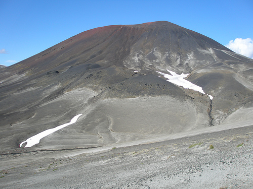
Cocoa Crater is a cinder cone in the Stikine Country of northwestern British Columbia, Canada. It is located 38 km southeast of Telegraph Creek and 8 m (26 ft) southwest of Mount Edziza. Cocoa Crater is one of the 30 cinder cones around the Mount Edziza complex that formed in the year 700. The ash around Cocoa Crater is quite deep, its summit is a jet black color and its summit is red. It is quite a different color from the brown color of Coffee Crater, which is to the south of Cocoa Crater.
| Cocoa Crater | |
|---|---|
 | |
| Highest point | |
| Elevation | 2,123 m (6,965 ft) |
| Prominence | 168 m (551 ft) |
| Coordinates | 57°39′N 130°42′W |
| Geography | |
| Location | British Columbia, Canada |
| District | Cassiar Land District |
| Parent range | Tahltan Highland |
| Topo map | NTS 104G10 Mount Edziza |
| Geology | |
| Age of rock | Holocene |
| Mountain type | Cinder cone |
| Last eruption | Holocene |
See also
- Mount Edziza
- Northern Cordilleran Volcanic Province
- List of volcanoes in Canada
- List of Northern Cordilleran volcanoes
- Volcanic history of the Northern Cordilleran Volcanic Province
- Volcanism of Canada
- Volcanism of Western Canada
References
- "Cocoa Crater". BC Geographical Names.
This article about a location in the Interior of British Columbia, Canada is a stub. You can help Wikipedia by expanding it. |
Текст в блоке "Читать" взят с сайта "Википедия" и доступен по лицензии Creative Commons Attribution-ShareAlike; в отдельных случаях могут действовать дополнительные условия.
Другой контент может иметь иную лицензию. Перед использованием материалов сайта WikiSort.org внимательно изучите правила лицензирования конкретных элементов наполнения сайта.
Другой контент может иметь иную лицензию. Перед использованием материалов сайта WikiSort.org внимательно изучите правила лицензирования конкретных элементов наполнения сайта.
2019-2026
WikiSort.org - проект по пересортировке и дополнению контента Википедии
WikiSort.org - проект по пересортировке и дополнению контента Википедии