geo.wikisort.org - Mountains
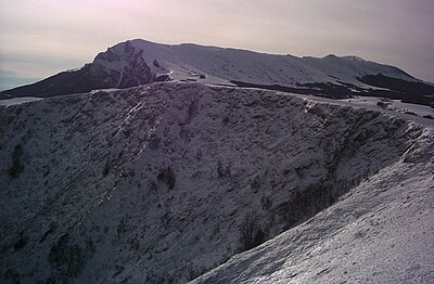
Chatyr-Dag (Crimean Tatar: Çatır Dağ, Ukrainian: Чатир-Даг, Russian: Чатыр-Даг) is a mountainous massif in Crimea, near the Simferopol-Alushta highway. In the Crimean Tatar language çatır means tent and dağ means mountain.
This article does not cite any sources. (June 2019) |
| Chatyr-Dag | |
|---|---|
| Crimean Tatar: Çatır Dağ | |
 | |
| Highest point | |
| Elevation | 1,527 m (5,010 ft) |
| Parent peak | Eklizi-Bourun |
| Coordinates | |
| Geography | |
| Location | Crimea |
| Parent range | Crimean Mountains |


Overview
The mountain consists of two plateaus: the lower (north) and the upper (south). The lower plateau slopes gently down to its northern side, which is covered in steppe grass. On its southern end (near the steep slope of the higher plateau), the lower plateau is covered with beech forests and juniper glades. It has many hiking trails and several beautiful caves (listed below). On the east side of the lower plateau there is a grove of yews.
The upper plateau has the shape of a giant bowl and on its rim; the highest peaks are each named. The upper plateau is covered with alpine meadows. Its slopes are very steep and offer some routes for multipitch climbing (rock climbing routes longer than length of one climbing rope). The highest peak is Eklizi-Bourun (1527 m above sea level).
Caves in the Chatyr-Dag massif include:
- Marble Caves
- Emine Bair Hosar cave
- Fur-tree cave
- Obvalnaya cave
- Vyalova cave
- Artuch-Koba
- Vyalova cave system


See also
- Mangup
- The Valley Of Ghosts
- Kara Dag Mountain
External links
На других языках
[de] Tschatyr-Dag
Tschatyr-Dag (krimtatarisch Çatır Dağ, ukrainisch Чатир-Даг, russisch Чатыр-Даг) ist ein Gebirgsmassiv auf der Halbinsel Krim. In der Sprache der Krimtataren bedeutet „çatır“ „Zelt“, „dağ“ steht für „Berg“.- [en] Chatyr-Dag
[fr] Tchatyr-Dah
Tchatyr-Dah (ukrainien : Чатир-Даг ; en russe : Чатыр-Даг, Tchatyr-Dag ; en tatar de Crimée : Çatır Dağ) est une montagne de Crimée. Elle se trouve près de la route Simferopol – Alouchta. En langue tatare de Crimée, çatır signifie « tente » et dağ signifie « montagne ».[ru] Чатыр-Даг
Чатыр-Да́г[2] (укр. Чатир-Даг, крымскотат. Çatır Dağ, Чатыр Дагъ) — горный массив (яйла), расположенный в южной части Крымского полуострова, в 10 км от моря, пятый по высоте в Крыму. Чатыр-Даг отождествляется с упоминаемой у Страбона горой Трапезунт (от др.-греч. Τραπεζοῦς ὄρος — «Стольная/столовая гора»)[3].Другой контент может иметь иную лицензию. Перед использованием материалов сайта WikiSort.org внимательно изучите правила лицензирования конкретных элементов наполнения сайта.
WikiSort.org - проект по пересортировке и дополнению контента Википедии
