geo.wikisort.org - Mountains
The Chaîne des Puys (French: [ʃɛn de pɥi]) is a north-south oriented chain of cinder cones, lava domes, and maars in the Massif Central of France.[1] The chain is about 40 km (25 mi) long, and the identified volcanic features, which constitute a volcanic field,[2] include 48 cinder cones, eight lava domes, and 15 maars and explosion craters.[3] Its highest point is the lava dome of Puy de Dôme, located near the middle of the chain, which is 1,465 m (4,806 ft) high.[3] The name of the range comes from a French term, puy, which refers to a volcanic mountain with a rounded profile. A date of 4040 BCE is usually given for the last eruption of a Chaîne des Puys volcano.[4]
| Chaîne des Puys | |
|---|---|
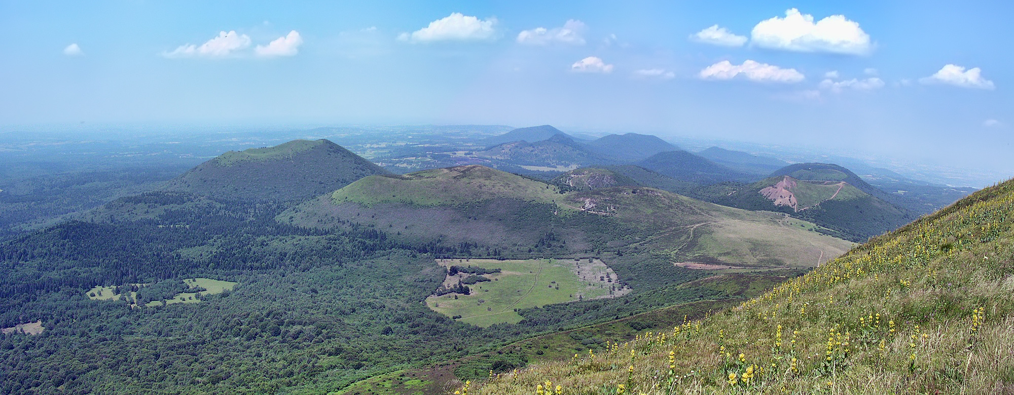 View of the Chaîne des Puys from Puy de Dôme | |
| Highest point | |
| Elevation | max. 1,464 m (4,803 ft) at Puy de Dôme |
| Coordinates | 45.5°N 2.8°E |
| Geography | |
 Chaîne des Puys Location of Chaîne des Puys | |
| Location | Auvergne-Rhône-Alpes, France |
| Parent range | Massif Central |
| Geology | |
| Age of rock | From 7,000 to 95,000 years |
| Mountain type | cinder cones, lava domes, and maars |
| Last eruption | 4040 BCE ± 150 years |
UNESCO World Heritage Site | |
| Official name | Chaîne des Puys - Limagne fault tectonic arena |
| Type | Natural |
| Criteria | (viii) |
| Designated | 2018 |
| Reference no. | 1434 |
| Region | Western Europe |
An outstanding example of plate tectonics in action and continental rifting, the Chaîne des Puys region became a UNESCO World Heritage Site in 2018.[5]
Formation
The Chaîne des Puys is located on the Limagne fault, a major part of the European Cenozoic Rift System which formed during the creation of the Alps roughly 35 million years ago.[5] The region has a wide variety of geologic features formed by the rifting. The mountain chain itself began to form approximately 95,000 years ago, and the volcanic activity that formed the range stopped about 10,000 years ago.[3] The majority of the cones were formed by Strombolian eruptions, and these cones usually have well-defined summit craters. Some have nested craters, and others show broken rims where lava poured through.[3]
In contrast, Puy de Dôme was created by a Peléan eruption; this type of eruption is characterized by long dormant periods periodically interrupted by sudden, extremely violent eruptions.[3]
Future eruptions at the Chaîne des Puys are possible and would result in the formation of new mountains.[6]
Research
Before 1750 and the chain's identification as volcanic, the Puys were rumored to be man-made mounds of mining waste or Roman forge furnaces.[7]
The chain was the subject of the pioneering research of English geologist George Julius Poulett Scrope, starting in the 1820s. In 1827 he published his Memoir on the Geology of Central France, including the Volcanic formations of Auvergne, the Velay and the Vivarais, which was later re-published in a revised and somewhat more popular form in The Geology and extinct Volcanos of Central France in 1858. These books were the first widely published descriptions of the Chaîne des Puys, and the analysis therein laid the foundation for many of the basic principles of volcanology.[citation needed]
References
- Johannes Baier: Das Vulkanfeld Chaîne des Puys. In: Aufschluss 72 (6), S. 310–321, 2021.
- Jouannic, G.; Walter-Simonnet, A.V.; Bossuet, G.; Cubizolle, H.; Boivin, P.; Devidal, J.-L.; Oberlin, C. (2014). "Occurrence of an unknown Atlantic eruption in the Chaîne des Puys volcanic field (Massif Central, France)". Journal of Volcanology and Geothermal Research. 283: 94–100. doi:10.1016/j.jvolgeores.2014.06.007.
- Scheffel, Richard L.; Wernet, Susan J., eds. (1980). Natural Wonders of the World. United States of America: Reader's Digest Association, Inc. pp. 306–307. ISBN 0-89577-087-3.
- "Chaine des Puys". Volcano World. Oregon State University. Retrieved 18 February 2016.
- "Chaîne des Puys - Limagne fault tectonic arena". UNESCO World Heritage Centre. United Nations Educational, Scientific, and Cultural Organization. Retrieved 16 Jan 2022.
- Bliss, Dominic (15 January 2020). "Chain Reaction: Exploring the Chaîne des Puys Volcanoes in France". France Today. Retrieved 2 May 2021.
- Cooper, Malcolm (2010). Volcano and Geothermal Tourism. p. 24. ISBN 9781136540899. Retrieved 4 May 2021.
Bibliography
- Scrope, George Poulett (1858). The Geology and extinct Volcanos of Central France. J. Murray, London. pp. 258. ISBN 0-405-10459-6. (reprinted in 1978 by Arno Press)
- Scarth, Alwyn; Tanguy, Jean-Claude (2001). Volcanoes of Europe. Oxford University Press. pp. 243 pp. ISBN 0-19-521754-3.
- Cattermole, Peter (2001). Auvergne (Classic Geology in Europe 2). Terra Publishing. pp. 176 pp. ISBN 1-903544-05-X.
- "Chaîne des Puys". Global Volcanism Program. Smithsonian Institution.
- Boivin Pierre; et al. (2004). Volcanologie de la Chaîne des Puys, Massif Central Français. Clermont-Ferrand: Parc Naturel Régional des Volcans d'Auvergne. OCLC 634970268.
World Heritage Sites in France | ||
|---|---|---|
| Île-de-France |
| |
| Parisian basin |
| |
| Nord-Pas-de-Calais |
| |
| East |
| |
| West |
| |
| South West |
| |
| Centre East |
| |
| Mediterranean |
| |
| Multiple regions |
| |
| Overseas departments and territories |
| |
| ||
| Authority control |
|
|---|
На других языках
[de] Chaîne des Puys
Die Chaîne des Puys, manchmal auch Monts Dômes genannt, ist eine Kette von vulkanischen Bergen, im französischen Zentralmassiv, in der Region Auvergne-Rhône-Alpes. Sie erstreckt sich in Nord-Süd-Richtung über eine Länge von etwa 30 Kilometern und umfasst an die hundert erloschene Vulkane. Sie liegt westlich von Clermont-Ferrand, im Département Puy-de-Dôme. Die höchste Erhebung ist der gleichnamige Puy de Dôme, mit einer Höhe von 1465 Metern über dem Meeresspiegel.- [en] Chaîne des Puys
[es] Cadena de los Puys
La cadena de los Puys (en francés, Chaîne des Puys), también llamada montes Dôme (monts Dôme), es un conjunto de aproximadamente 80 volcanes de Francia que se extienden a lo largo de 45 km en la meseta de los Dômes en el norte del Macizo Central, en Francia. Está situada al oeste de Clermont-Ferrand, en el departamento de Puy-de-Dôme en la región de Auvernia-Ródano-Alpes.[1][fr] Chaîne des Puys
La chaîne des Puys, aussi appelée monts Dôme, est un ensemble d'environ 80 volcans s'étirant sur plus de 45 km sur le plateau des Dômes dans le nord du Massif central, en France. Cet ensemble fait partie des volcans d'Auvergne, eux-mêmes faisant partie du parc naturel régional des Volcans d'Auvergne.[it] Chaîne des Puys
La chaîne des Puys[1], detta anche monts Dômes, è un complesso vulcanico che si estende per più di 30 chilometri, situato a ovest di Clermont-Ferrand, nel dipartimento del Puy-de-Dôme, in Alvernia-Rodano-Alpi, Francia. Si trova all'interno del Parco naturale regionale dei vulcani d'Alvernia.Другой контент может иметь иную лицензию. Перед использованием материалов сайта WikiSort.org внимательно изучите правила лицензирования конкретных элементов наполнения сайта.
WikiSort.org - проект по пересортировке и дополнению контента Википедии