geo.wikisort.org - Mountains
The Cerro de Chipinque is a mountain in the San Pedro Garza García, Monterrey and Santa Catarina municipalities; state of Nuevo León, Mexico. The mountain is part of the Sierra Madre Oriental range and the Cumbres de Monterrey National Park. The summit reaches 2,229 meters above sea level. The mountain is a symbol for the Monterrey metropolitan area.[1] The mountain is surrounded by Santa Catarina valley, San Pedro valley, mount El Mirador, la Silla river, Ballesteros Canyon and La Huasteca canyon. The “Parque ecológico Chipinque” is on the north slope of the mountain.[2] The mountain's name is believed to have originated from the nahualt word "chichipinqui" meaning small rain or from the name of an indigenous chief.[3]
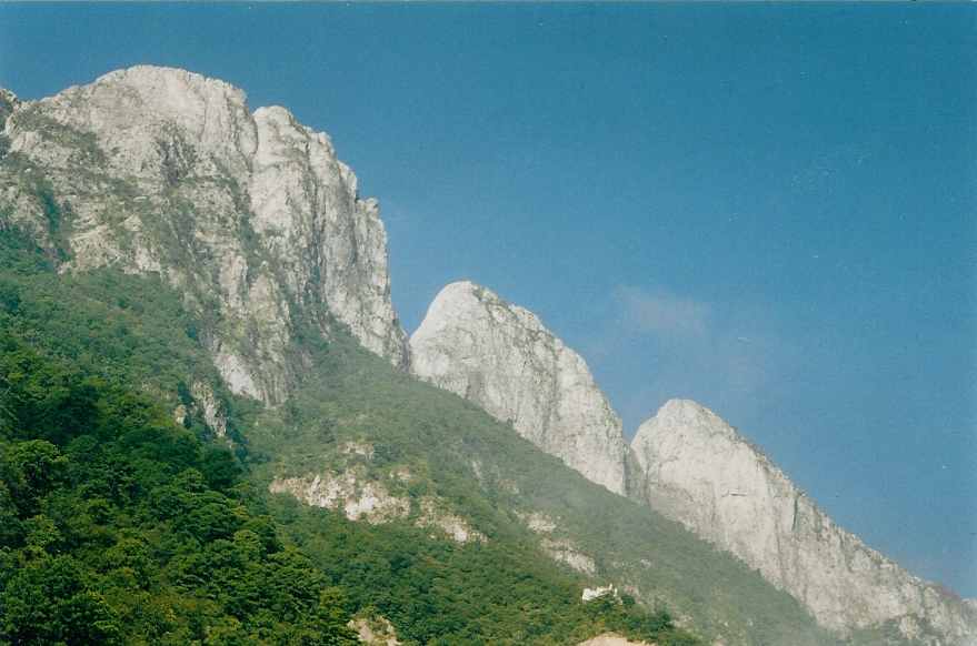
 La eme seen from the plateau of Chipinque Park.
 La eme seen from a hotel at the plateau.
 El Pinar seen from Chipinque


| Cerro de Chipinque | |
|---|---|
 Cerro de Chipinque seen from Monterrey | |
| Highest point | |
| Elevation | 2,229 m (7,313 ft) |
| Geography | |
 Cerro de Chipinque Location in Mexico | |
| Location | San Pedro, Monterrey, Santa Catarina; Nuevo León |
| Country | |
| Parent range | Sierra Madre Oriental |
| Geology | |
| Mountain type | Mountain |
History
Though this area's beauty was widely known, it wasn't an Ecological Park until 1992, when a board of trustees made up of the government of the State of Nuevo León and a private initiative was formalized. It was also known as an obligatory destination for most biology and ecology enthusiasts, as the typical northern habitat and biodiversity made it unique.[4]
The mission of this park is to maintain biodiversity in the area, by means of controlling the use of natural resources responsibly. Chipinque is open every day of the year, from 6am to 8pm local time. Most of the park is open to all people, though authorization and a guide are needed to climb some of the higher peaks. The park's staff consists of 22 forest rangers.[4]
Geography
Cerro de Chipinque is in the Sierra Madre Oriental, within the bounds of Cumbres de Monterrey National Park. It has a land area of 1625 hectares though only about 300 of these are open to the general public. With altitudes ranging from 800m to around 2200m above sea level, the tallest peak is known as Copete de las Aguillas, which is Spanish for crest of the eagles. The main crest is about 17 km long.
Biology and ecology

Flora
This area is defined mainly by the large coniferous forest. Some of the plants there are Garrya, Huizche otherwise known as Sweet Acacia, American Agave, Encino Duraznillo and Oak.[5]
Fauna
This area's fauna consists mainly of large mammals and birds. Some of the mammals are Coyotes, Wildcats, Coatis, White tail deer and the grey wolf. Some of the birds are Red-tailed Hawk, Turkey vulture, Wild Turkey, Mountain pygmy owl, Bronzed cowbird and the Blue-capped motmot. Some of the reptiles are spiny lizards, Texas alligator lizards, and Blacktail cribos.[6] The park stands out for its multitude of butterfly species.
Climate
The average temperature of Chipinque is 20 °C, with an average yearly rain being 860mm. This area is mainly a subhumid temperate forest and submontane scrubland. The forests are mainly pines and oak.[4]
References
- "Nuevo León-San Pedro Garza García".
- "Planea tu visita – Parque Ecológico Chipinque" (in Mexican Spanish). Retrieved 2019-05-02.
- Aguilar, Antonio Guerrero (2014-05-19). "Identidad y memoria de Santa Catarina, Nuevo León: Chipinque, Nuevo León". Identidad y memoria de Santa Catarina, Nuevo León. Archived from the original on 30 April 2019. Retrieved 2022-06-01.
- "Parque ecológico Chipinque: una alternativa en Nuevo León". México Desconocido (in Spanish). 2010-08-25. Retrieved 2022-06-01.
- "Flora – Parque Ecológico Chipinque" (in Mexican Spanish). Retrieved 2022-06-01.
- "Fauna – Parque Ecológico Chipinque" (in Mexican Spanish). Retrieved 2022-06-01.
На других языках
- [en] Cerro de Chipinque
[es] Cerro de Chipinque
El Cerro de Chipinque es una montaña en los municipios de San Pedro Garza García, Monterrey y Santa Catarina del estado de Nuevo León, México. La montaña forma parte de la Sierra Madre Oriental y del parque nacional Cumbres de Monterrey. La cima está a 2,230 metros sobre el nivel del mar. La montaña es uno de los símbolos de la Zona Metropolitana de Monterrey, y la formación rocosa “La eme” está representada en el escudo municipal de San Pedro Garza García.[1] El Cerro de Chipinque está rodeado por el Valle de Santa Catarina, el Valle de San Pedro, el Cerro del Mirador, el Río la Silla, el Cañón de Ballesteros y el Cañón de La Huasteca. En la ladera norte, en San Pedro Garza García, se encuentra el Parque Ecológico Chipinque.[2]Другой контент может иметь иную лицензию. Перед использованием материалов сайта WikiSort.org внимательно изучите правила лицензирования конкретных элементов наполнения сайта.
WikiSort.org - проект по пересортировке и дополнению контента Википедии