geo.wikisort.org - Mountains
Bodmin Moor (Cornish: Goon Brenn)[1] is a granite moorland in north-eastern Cornwall, England. It is 208 square kilometres (80 sq mi) in size, and dates from the Carboniferous period of geological history. It includes Brown Willy, the highest point in Cornwall, and Rough Tor, a slightly lower peak. Many of Cornwall's rivers have their sources here. It has been inhabited since at least the Neolithic era, when primitive farmers started clearing trees and farming the land. They left their megalithic monuments, hut circles and cairns, and the Bronze Age culture that followed left further cairns, and more stone circles and stone rows. By medieval and modern times, nearly all the forest was gone and livestock rearing predominated.

The name Bodmin Moor is relatively recent. An early mention is in the Royal Cornwall Gazette of 28 November 1812.[2] The upland area was formerly known as Fowey Moor after the River Fowey, which rises within it.[3]
Geology
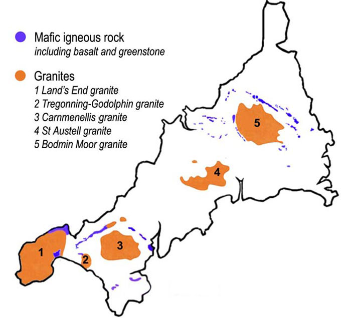
Bodmin Moor is one of five granite plutons in Cornwall that make up part of the Cornubian batholith.[4] The intrusion dates from the Cisuralian epoch, the earliest part of the Permian period, and outcrops across about 190 square km. Around the pluton's margins where it intruded into slates, the country rock has been hornfelsed. Numerous peat deposits occur across the moor whilst large areas are characterised by blockfields of granite boulders; both deposits are of Holocene age[5] (see also Geology of Cornwall).
Geography
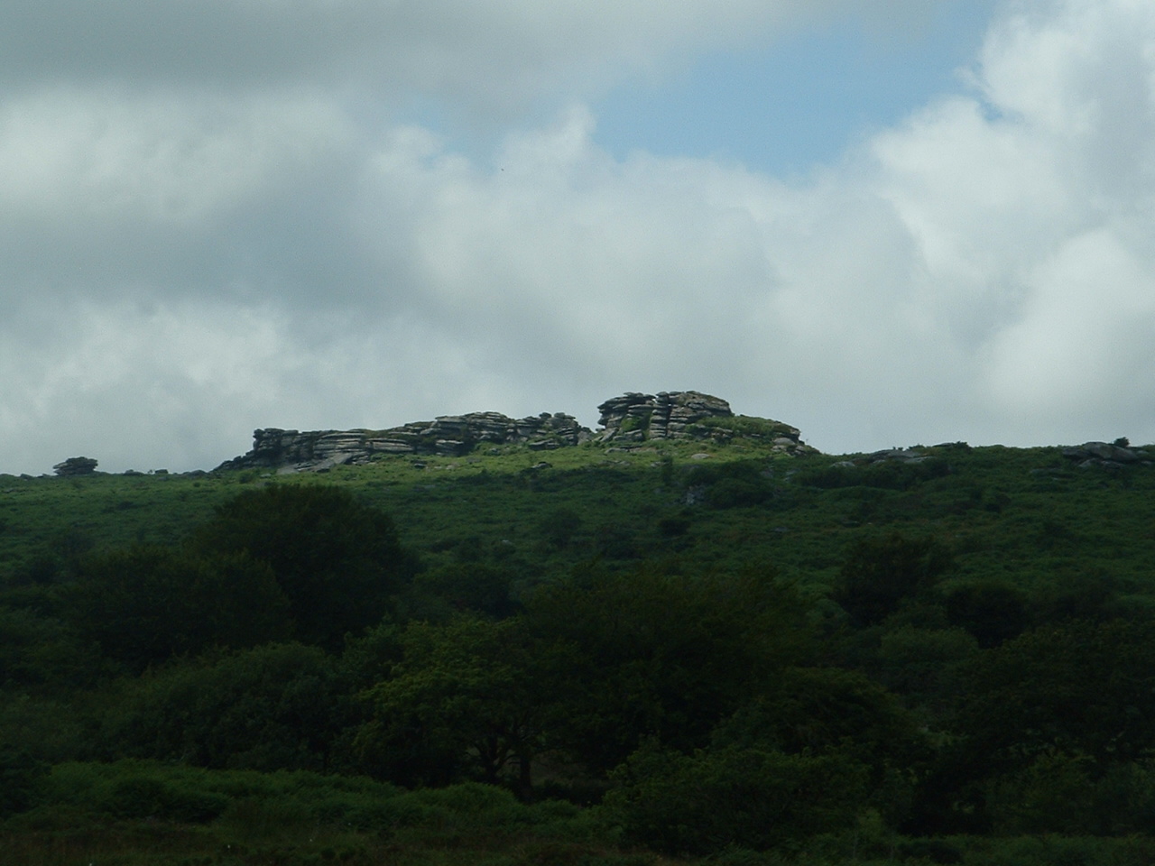
Dramatic granite tors rise from the rolling moorland: the best known are Brown Willy, the highest point in Cornwall at 417 m (1,368 ft),[6] and Rough Tor at 400 m (1,300 ft). To the south-east Kilmar Tor and Caradon Hill are the most prominent hills.[7] Considerable areas of the moor are poorly drained and form marshes (in hot summers these can dry out). The rest of the moor is mostly rough pasture or covered with heather and other low vegetation.[8]
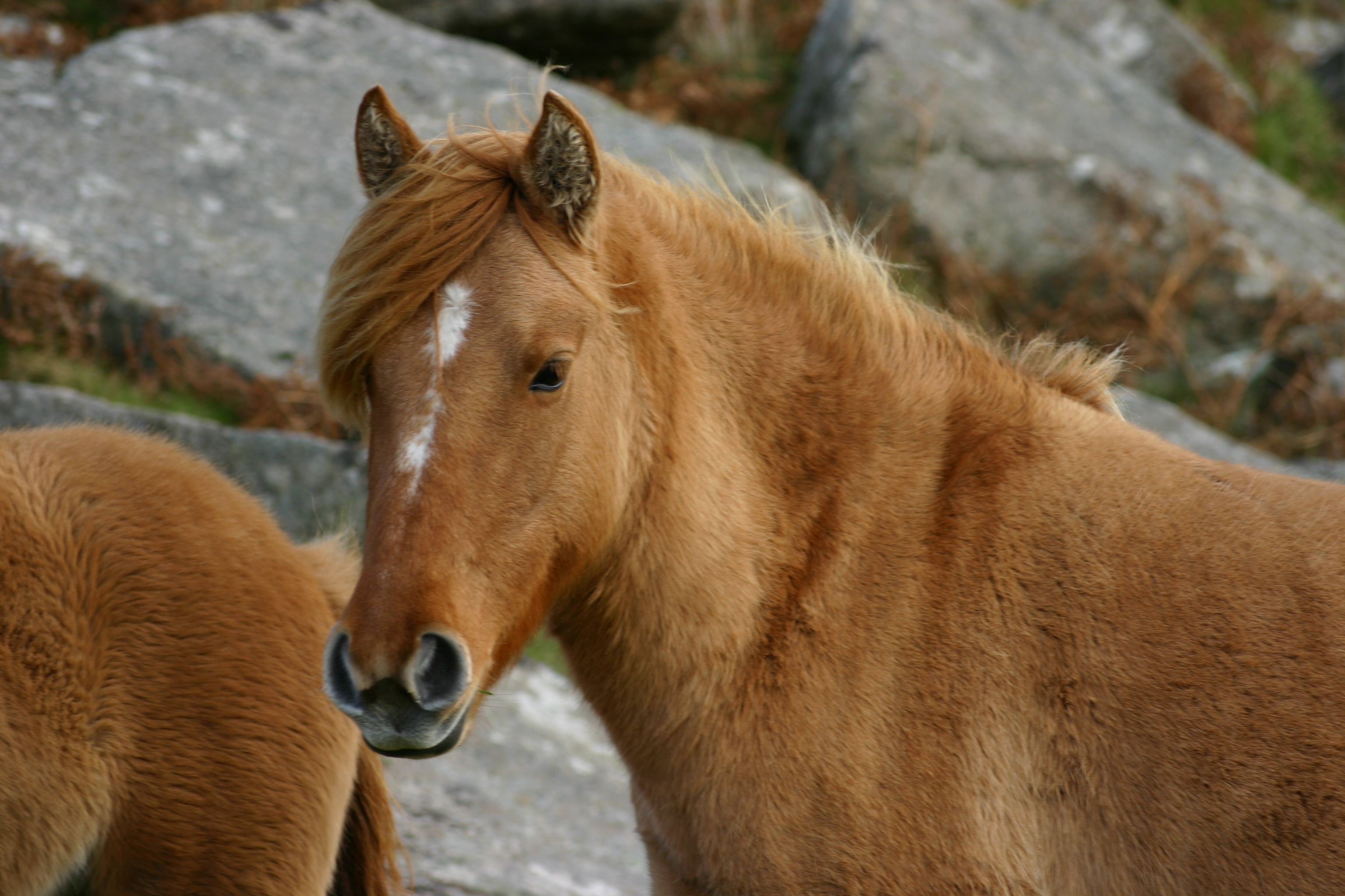
The moor contains about 500 holdings with around 10,000 beef cows, 55,000 breeding ewes and 1,000 horses and ponies.[9] Most of the moor is a Site of Special Scientific Interest (SSSI), Bodmin Moor, North,[10] and has been designated an Area of Outstanding Natural Beauty (AONB), as part of Cornwall AONB.[11] The moor has been identified by BirdLife International as an Important Bird Area (IBA) because it supports about 260 breeding pairs of European stonechats as well as a wintering population of 10,000 Eurasian golden plovers.[12] The moor has also been recognised as a separate natural region and designated as national character area 153 by Natural England.[13]
Rivers and inland waters


Bodmin Moor is the source of several of Cornwall's rivers: they are mentioned here anti-clockwise from the south.
The River Fowey rises at a height of 290 m (950 ft) and flows through Lostwithiel and into the Fowey estuary.[14]
The River Tiddy rises near Pensilva and flows southeast to its confluence with the River Lynher (the Lynher flows generally south-east until it joins the Hamoaze near Plymouth). The River Inny rises near Davidstow and flows southeast to its confluence with the River Tamar.[15]
The River Camel rises on Hendraburnick Down and flows for approximately 40 km (25 mi) before joining the sea at Padstow.[16] The River Camel and its tributary the De Lank River are an important habitat for the otter, and both have been proposed as Special Areas of Conservation (SAC)[17] The De Lank River rises near Roughtor and flows along an irregular course before joining the Camel south of Wenford.[15]
The River Warleggan rises near Temple and flows south to join the Fowey.[7]
On the southern slopes of the moor lies Dozmary Pool. It is Cornwall's only natural inland lake and is glacial in origin. In the 20th century three reservoirs have been constructed on the moor; these are Colliford Lake, Siblyback Lake and Crowdy reservoirs, which supply water for a large part of the county's population. Various species of waterfowl are resident around these rivers.[18]
 Rivers south of Bodmin Moor
 Rivers southeast of Bodmin moor
 Rivers northwest of Bodmin Moor


Parishes
The parishes on the moor are as follows:
|
History and antiquities
Prehistoric times


10,000 years ago, in the Mesolithic period, hunter-gatherers wandered the area when it was wooded. There are several documented cases of flint scatters being discovered by archaeologists, indicating that these hunter-gatherers practised flint knapping in the region.[19]
During the Neolithic era, from about 4,500 to 2,300 BC, people began clearing trees and farming the land. It was also in this era that the production of various megalithic monuments began, predominantly long cairns (three of which have currently been identified, at Louden, Catshole and Bearah) and stone circles (sixteen of which have been identified). It was also likely that the naturally forming tors were also viewed in a similar manner to the manmade ceremonial sites.[19]
In the following Bronze Age, the creation of monuments increased dramatically, with the production of over 300 further cairns, and more stone circles and stone rows.[19] More than 200 Bronze Age settlements with enclosures and field patterns have been recorded.[20] and many prehistoric stone barrows and circles lie scattered across the moor. In the late 1990s, a team of archaeologists and anthropologists from UCL researched the Bronze Age landscapes of Leskernick over several seasons (Barbara Bender; Sue Hamilton; Christopher Tilley and students).[21][22] In a programme shown in 2007 Channel 4's Time Team investigated a 500-metre cairn and the site of a Bronze Age village on the slopes of Rough Tor.[23]
King Arthur's Hall, thought to be a late Neolithic or early Bronze Age ceremonial site, can be found to the east of St Breward on the moor.[24]
Medieval and modern times
Where practicable, areas of the moor were used for pasture by herdsmen from the parishes surrounding the moor. Granite boulders were also taken from the moor and used for stone posts and to a certain extent for building (such material is known as moorstone).[25] Granite quarrying only became reasonably productive when gunpowder became available.
The moor gave its name (Foweymore) to one of the medieval districts called stannaries which administered tin mining: the boundaries of these were never defined precisely. Until the establishment of a turnpike road through the moor (the present A30) in the 1770s the size of the moorland area made travel within Cornwall very difficult.[26]
Its Cornish name, Goen Bren, is first recorded in the 12th century.[27]
English Heritage monographs "Bodmin Moor: An Archaeological Survey" Volume 1 and Volume 2 covering the post-medieval and modern landscape are publicly available through the Archaeology Data Service.[28][29]
Jamaica Inn is a traditional inn on the Moor. Built as a coaching inn in 1750 and having an association with smuggling, it was used as a staging post for changing horses.
In the 1980s, there was a big problem with the water supply in Camelford. Many people had medical issues after this and some died.[30]
Monuments and ruins
Roughtor was the site of a medieval chapel of St Michael and is now designated as a memorial to the 43rd Wessex Division of the British Army. In 1844 on Bodmin Moor the body of 18-year-old Charlotte Dymond was discovered. Local labourer Matthew Weeks was accused of the murder, and at noon on 12 August 1844 he was led from Bodmin Gaol and hanged. The murder site now has a monument erected from public money, and her grave is at Davidstow churchyard.[31]
Legends and traditions
Dozmary Pool is identified by some people with the lake in which, according to Arthurian legend, Sir Bedivere threw Excalibur to The Lady of the Lake.[32] Another legend relating to the pool concerns Jan Tregeagle.
The Beast of Bodmin has been reported many times but never identified with certainty.[33]
Film
Cornish Cowboy, a 2014 short documentary film screened at the 2015 Cannes Film Festival,[34] was shot on Bodmin Moor.[35] The film features the work of St Neot horse trainer, Dan Wilson.
See also
- List of topics related to Cornwall
- Brown Willy effect
- Jamaica Inn (novel)
References

- Place-names in the Standard Written Form (SWF) Archived 15 May 2013 at the Wayback Machine : List of place-names agreed by the MAGA Signage Panel Archived 15 May 2013 at the Wayback Machine. Cornish Language Partnership.
- "To Mr. Flindell". Royal Cornwall Gazette. England. 28 November 1812. Retrieved 17 May 2018 – via British Newspaper Archive.
- Pounds, Norman John Greville (2000). A History of the English Parish: the culture of religion from Augustine to Victoria. Cambridge University Press. p. 593. ISBN 978-0-521-63351-2.; p. 72
- Charoy, B (1986). "Genesis of the Cornubian Batholith (South West England): the example of the Carnmenellis Pluton". Journal of Petrology; Oxford: OUP. Archived from the original on 13 July 2012. Retrieved 27 November 2014.
- "Geoindex Onshore". British Geological Survey. Retrieved 20 June 2020.
- "GENUKI: Cornwall". Genuki.org.uk. Retrieved 27 November 2014.
- "Bodmin and Launceston". Sheet 186, One-inch map of England and Wales. Ordnance Survey.
{{cite web}}: Missing or empty|url=(help) - "Bodmin Moor: Landscape and features". South Penquite Farm. Retrieved 13 August 2016.
- "The Bodmin Moor Pages ~ The History". Bodminmoor.co.uk. Retrieved 27 November 2014.
- "Bodmin Moor, North" (PDF). Natural England. 1991. Archived from the original (PDF) on 24 October 2012. Retrieved 26 October 2011.
- Archived 27 January 2013 at the Wayback Machine
- "Bodmin Moor". Important Bird Areas factsheet. BirdLife International. 2013. Archived from the original on 30 June 2007. Retrieved 19 April 2013.
- "NCA Profile:153 Bodmin Moor - NE415". naturalengland.org.uk. 7 October 2014. Retrieved 15 January 2022.
- "Cornwall Rivers Project - Geography - Fowey and Lerryn". Cornwallriversporject/org.uk. Retrieved 27 November 2014.
- "The Rivers of Bodmin Moor". South Penquite Farm. Retrieved 13 August 2016.
- "Cornwall Rivers Project - Geography - Camel and Allen". Cornwallriversproject.org.uk. Retrieved 27 November 2014.
- "The Rivers of Bodmin Moor - The Bodmin Moor Pages". Bodminmoore.co.uk. Retrieved 27 November 2014.
- Bere, Rennie (1982) The Nature of Cornwall. Buckingham: Barracuda Books, pp. 63–67
- Tilley, C. (1996). World Archaeology: The Power of Rocks: landscape and topography on Bodmin Moor. pp. 151–176.
- "Programmes - All - Channel 4". Channel 4. Retrieved 27 November 2014.
- Hamilton, Sue; Tilley, Christopher; Bender, Barbara (22 November 1999). "Bronze Age stone worlds of Bodmin Moor: excavating Leskernick". Archaeology International. 3. doi:10.5334/ai.v3i0.174. ISSN 2048-4194.
- Bender, Barbara; Hamilton, Sue; Tilley, Christopher (1997). "Leskernick: Stone Worlds; Alternative Narratives; Nested Landscapes". Proceedings of the Prehistoric Society. 63: 147–178. doi:10.1017/s0079497x00002413. ISSN 0079-497X. S2CID 128438440.
- "Bodmin Moor, Cornwall". Channel 4: Time Team. 8 April 2007. Retrieved 9 November 2009.
- "Secret cornwall - Bodmin moor and its environs". Whitedragon.org.uk. Archived from the original on 25 April 2015. Retrieved 27 November 2014.
- Clifton-Taylor, A. "Building materials" in: Pevsner, N. (1970) Cornwall. 2nd ed. Penguin Books, pp. 29–34
- "County: [Cornwall]. Description of Courts: Manorial Courts. Places: Foweymore (Foymore)..." heNational Archives. Retrieved 13 August 2016.
- Weatherhill, Craig (2009) A Concise Dictionary of Cornish Place-names. Westport, co. Mayo: Evertype; p. 6
- Bonney, D., Johnson, N., Rose, P. (2008) "Bodmin Moor An archaeological survey Volume 1: The human Landscape c.1800" English Heritage.
- Giles, C., Herring, P., Johnson, N., Sharpe, A., Smith, J. (2008) "Bodmin Moor An Archaeological survey Volume 2: The industrial and post-medieval landscapes" English Heritage.
- "Camelford Water Pollution Case".
- "The Murder of Charlotte Dymond". Parmaq.com. Archived from the original on 4 December 2014. Retrieved 27 November 2014.
- Cornish Archaeology; No 34, 1995
- "The Beast of Bodmin Moor". Natural History Museum. Archived from the original on 7 April 2015. Retrieved 23 April 2014.
- "CORNISH COWBOY". sub.festival-cannes.fr. Archived from the original on 20 December 2016. Retrieved 16 February 2016.
- "Bodmin Moor horse whisperer featured in movie".[permanent dead link]
- Weatherhill, Craig (1995) Cornish Place Names & Language. Wilmslow: Sigma Leisure ISBN 1-85058-462-1
External links
Cornwall Portal | |
| Unitary authorities |
|
| Major settlements |
|
| Rivers | |
| Topics |
|
Authority control | |
|---|---|
| General |
|
| National libraries | |
Другой контент может иметь иную лицензию. Перед использованием материалов сайта WikiSort.org внимательно изучите правила лицензирования конкретных элементов наполнения сайта.
WikiSort.org - проект по пересортировке и дополнению контента Википедии