geo.wikisort.org - Mountains
The Blue Mountains are the longest mountain range in Jamaica. They include the island's highest point, Blue Mountain Peak, at 2256 m (7402 ft).[1] From the summit, accessible via a walking track, both the north and south coasts of the island can be seen. On a clear day, the outline of the island of Cuba, 210 km (130 mi) away, can also be seen. The mountain range spans four parishes: Portland, St. Thomas, St. Mary and St. Andrew.
| Blue Mountains | |
|---|---|
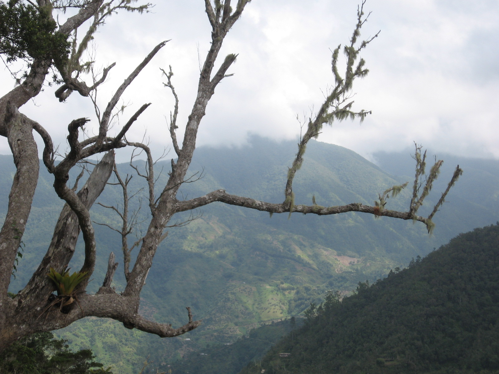 View of the Blue Mountain Range looking into St. Mary Parish from St.Andrew Parish. | |
| Highest point | |
| Peak | Blue Mountain Peak |
| Elevation | 2,256 m (7,402 ft) |
| Coordinates | 818°6′N 76°40′W |
| Geography | |
| Country | Jamaica |
UNESCO World Heritage Site | |
| Official name | Blue and John Crow Mountains |
| Type | Mixed |
| Criteria | iii, vi, x |
| Designated | 2015 (39th session) |
| Reference no. | 1356 |
| Region | Americas |
Geography
The Blue Mountains dominate the eastern third of Jamaica, while bordering the eastern parishes of Portland, St. Thomas, St. Mary and St. Andrew to the south. Part of the Blue Mountains is contained in the Blue and John Crow Mountains National Park established in 1992, which is maintained by the Jamaican government.
The Blue Mountains rise to its elevations from the coastal plain in the space of about 16 kilometres (9.9 mi), thus producing one of the steepest general gradients in the world. This forms cooling relief from the sweltering heat of the city of Kingston, visible below. Their summits rise and fall for 38.62 kilometres (24.00 mi) and span 22.53 kilometres (14.00 mi) at their widest point. The temperature decreases from around 27 °C (80 °F) at sea level to 5 °C (40 °F) at the Blue Mountain Peak, just 16 km (9.9 mi) inland.
Rainfall
The island's average rainfall is 1,960 millimetres (77 in) per year.[citation needed] Where the higher elevations of the Blue Mountains catch the rain from moisture-laden winds it exceeds 5,080 millimetres (200 in) per year[citation needed] with some areas recording totals of more than 7,620 millimetres (300 in).[citation needed]
Climate data
| Climate data for Blue Mountains (altitude: 1,493 metres (4,898 ft)) | |||||||||||||
|---|---|---|---|---|---|---|---|---|---|---|---|---|---|
| Month | Jan | Feb | Mar | Apr | May | Jun | Jul | Aug | Sep | Oct | Nov | Dec | Year |
| Average high °C (°F) | 20.0 (68.0) |
19.9 (67.8) |
21.0 (69.8) |
21.5 (70.7) |
21.8 (71.2) |
22.9 (73.2) |
23.7 (74.7) |
23.7 (74.7) |
23.0 (73.4) |
21.9 (71.4) |
21.1 (70.0) |
20.4 (68.7) |
21.7 (71.1) |
| Average low °C (°F) | 11.9 (53.4) |
11.7 (53.1) |
12.0 (53.6) |
12.6 (54.7) |
13.5 (56.3) |
14.2 (57.6) |
14.7 (58.5) |
15.0 (59.0) |
14.4 (57.9) |
14.5 (58.1) |
14.0 (57.2) |
12.9 (55.2) |
13.5 (56.3) |
| Average precipitation mm (inches) | 126 (5.0) |
116 (4.6) |
103 (4.1) |
172 (6.8) |
219 (8.6) |
141 (5.6) |
79 (3.1) |
179 (7.0) |
226 (8.9) |
343 (13.5) |
396 (15.6) |
235 (9.3) |
2,335 (91.9) |
| Average precipitation days | 12 | 9 | 9 | 11 | 14 | 9 | 7 | 10 | 14 | 17 | 16 | 14 | 142 |
| Average relative humidity (%) (at 13:00) | 83 | 84 | 84 | 85 | 86 | 83 | 80 | 83 | 87 | 90 | 88 | 87 | 85 |
| Mean monthly sunshine hours | 127.1 | 87.6 | 145.7 | 132.0 | 124.0 | 138.0 | 155.0 | 145.7 | 129.0 | 127.1 | 126.0 | 124.0 | 1,561.2 |
| Mean daily sunshine hours | 4.1 | 3.1 | 4.7 | 4.4 | 4.0 | 4.6 | 5.0 | 4.7 | 4.3 | 4.1 | 4.2 | 4.0 | 4.3 |
| Source: Meteorological Service (Jamaica)[2] | |||||||||||||
Flora and fauna
The Blue Mountains climatic diversity has led to the growth of diverse and lush vegetation including towering trees and more than 500 species of flowering plants.[citation needed]
The mountains are home to the world's second-largest butterfly and the largest in the Americas, the Homerus swallowtail.[3] This is the most well-studied remaining population of the endangered butterfly.[3] The Jamaican Coney (Geocapromys brownii), a type of rodent,[citation needed] and the Jamaican boa (Chilabothrus subflavus) are also found there.[citation needed]
Jamaican coffee
In past years when Jamaica's economy was dominated by plantation slavery, some slaves escaped to the mountains to live independently, where they were known as Jamaican Maroons. Charles Town, Jamaica on the Buff Bay River in central Portland, Moore Town in eastern Portland, and Scott's Hall, Jamaica in St Mary are the contemporary communities of Windward Maroons.
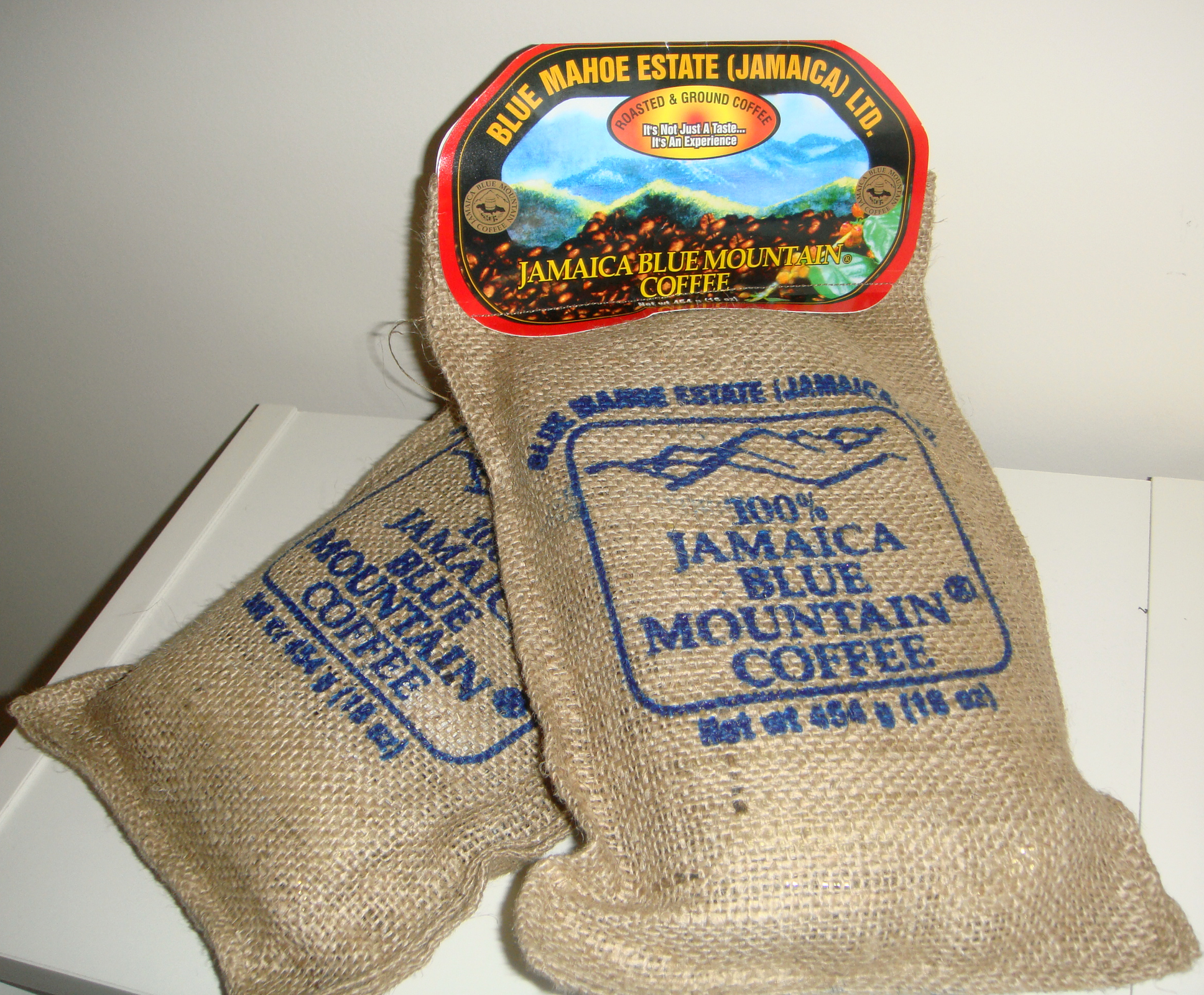
Today, the famous Jamaican Blue Mountain Coffee, which commands premium prices on world markets, is cultivated between 0.6 kilometres (0.37 mi) and 1.5 kilometres (0.93 mi) above sea level,[4] while higher slopes are preserved as forest. Hagley Gap and Mavis Bank are farming communities located on Blue Mountain with Hagley Gap being closest to Blue Mountain Peak. Both towns rely upon the area's rich soil for growing coffee.
References
- Hamilton, Janice (2005), Jamaica in Pictures, Lerner Publications, p. 10, ISBN 0-8225-2394-9
- "Mean Climatological Data" (PDF). Meteorological Service (Jamaica). Archived from the original (PDF) on 16 September 2012. Retrieved 7 September 2016.
- Lehnert, Matthew S.; Kramer, Valerie R.; Rawlins, John E.; Verdecia, Vanessa; Daniels, Jaret C. (2017-07-10). "Jamaica's Critically Endangered Butterfly: A Review of the Biology and Conservation Status of the Homerus Swallowtail (Papilio (Pterourus) homerus Fabricius)". Insects. 8 (3): 68. doi:10.3390/insects8030068. PMC 5620688. PMID 28698508.
- Rebecca Tortello. "Jamaican Coffee - "A Beverage of Distinction"". A Jamaica Gleaner Feature. Archived from the original on 28 January 2011. Retrieved 19 March 2011.
External links
Geography of Jamaica | |||||||||||||||||||||||
|---|---|---|---|---|---|---|---|---|---|---|---|---|---|---|---|---|---|---|---|---|---|---|---|
| Subdivisions |
| ||||||||||||||||||||||
| Settlements |
| ||||||||||||||||||||||
| Landforms |
| ||||||||||||||||||||||
| Extreme points |
| ||||||||||||||||||||||
| Natural disasters |
| ||||||||||||||||||||||
| Fauna |
| ||||||||||||||||||||||
| Flora | Flora of Jamaica | ||||||||||||||||||||||
| Maps |
| ||||||||||||||||||||||
На других языках
- [en] Blue Mountains (Jamaica)
[fr] Blue Mountains (Jamaïque)
Les Blue Mountains est le nom donné à un massif montagneux qui occupe le tiers oriental de l'île de la Jamaïque.[it] Blue Mountains (Giamaica)
Le Blue Mountains sono la catena montuosa più lunga della Giamaica. Il punto più elevato è il Blue Mountain Peak, a 2256 m. Dalla cima si possono vedere la costa nord e sud dell'isola, inoltre nelle giornate limpide si può scorgere la sagoma di Cuba, a 210 chilometri di distanza.[ru] Блу-Маунтинс (Ямайка)
Блу-Ма́унтинс[1] (англ. Blue Mountains) — горы на востоке Ямайки. Самая высокая точка — гора Блу-Маунтин-Пик (2256 м). Часть гор Блу-Маунтинс входит в основанный в 1992 году национальный парк.Другой контент может иметь иную лицензию. Перед использованием материалов сайта WikiSort.org внимательно изучите правила лицензирования конкретных элементов наполнения сайта.
WikiSort.org - проект по пересортировке и дополнению контента Википедии