geo.wikisort.org - Île
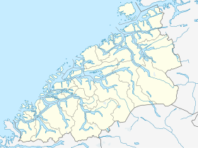
Remøya est une île de l'archipel de Sørøyane appartenant à la commune de Herøy, du comté de Møre og Romsdal, dans la mer de Norvège[1].
Cet article est une ébauche concernant le monde insulaire et la Norvège.
Vous pouvez partager vos connaissances en l’améliorant (comment ?) selon les recommandations des projets correspondants.
| Remøya | |||

| |||
| Géographie | |||
|---|---|---|---|
| Pays | |||
| Archipel | Sørøyane | ||
| Localisation | Mer de Norvège | ||
| Coordonnées | 62° 22′ 10″ N, 5° 38′ 21″ E | ||
| Superficie | 3,6 km2 | ||
| Point culminant | Vardan (191 m) | ||
| Administration | |||
| Région | Vestlandet | ||
| Comté | Møre og Romsdal | ||
| Municipalité | Herøy | ||
| Démographie | |||
| Population | 330 hab. (2015) | ||
| Densité | 91,67 hab./km2 | ||
| Autres informations | |||
| Fuseau horaire | UTC+02:00 | ||
| Géolocalisation sur la carte : Møre og Romsdal
Géolocalisation sur la carte : Norvège
| |||
| Île en Norvège | |||
| modifier |
|||

Description
L'île de 3,6 km2 est située au nord du centre municipal de Fosnavåg sur l'île voisine de Bergsøya. L'île est reliée à d'autres îles via un réseau de ponts. Le Remøy Bridge (en) la relie à l'île Leinøya (au sud) et le Runde Bridge (en) la relie à Runde (au nord).
Pratiquement tous les habitants de l'île vivent dans la partie sud de l'île dans la zone villageoise de 0,41 kilomètre carré (100 acres) appelée Remøy[2].
Galerie
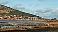 Pont de Remøy
 Le Pont de Runde


Voir aussi
Notes et références
Liens internes
 Portail de la Norvège
  Portail du monde insulaire
На других языках
[de] Remøya
Remøya (inoffiziell auch Rimøya[1]) ist eine zu den Sørøyane („Südinseln“) gehörende Insel in der norwegischen Region Sunnmøre, in der Provinz (Fylke) Møre og Romsdal.[en] Remøya
Remøya is an island in the municipality of Herøy in Møre og Romsdal county, Norway. The island is located north of the municipal center of Fosnavåg. The 3.6-square-kilometre (1.4 sq mi) island is connected to other islands via a network of bridges. The Remøy Bridge connects it to the island Leinøya (to the south) and the Runde Bridge connects it to Runde (to the north). The highest point on the island is Vardan which is 191 metres (627 ft) above sea level. Virtually all of the island's residents live on the southern portion of the island in the 0.41-square-kilometre (100-acre) village area called Remøy. The island had a population of 330 in 2015.[1]- [fr] Remøya
Текст в блоке "Читать" взят с сайта "Википедия" и доступен по лицензии Creative Commons Attribution-ShareAlike; в отдельных случаях могут действовать дополнительные условия.
Другой контент может иметь иную лицензию. Перед использованием материалов сайта WikiSort.org внимательно изучите правила лицензирования конкретных элементов наполнения сайта.
Другой контент может иметь иную лицензию. Перед использованием материалов сайта WikiSort.org внимательно изучите правила лицензирования конкретных элементов наполнения сайта.
2019-2026
WikiSort.org - проект по пересортировке и дополнению контента Википедии
WikiSort.org - проект по пересортировке и дополнению контента Википедии