geo.wikisort.org - Island
Remøya is an island in the municipality of Herøy in Møre og Romsdal county, Norway. The island is located north of the municipal center of Fosnavåg. The 3.6-square-kilometre (1.4 sq mi) island is connected to other islands via a network of bridges. The Remøy Bridge connects it to the island Leinøya (to the south) and the Runde Bridge connects it to Runde (to the north). The highest point on the island is Vardan which is 191 metres (627 ft) above sea level. Virtually all of the island's residents live on the southern portion of the island in the 0.41-square-kilometre (100-acre) village area called Remøy. The island had a population of 330 in 2015.[1]
 View of the island | |
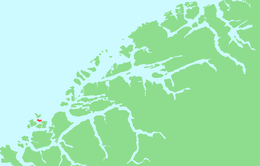 | |
 Remøya Location of the island  Remøya Remøya (Norway) | |
| Geography | |
|---|---|
| Location | Møre og Romsdal, Norway |
| Coordinates | 62.3683°N 5.6397°E |
| Area | 3.6 km2 (1.4 sq mi) |
| Highest elevation | 191 m (627 ft) |
| Highest point | Vardan |
| Administration | |
Norway | |
| County | Møre og Romsdal |
| Municipality | Herøy Municipality |
| Demographics | |
| Population | 330 (2015) |
See also
References
- Thorsnæs, Geir, ed. (2015-09-12). "Remøya". Store norske leksikon (in Norwegian). Kunnskapsforlaget. Retrieved 2019-09-08.
This Møre og Romsdal location article is a stub. You can help Wikipedia by expanding it. |
На других языках
[de] Remøya
Remøya (inoffiziell auch Rimøya[1]) ist eine zu den Sørøyane („Südinseln“) gehörende Insel in der norwegischen Region Sunnmøre, in der Provinz (Fylke) Møre og Romsdal.- [en] Remøya
Другой контент может иметь иную лицензию. Перед использованием материалов сайта WikiSort.org внимательно изучите правила лицензирования конкретных элементов наполнения сайта.
WikiSort.org - проект по пересортировке и дополнению контента Википедии