geo.wikisort.org - Island
The Whidbey Isles Conservation Park is a protected area in the Australian state of South Australia which consists of seven islands located about 15 kilometres (9.3 mi) west-southwest of Coffin Bay on the lower Eyre Peninsula.[4]
| Whidbey Isles Conservation Park South Australia | |
|---|---|
IUCN category Ia (strict nature reserve)[1] | |
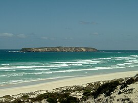
 Golden Island seen from Almonta Beach | |
 Whidbey Isles Conservation Park | |
| Nearest town or city | Coffin Bay. |
| Coordinates | 34°43′37.6″S 135°09′33″E |
| Established | 16 March 1967[2] |
| Area | 2.48 km2 (1.0 sq mi)[3] |
| Managing authorities | Department for Environment and Water |
| See also | Protected areas of South Australia |
The conservation park consists of all of the islands in Whidbey Isles, i.e. the Four Hummocks group, Perforated Island, Price Island and Golden Island, with the exception of the most southerly island in the Four Hummocks which is the subject of a lighthouse reserve under the control of the Australian government.[5]: 7, 40 & 41
The land within the conservation park first acquired protected area status as a Fauna Conservation Reserve declared under the Crown Lands Act 1929 on 16 March 1967.[2] On 27 April 1972, the fauna conservation reserve was reconstituted as the Whidbey Isles Conservation Park under the National Parks and Wildlife Act 1972.[6] On 19 December 1991, additional land was added to the conservation park to extend protection over land located between high tide and low tide.[7] As of 2019, it covered an area of 2.48 square kilometres (0.96 sq mi).[3]
The Isles supports breeding populations of seabirds and marine mammals. Colonies of the endangered Australian Sea-lion (Neophoca cinerea) and protected New Zealand Fur-seal (Arctophoca forsteri) occur on some of these islands.[5]: 7
In 1980, the conservation park was described as follows:[4]
A string of widely scattered islands stretching west-south-west from Point Avoid. The closer islands are limestone, flat with rugged cliffed coastlines and a low shrub vegetation. The Four Hummocks, the most seaward islands of the group and the unnamed rock west of Perforated Island are granite domes with grassy summits.
A group of rugged islands supporting a diverse sea-bird community including breeding populations of short-tailed shearwaters, fairy penguins and rock parrots. The white-breasted sea-eagle and osprey are known to utilise the islands which also support breeding populations of the Australian sea-lion and New Zealand fur seal. The rugged nature of the islands gives them considerable scenic value.
The islands are in pristine condition in the absence of introduced predators and competitors. The southernmost of the Four Hummocks Group is a light house reserve and excluded from the park.
The conservation park is classified as an IUCN Category Ia protected area.[1] In 1980, it was listed on the now-defunct Register of the National Estate.[4] A 1996 survey of South Australia's offshore island identified the Four Hummocks as a little penguin breeding site.[8]
See also
- Joseph Whidbey
References
- "Terrestrial Protected Areas of South Australia (refer 'DETAIL' tab )". CAPAD 2016. Australian Government, Department of the Environment (DoE). 2016. Retrieved 21 February 2018.
- Shard, A.J. (16 March 1967). "CROWN LANDS ACT, 1929-1966: FAUNA CONSERVATION RESERVES DEDICATED" (PDF). The Government of South Australia Gazette. Government of South Australia. pp. 961–962. Retrieved 30 October 2019.
- "Protected Areas Information System Reserve List" (PDF). Government of South Australia. 15 March 2019. Retrieved 21 August 2019.
- "Whidbey Isles Conservation Park, Point Avoid via Coffin Bay, SA, Australia - listing on the now-defunct Register of the National Estate (Place ID 6712)". Australian Heritage Database. Australian Government. 21 October 1980. Retrieved 30 October 2019.
- Anon (2006). Island Parks of Western Eyre Peninsula Management Plan (PDF). Adelaide: Department for Environment and Heritage (DEH), South Australia. pp. 7, 40 & 41. ISBN 1-921238-18-6.
- "No. 56 of 1972 (National Parks and Wildlife Act, 1972)". The South Australian Government Gazette. Government of South Australia: 660 & 703. 27 April 1972. Retrieved 30 October 2019.
- Blevins, F.T. (19 December 1991). "NATIONAL PARKS AND WILDLIFE ACT 1972 SECTIONS 29 (3) AND 30 (2): VARIOUS CONSERVATION PARKS— ALTERATION OF BOUNDARIES" (PDF). The South Australian Government Gazette. Government of South Australia. p. 1907. Retrieved 30 October 2019.
- Robinson, Tony; Canty, Peter; Mooney, Trish; Rudduck, Penny (1996). South Australia's Offshore Islands (PDF). South Australia: Resource Management Branch, Department of Environment and Natural Resources, South Australia. ISBN 0 644 35011 3.
 This article incorporates text by Commonwealth of Australia available under the CC BY 3.0 AU licence.
External links
Другой контент может иметь иную лицензию. Перед использованием материалов сайта WikiSort.org внимательно изучите правила лицензирования конкретных элементов наполнения сайта.
WikiSort.org - проект по пересортировке и дополнению контента Википедии