geo.wikisort.org - Sea
The Spencer Gulf is the westernmost and larger of two large inlets (the other being Gulf St Vincent) on the southern coast of Australia, in the state of South Australia, facing the Great Australian Bight. It spans from the Cape Catastrophe and Eyre Peninsula in the west to Cape Spencer and Yorke Peninsula in the east.
| Spencer Gulf | |
|---|---|
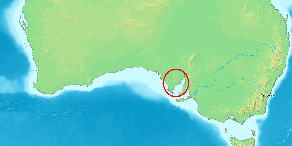 Location of Spencer Gulf in Australia | |
 Spencer Gulf  Spencer Gulf | |
| Location | South Australia |
| Coordinates | 34°25′S 136°45′E |
| Type | Gulf |
| Part of | Great Australian Bight |
| Basin countries | Australia |
The largest towns on the gulf are Port Lincoln, Whyalla, Port Pirie, and Port Augusta. Smaller towns on the gulf include Tumby Bay, Port Neill, Arno Bay, Cowell, Port Germein, Port Broughton, Wallaroo, Port Hughes, Port Victoria, Port Rickaby, Point Turton, and Corny Point.
History
The first recorded exploration of the gulf was that of Matthew Flinders in February 1802. Flinders navigated inland from the present location of Port Augusta to within 44–39 km (27–24 mi) of the termination of the water body.[1]
The gulf was named Spencer's Gulph by Flinders on 20 March 1802, after George John Spencer, the 2nd Earl Spencer.[2] The Baudin expedition visited the gulf after Flinders with Nicholas Baudin giving it the name Golfe Bonaparte and Louis de Freycinet using the name Golfe de la Melomanie on the expedition's published charts.[3]
By the 1830s, the natural harbour of Port Lincoln had become the site of an unofficial settlement, due in part to its convenience as a base for whaling vessels – which had long operated in the Great Australian Bight. Prior to the selection of Adelaide, some consideration was given to Port Lincoln as the potential site of a capital city.[citation needed]
Geography and topography
The Gulf is 77 km (48 mi) wide at its mouth (from Cape Catastrophe to Cape Spencer) and 320 km (200 mi) long (from its mouth to Port Augusta). The western shore of the gulf is the Eyre Peninsula, while the eastern side is the Yorke Peninsula, which separates it from the smaller Gulf St Vincent. Its entrance was defined by Matthew Flinders in 1802 as a line from Cape Catastrophe on Eyre Peninsula to Cape Spencer on Yorke Peninsula.[2] At the time of Flinders' exploration the gulf was noted to extend 298 km (185 mi) inland from a point near the Port Augusta crossing.[1] This so-called extension of the gulf consists of a land depression and occasional watercourse known as the Pirie–Torrens corridor, and the inland waterbody Lake Torrens.
The northern end of the gulf is spanned by the Joy Baluch AM Bridge between Port Augusta and Port Augusta West and further north by Yorkey Crossing.
Informal names for subdivisions of the gulf waters are sometimes used. "Northern Spencer Gulf" refers to waters north of Wallaroo and Arno Bay, while "Southern Spencer Gulf" refers to waters south of that line, extending to the mouth of the gulf. "Upper Spencer Gulf" includes the waters north of Port Pirie, and includes the three towns sometimes referred to as the Iron Triangle: Whyalla, Port Augusta and Port Pirie. Its boundary lacks precise definition.
Wildlife

The land surrounding the gulf, consisting of the Eyre and Yorke Peninsulas, is the Eyre Yorke Block bioregion. This was originally wooded shrubland but has now mainly been cleared for agriculture. The arid Gawler bioregion extends to the Spencer Gulf on the north-west. Many of South Australia's iconic marine species can be found on the shores and in the waters of Spencer Gulf.
Marine species
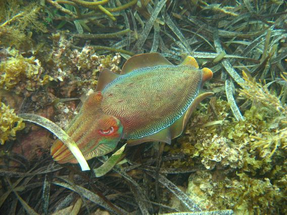
The rocky inshore reef along the coast near Port Bonython and Point Lowly is a breeding ground for the Northern Spencer Gulf population of Australian giant cuttlefish.[4][5][6] They are a favorite food of local bottlenose dolphins, who have developed sophisticated techniques for safely eating these creatures.[7] The Upper Spencer Gulf is also known for its snapper and Yellowtail kingfish fishing.[8] Great white sharks are sometimes seen in Spencer Gulf by fishermen, and shark cage diving and surface tours operate out of Port Lincoln.
A relic population of tiger pipefish (Filicampus tigris), a subtropical species is range limited to Northern Spencer Gulf.[9]
Marine mammals
Visiting southern right whales and humpback whales enter Spencer Gulf from June through to October, and can be seen as far north as Point Lowly and Port Augusta.[10] New Zealand fur seals and Australian sea lions can be found in southern Spencer Gulf, with significant breeding colonies located at Dangerous Reef and in the Sir Joseph Banks Group. Occasional sightings occurring in Northern Spencer Gulf. Bottlenose dolphins can be seen in the gulf's waters year-round.
Seabirds
Breeding colonies of little penguins exist on islands in Spencer Gulf. The northernmost colonies are located at Lipson Island and Wardang Island. In 2004, the Wardang Island colony's population was approximately 8,000 penguins.[11] Cape Barren geese and several species of cormorants also breed on islands in Spencer Gulf.
Islands
Spencer Gulf contains a number of inshore and offshore islands. These include (from north to south):
- Curlew Island (south of Port Augusta)
- Weeroona Island (north of Port Pirie)
- Shag Island (north of Port Broughton)
- Entrance Island (near Cowell)
- Bird Islands (near Wallaroo)
- Lipson Island (north of Tumby Bay)
- Tumby Island (south of Tumby Bay)
- Wardang Island & the Goose Island group (near Port Victoria)
- The Sir Joseph Banks Group (offshore from Tumby Bay)
- Louth Island & Rabbit Island (in Louth Bay)[12]
- Boston Island (in Boston Bay)[12]
- Grantham Island and Bicker Isles (in Proper Bay)[12]
- Donington Island, Carcase Rock, Owen Island, Taylor Island, Grindal Island, Little Island, Lewis Island, Smith Island, Hopkins Island and Thistle Island (east of the Jussieu Peninsula).[12]
- Middle Island, South Island and Royston Island (in Pondalowie Bay)
- Gambier Islands including Wedge Island (in the mouth of Spencer Gulf)
Port Development Proposals
Due to its proximity to many identified mineral deposits in South Australia's Far North, Eyre Peninsula and Braemar regions, there are multiple new port and harbor developments proposed for the region.
These include new or expanded facilities at (from north to south):
- Port Bonython - Port Bonython Bulk Commodities Export Facility - Spencer Gulf Port Link (proposed 2012)[13]
- Port Playford - Iron ore transshipment port proposed to be constructed on the site of the former Playford A Power Station, south of Port Augusta
- Whyalla - Inner harbour expansion - Arrium (completed 2013)[14]
- Port Pirie - Possible expansion for trans-shipment of iron ore from the Braemar region (concept stage)[15]
- Lucky Bay - Lucky Bay Common User Export Facility (harbour expansion) - SeaSA (proposed 2013, construction commenced 2014)[16]
- Myponie Point - Possible port location for Braemar region mineral exports (concept stage)[17]
- Cape Hardy - Iron Road Limited (proposed 2013)[18]
- Lipson Cove - Port Spencer (formerly known as Sheep Hill) - Centrex Metals (proposed 2011)[19] The port could be completed in 2023.[20]
Seawater desalination plants
As of 2016[update], one reverse osmosis and one thermal seawater desalination plant draw water from Spencer Gulf. Several others are planned. All currently or will produce water primarily or exclusively for industrial use. They are:
| Location | Company | Production capacity (GL/year) | Purpose | Status |
|---|---|---|---|---|
| Whyalla | Arrium | 1.6 | Whyalla Steelworks industrial supply | Commissioned 2011, operating[21] |
| Port Augusta | Sundrop Farms | 3 | Growing vegetables | Operational in October 2016[22][23][24][25] |
| Point Lowly | BHP | 100 | Olympic Dam mine mineral processing | Approved 2011, not constructed[26] |
| Lipson Cove | Centrex Metals | 5-20 | For iron ore slurry pipeline | Proposed 2013[27] |
| Myponie Point | Braemar Alliance | 20[28]-50[29] | For iron ore slurry pipeline | Concept stage[28][29][30] |
Spencer Gulf in Film & Video
The Spencer Gulf region, its wildlife and its development are the subjects of a documentary film in production entitled Cuttlefish Country.[31]
Protected areas
Reserves declared by the South Australian government
Aquatic Reserves
Spencer Gulf contains four aquatic reserves.
Blanche Harbour-Douglas Bank Aquatic Reserve which is located in west side of Spencer Gulf, north of Whyalla, was declared in 1980 ‘for fisheries management, protection of its mangrove-seagrass communities and associated fish nursery areas.’[32][33]
Goose Island Aquatic Reserve which is located at Goose Island on the east side of Spencer Gulf near Port Victoria was declared in 1971 to provide ‘a conservation area where teaching institutions may conduct classes and scientific research on marine biology and ecology and to protect the habitat of the seal colony situated on White Rocks.’[32][34]
Whyalla - Cowleds Landing Aquatic Reserve which is located in on the west side of Spencer Gulf, just south of Whyalla, was declared in 1980 to ‘protect the mangrove-seagrass communities and associated fish nursery areas.’[32][35]
Yatala Harbour Upper Spencer Gulf Aquatic Reserve which is located in Yatala Harbour on the east side of Spencer Gulf, north of Port Pirie, was declared in 1980 for ‘the protection of its mangrove-seagrass communities and associated fish nursery areas.’[32][36]
Marine Parks
Spencer Gulf contains five marine parks, each with its own outer boundary and internal zoning. Fishing is prohibited with Sanctuary Zones, and detailed maps and GPS coordinates for the parks are available from the Government of South Australia's Department of Environment, Water & Natural Resources.[37]
The marine parks within Spencer Gulf are (from north to south):
- Upper Spencer Gulf Marine Park[38]
- Franklin Harbor Marine Park[39]
- Eastern Spencer Gulf Marine Park[39]
- Sir Joseph Banks Group Marine Park[40]
- Southern Spencer Gulf Marine Park[41]
Terrestrial reserves
A number of terrestrial reserves either adjoin Spencer Gulf at low water or are located on islands within the gulf. On the west coast of the gulf, from north to south, they are Munyaroo Conservation Park, Franklin Harbor Conservation Park, Lipson Island Conservation Park, Tumby Island Conservation Park, Sir Joseph Banks Group Conservation Park, Lincoln National Park and Memory Cove Wilderness Protection Area. On the east coast of the gulf, from north to south, they are Winninowie Conservation Park, Bird Islands Conservation Park, Goose Island Conservation Park, Leven Beach Conservation Park and Innes National Park. At the mouth of the gulf, the Gambier Islands Conservation Park is located within the Gambier Islands group.
Non-statutory arrangements
Important Bird Areas
Three Important Bird Areas (IBAs) have been nominated by BirdLife International at locations in Spencer Gulf. The Spencer Gulf Important Bird Area lies along the north-eastern coast of the Gulf; it comprises a 460 square kilometres (180 square miles) strip of coastal land consisting mainly of intertidal mudflats, mangroves and salt marshes. It was identified as an IBA by BirdLife International because of its importance for the conservation of waders, or shorebirds. The other two IBAs within Spencer Gulf are located in the Sir Joseph Banks Group and at Goose Island. Both sites contain breeding colonies of various island seabird species.[42]
Gallery
 The harbor of Port Broughton on the Eastern shore of Spencer Gulf
 Spencer Gulf seen from one of NASA's Satellites
 Moonta Bay Jetty on the Eastern shore of Spencer Gulf


References
- "Spencer's Gulf". The Edinburgh Gazetteer, or Geographical Dictionary ... A. Constable and Company. 5: 713. 1822 – via Harvard University.
Spencer's Gulf, a large gulf on the south coast of New Holland, which extends 185 miles into the interior of the country, in a direction north-north-east. The entrance of the gulf from Cape Catastrophe on the west, and Cape Spencer on the east, is 48 miles wide. It was explored to within seven or eight leagues of its termination by captain Flinders, who then saw land at a distance before him. Cape Spencer lies in Long. 136. 55. E. Lat. 35. 18. S.
- Flinders, Matthew (1966) [1814]. A Voyage to Terra Australis : undertaken for the purpose of completing the discovery of that vast country, and prosecuted in the years 1801, 1802, and 1803 in His Majesty's ship the Investigator, and subsequently in the armed vessel Porpoise and Cumberland Schooner; with an account of the shipwreck of the Porpoise, arrival of the Cumberland at Mauritius, and imprisonment of the commander during six years and a half in that island (Facsimile ed.). Adelaide: Libraries Board of South Australia. p. 249. Retrieved 27 March 2013.
- Manning, Geoffrey. "South Australian Names - T" (PDF). Manning Index of South Australian History. State Library of South Australia. Retrieved 9 August 2019.
- "Cross-dressing cuttlefish to sex up tourism". www.adelaide.edu.au.
- Sepia apama: the giant Australian cuttlefish
- "Whyalla Cuttlefish". whyallacuttlefish.com. Archived from the original on 2008-11-20.
- "Catch cuttlefish, drain off the ink, then fillet. Serves five". independent.co.uk. 31 January 2009. Archived from the original on 2022-05-24.
- Snapper Fishing Archived 2008-12-08 at the Wayback Machine
- Occurrence search results - Filicampus tigris - Tiger Pipefish Atlas of Living Australia. Accessed 2013-12-24.
- Ladgrove, Petria "Whales spotted at Port Augusta" ABC North & West, 2010-07-06. Accessed 2013-12-24.
- Wiebken, A. Conservation Priorities for Little Penguin Populations in Gulf St Vincent Archived 2014-02-22 at the Wayback Machine SARDI, South Australia (2011-06). Retrieved 2014-01-26.
- Royal Australian Navy Hydrographic Service Hydrographic Department (1983). Port Lincoln and approaches (chart no. Aus 134).
- South Australian Government - Major Development Proposals "Port Bonython Bulk Export Facility near Whyalla" Retrieved 2013-11-05.
- "Whyalla's extended harbor opens gate to China for iron ore" The Advertiser (2013-07-29) Retrieved 2013-11-05.
- Flinders Ports South Australia "Iron ore boost in sight for Port Pirie" Retrieved 2013-11-05.
- "Regional Development Australia Fund - Round 2 Project Fact Sheet - Lucky Bay Harbor Extension" Retrieved 2013-11-05.
- "Big plans in the pipeline" Yorke Peninsula Country Times (2013-10-01) Retrieved 2013-11-05.
- South Australian Government - Major Development Proposals "Cape Hardy deep sea port" Retrieved 2013-11-05.
- South Australian Government - Major Development Proposals "Sheep Hill deep water port facility (Stage 1) on Eyre Peninsula" Retrieved 2013-11-05.
- "New grain port given go ahead, but concerns remain for penguin colony". ABC News. 5 May 2022.
- "Desalination plant commissioned at Onesteel Whyalla" Osmoflo (2011-12-02). Retrieved 2014-01-29.
- Condliffe, Michael Reilly and Jamie. "A solar-powered farm is using seawater to grow tomatoes in the desert". technologyreview.com.
- "£120m state-of-the-art-tomato farm opens in Australia - Farmers Weekly". fwi.co.uk. 6 October 2016.
- "First farm to grow veg in a desert using only sun and seawater". New Scientist. 2016-10-06.
- "Council Development Assessment Panel Agenda - Meeting #123" (PDF). Port Augusta City Council. 2014-08-12. Retrieved 2014-10-23.
- "Olympic Dam expansion EIS overview information sheet" BHP (2009-04-08). Retrieved 2014-01-29.
- EPBC Act > Referral Detail > Centrex Metals Port Spencer Department of Environment, Government of Australia (2012-10-18). Retrieved 2014-01-2
- "Razorback project returns a positive PFS" Royal Resources (2013-01-30). Retrieved 2014-01-29.
- Russell, Christopher (2011-07-08). "Gulf desal in $7bn iron mine plans for Braemar iron ore province". The Advertiser. Retrieved 2014-12-03.
- "Regional Mining and Infrastructure Planning project - Yorke and MidNorth/Braemar Interim report maps" (PDF). Deloitte. 2013. Retrieved 2014-12-03.
- Cuttlefish Country IMDb Retrieved 23 September 2020.
- "Summary of SA Marine Protected Areas by Type (see 'SA Reserve List' tab)". Australian Government - Department of the Environment. 10 February 2003. Retrieved 10 October 2016.
- Primary Industries and Regions South Australia (PIRSA) (2007), Aquatic Reserve: Blanche Harbour (PDF), Primary Industries and Regions South Australia, archived from the original (PDF) on 2015-04-05
- Primary Industries and Regions South Australia (PIRSA) (2007), Aquatic Reserve: Goose Island (PDF), Primary Industries and Regions South Australia, archived from the original (PDF) on 2015-04-05
- Primary Industries and Regions South Australia (PIRSA) (2007), Aquatic Reserve: Cowleds Landing (PDF), Primary Industries and Regions South Australia, archived from the original (PDF) on 2015-04-05
- Primary Industries and Regions South Australia (PIRSA) (2007), Aquatic Reserve: Yatala Harbour (PDF), Primary Industries and Regions South Australia
- Marine Parks, Department of Environment, Water & Natural Resources, Government of South Australia
- "Upper Spencer Gulf marine park zones". Department of Environment, Water and Natural Resources. Retrieved 6 December 2013.
- "Franklin Harbor". Department of Environment, Water and Natural Resources. Retrieved 6 December 2013.
- "Sir Joseph Banks Group Marine Park". Department of Environment, Government of South Australia. Retrieved 6 December 2013.
- "Southern Spencer Gulf". Department of Environment, Water and Natural Resources, Government of South Australia. Retrieved 6 December 2013.
- Dutson, Guy; Garnett, Stephen; Gole, Cheryl (October 2009). Australia's Important Bird Areas, Key sites for bird conservation (PDF). Birds Australia. p. 33. Retrieved 5 October 2014.
External links
 Media related to Spencer Gulf at Wikimedia Commons
List of Australian seas | |
|---|---|
| Ocean |
|
| Sea | |
| Strait |
|
| Gulf | |
На других языках
- [en] Spencer Gulf
[ru] Спенсер (залив)
Спенсер (англ. Spencer Gulf) — залив в южной части Австралии, омывающий берег штата Южная Австралия и объединённый с водами Большого Австралийского залива. Длина залива Спенсер составляет 322 км, а ширина при входе в залив — 129 км. В западной части залив омывает полуостров Эйр, а в восточной — полуостров Йорк, который отделяет его от небольшого залива Св. Винсента. На берегу залива Спенсер расположены такие города, как Уайалла, Порт-Пири и Порт-Огаста.Другой контент может иметь иную лицензию. Перед использованием материалов сайта WikiSort.org внимательно изучите правила лицензирования конкретных элементов наполнения сайта.
WikiSort.org - проект по пересортировке и дополнению контента Википедии