geo.wikisort.org - Island
West Island (Malay: Pulau Panjang, Cocos Malay: Pulu Panjang), part of the South Keeling Islands, is the capital of the Cocos (Keeling) Islands, an Australian external territory in the Indian Ocean. The population is roughly 120 making it the third smallest capital in the world, and consists mainly of Europeans. It is less populous than Home Island, the only other inhabited island.
Native name: | |
|---|---|
 Cocos (Keeling) Islands Airport, on West Island | |
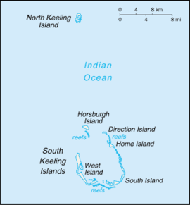 The Cocos (Keeling) Islands, showing West Island | |
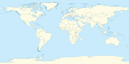 West Island West Island in the Indian Ocean | |
| Geography | |
| Location | Indian Ocean |
| Coordinates | 12°11′13″S 96°49′42″E |
| Archipelago | Cocos (Keeling) Islands |
| Area | 6.23 km2 (2.41 sq mi) |
| Administration | |
Australia | |
| External territory of Australia | Australian Indian Ocean Territories |
| Territory | Cocos (Keeling) Islands |
| Capital city | Canberra |
| Demographics | |
| Population | 120 |
| Languages | |
| Additional information | |
| Time zone |
|
West Island was part of the Clunies-Ross plantation and an airstrip was built here during World War II. As well as all the government buildings, it contains the airport, a general store and tourist accommodation. In November 2013 it was revealed that the Australian Signals Directorate operates a listening station on West Island.[1]
Education
Cocos Islands District High School operates a primary and secondary campus on West Island. Most of the students of that campus originate from the Australian continent.[2]
Heritage listings
West Island contains a number of heritage-listed sites, including:
- Morea Close: Administration Building Forecourt[3]
- Air Force Road: Direction Island Houses[4]
- Qantas Close: Government House[5]
- Sydney Highway: Qantas Huts[6]
- RAAF Memorial[7]
- Air Force Road: Type 2 Residences[8]
- William Keeling Crescent: Type T Houses Precinct[9]
- Orion Close: West Island Elevated Houses[10]
- Air Force Road: West Island Housing Precinct[11]
- Alexander Street: West Island Mosque[12]
Climate
West Island experiences a tropical rainforest climate (Köppen: Af, Trewartha: Aral), with hot and humid conditions experiences year round. The islands experience two seasons that often overlap: the trade wind season from May/June to September/October, and the calmer doldrum season from November through to May.[13] Precipitation is moderate to high year round, thanks to its position at the southern edge of the equatorial low pressure belt. North-west monsoons deliver rain during the doldrum, while the southeastern trade winds also give rain for much of the year.[14] Cyclones have the potential to seriously effect the flora and fauna on the island. The 1989-90 South-West Indian Ocean cyclone season caused damage to the islands, with Tropical Cyclone Walter hitting the island around the 13th of March 1990.[15] Extreme temperatures however, are subdued by the influence of the Indian Ocean. Extremes only range from 32.8 °C (91.0 °F) on 23 February 2017 to 20.4 °C (68.7 °F) on 27 December 2018.
| Climate data for Cocos Island Airport (1991-2020 normals, extremes 1998-present) | |||||||||||||
|---|---|---|---|---|---|---|---|---|---|---|---|---|---|
| Month | Jan | Feb | Mar | Apr | May | Jun | Jul | Aug | Sep | Oct | Nov | Dec | Year |
| Record high °C (°F) | 32.2 (90.0) |
32.8 (91.0) |
32.7 (90.9) |
32.8 (91.0) |
31.6 (88.9) |
30.9 (87.6) |
30.3 (86.5) |
30.6 (87.1) |
30.1 (86.2) |
31.0 (87.8) |
31.1 (88.0) |
31.6 (88.9) |
32.8 (91.0) |
| Average high °C (°F) | 30.1 (86.2) |
30.2 (86.4) |
30.2 (86.4) |
30.0 (86.0) |
29.5 (85.1) |
28.8 (83.8) |
28.3 (82.9) |
28.1 (82.6) |
28.3 (82.9) |
28.8 (83.8) |
29.2 (84.6) |
29.5 (85.1) |
29.2 (84.6) |
| Daily mean °C (°F) | 27.7 (81.9) |
27.8 (82.0) |
27.9 (82.2) |
27.9 (82.2) |
27.5 (81.5) |
26.9 (80.4) |
26.4 (79.5) |
26.2 (79.2) |
26.3 (79.3) |
26.7 (80.1) |
27.1 (80.8) |
27.2 (81.0) |
27.1 (80.8) |
| Average low °C (°F) | 25.2 (77.4) |
25.4 (77.7) |
25.5 (77.9) |
25.7 (78.3) |
25.5 (77.9) |
25.0 (77.0) |
24.4 (75.9) |
24.3 (75.7) |
24.4 (75.9) |
24.6 (76.3) |
24.9 (76.8) |
24.9 (76.8) |
25.0 (77.0) |
| Record low °C (°F) | 21.0 (69.8) |
21.8 (71.2) |
21.8 (71.2) |
21.9 (71.4) |
21.2 (70.2) |
22.2 (72.0) |
20.6 (69.1) |
20.9 (69.6) |
20.9 (69.6) |
21.2 (70.2) |
21.6 (70.9) |
20.4 (68.7) |
20.4 (68.7) |
| Average precipitation mm (inches) | 151.7 (5.97) |
207.1 (8.15) |
239.4 (9.43) |
249.3 (9.81) |
187.7 (7.39) |
187.3 (7.37) |
180.9 (7.12) |
102.4 (4.03) |
86.2 (3.39) |
84.8 (3.34) |
89.7 (3.53) |
121.4 (4.78) |
1,886.6 (74.28) |
| Average precipitation days (≥ 1 mm) | 10.2 | 12.2 | 15.4 | 14.1 | 13.9 | 13.9 | 14.7 | 11.1 | 8.4 | 6.2 | 6.3 | 8.6 | 135.0 |
| Source: Australian Bureau of Meteorology[16] | |||||||||||||
See also
- Direction Island, Cocos (Keeling) Islands
- Home Island
- Horsburgh Island
- North Keeling
References
- Dorling, Philip (1 November 2013). "Listening post revealed on Cocos Islands". Canberra Times.
- Home. Cocos Islands District High School. Retrieved on 8 April 2019.
- "Administration Building Forecourt (Place ID 105356)". Australian Heritage Database. Australian Government. Retrieved 15 May 2019.
- "Direction Island (DI) Houses (Place ID 105358)". Australian Heritage Database. Australian Government. Retrieved 15 May 2019.
- "Government House (Place ID 105360)". Australian Heritage Database. Australian Government. Retrieved 15 May 2019.
- "Qantas Huts (former) (Place ID 105354)". Australian Heritage Database. Australian Government. Retrieved 15 May 2019.
- "RAAF Memorial (Place ID 105353)". Australian Heritage Database. Australian Government. Retrieved 15 May 2019.
- "Type 2 Residences (Place ID 105357)". Australian Heritage Database. Australian Government. Retrieved 15 May 2019.
- "Type T Houses Precinct (Place ID 105408)". Australian Heritage Database. Australian Government. Retrieved 15 May 2019.
- "West Island Elevated Houses (Place ID 105359)". Australian Heritage Database. Australian Government. Retrieved 15 May 2019.
- "West Island Housing Precinct (Place ID 105223)". Australian Heritage Database. Australian Government. Retrieved 15 May 2019.
- "West Island Mosque (Place ID 105219)". Australian Heritage Database. Australian Government. Retrieved 15 May 2019.
- "Weather & Tides | Cocos Keeling Islands". www.cocoskeelingislands.com.au. Retrieved 23 April 2022.
- "Climate - DAWE". www.awe.gov.au. Retrieved 23 April 2022.
- "Tropical Cyclone WALTER". australiasevereweather.com. Retrieved 23 April 2022.
- "Cocos Island Airport Climate". Australian Bureau of Meteorology.
This Cocos (Keeling) Islands geography article is a stub. You can help Wikipedia by expanding it. |
На других языках
[de] West Island (Kokosinseln)
Die Insel West Island, auch Pulau Panjang genannt, ist die Hauptinsel und mit 6,23 km² auch die größte Insel des Australischen Außengebietes der Kokosinseln. West Island ist eine Insel des Atolls South Keeling Islands. Die Inselgruppe liegt etwa 2.930 km nordwestlich von Perth, 3.685 km westlich von Darwin, 960 km südwestlich der Weihnachtsinsel und mehr als 1.000 km südwestlich von Java und Sumatra entfernt. Der nächstgelegene Festlandspunkt Australiens ist das Kap Low Point auf der Halbinsel North West Cape in einer Entfernung von etwa 2.100 km.- [en] West Island, Cocos (Keeling) Islands
[es] West Island (Islas Cocos)
West Island[1] es la capital del territorio externo australiano de las Islas Cocos (Keeling).[2][3] La población es de aproximadamente 120 habitantes. Es además la menos poblada de las dos islas habitadas de ese archipiélago (la otra es Isla Home). Formó parte de las posesiones de la familia Clunies-Ross, y durante la Segunda Guerra Mundial un aeropuerto militar funcionó aquí. Además de edificios gubernamentales, un comercio de ramos generales y un pequeño aeropuerto, cuenta con instalaciones turísticas.[it] West Island
West Island anche chiamata Pulau Panjang è l'isola principale dell'arcipelago delle Isole Cocos. Fa parte dell'atollo South Keeling Islands, uno dei due che compongono l'arcipelago.[ru] Уэст-Айленд
Уэ́ст-А́йленд (англ. West Island) — столица Кокосовых островов, которые входят в состав Внешней территории АвстралияДругой контент может иметь иную лицензию. Перед использованием материалов сайта WikiSort.org внимательно изучите правила лицензирования конкретных элементов наполнения сайта.
WikiSort.org - проект по пересортировке и дополнению контента Википедии