geo.wikisort.org - Island
Siple Island is a 110 km (68 mi) long snow-covered island lying east of Wrigley Gulf along the Getz Ice Shelf off Bakutis Coast of Marie Byrd Land, Antarctica. Its centre is located at 73°51′S 125°50′W.
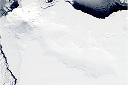
 October 2002 satellite photograph of Siple Island | |
 Siple Location of Siple Island | |
| Geography | |
|---|---|
| Location | Antarctica |
| Coordinates | 73°51′S 125°50′W |
| Area | 6,390 km2 (2,470 sq mi) |
| Area rank | 100th |
| Length | 110 km (68 mi) |
| Highest elevation | 3,110 m (10200 ft) |
| Highest point | Mount Siple |
| Administration | |
| Administered under the Antarctic Treaty System | |
| Demographics | |
| Population | Uninhabited |
Its area is 6,390 km2 (2,467 sq mi) and it is dominated by the dormant shield volcano Mount Siple, rising to 3,110 m (10,203 ft) — making this the 15th ranking island in the world by maximum elevation.
The feature was first indicated as an island on U.S. Geological Survey (USGS) maps compiled from ground surveys and U.S. Navy air photos, 1959–65.
Island and mountain were named by the United States Advisory Committee on Antarctic Names (US-ACAN) in 1967 in honour of the American Antarctic explorer Paul A. Siple (1909–1968), member of Admiral Byrd's expeditions.
Geographic features
- The Blob - mound-shaped knoll
- Recely Bluff - bluff on northeast slope of Mount Siple.
See also
- Composite Antarctic Gazetteer
- List of Antarctic and sub-Antarctic islands
- List of Antarctic islands south of 60° S
- List of volcanoes in Antarctica
- Scientific Committee on Antarctic Research
- Territorial claims in Antarctica
References
 This article incorporates public domain material from the United States Geological Survey document: "Siple Island". (content from the Geographic Names Information System)
На других языках
[de] Siple-Insel
Die Siple-Insel (englisch Siple Island) ist eine permanent schneebedeckte, unbewohnte Insel in Westantarktika. Sie wird durch das Getz-Schelfeis von der Bakutis-Küste des Marie-Byrd-Landes getrennt. Die Entfernung zum Festland über das Schelfeis beträgt rund 50 km. Die rund 150 km lange Insel mit einer Fläche von etwa 6390 km² wird im Nordwesten vom 3110 m hohen Mount Siple, einem inaktiven Vulkan, dominiert. Entsprechend der Lage der Insel ist das Klima polar und von starken Winden geprägt.- [en] Siple Island
[es] Isla Siple
Isla Siple Ubicación geográficaContinente AntártidaOcéano AntárticoCoordenadas 73°39′S 125°12′OUbicación administrativaPaís Tratado Antártico, Terra nullius (no reclamada por ningún país)División Región del Tratado AntárticoCaracterísticas generalesSuperficie 6390 km²Longitud 110 kmAnchura máxima 62 kmPunto más alto Monte Siple (3 110 metros)PoblaciónPoblación 0 hab. ()[editar datos en Wikidata] La isla Siple es una isla cubierta de nieve de 110 kilómetros de largo al este del golfo de Wrigley a lo largo de la barrera de hielo de Getz, en la costa de Bakutis, en la Tierra de Marie Byrd, Antártida. Su centro está localizado en las 73°39′S 125°12′O. La isla Siple no es reclamada por ningún país.[fr] Île Siple
L'île Siple est une île de l'Antarctique.[it] Isola Siple
L'isola Siple è un'isola antartica coperta dalla neve, di ampiezza massima pari a 110 km, situata ad est del golfo di Wrigley, lungo la piattaforma glaciale Getz e al largo della costa di Bakutis, nella Terra di Marie Byrd. L'area dell'isola è di 6.390 km² ed è dominata dal monte Siple, un vulcano dormiente alto 3.110 metri.[ru] Сайпл (остров)
Сайпл (англ. Siple Island) — остров в Южном океане на границе морей Амундсена и Росса.Другой контент может иметь иную лицензию. Перед использованием материалов сайта WikiSort.org внимательно изучите правила лицензирования конкретных элементов наполнения сайта.
WikiSort.org - проект по пересортировке и дополнению контента Википедии