geo.wikisort.org - Island
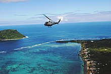
Nuʻutele is an island that consists of a volcanic tuff ring. It lies 1.3 km off the eastern end of Upolu island, Samoa. It is the largest of the four Aleipata Islands, with an area of 1.15 km2 (0.44 sq mi).
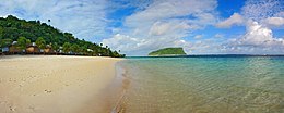
 Nuʻutele island viewed from Lalomanu beach, 2007 | |
| Geography | |
|---|---|
| Area | 1.15 km2 (0.44 sq mi) |
| Coastline | 5.04 km (3.132 mi) |

Nuʻutele, together with Nuʻulua, a smaller island in the Aleipata group, are significant conservation areas for native species of bird life. Nuʻutele features steep terrain, with vertical marine cliffs up to 180 m high.[1]
Nuʻutele is famous as a highly appreciated scenic landmark when viewed in the distance from the popular Lalomanu beach area on nearby Upolu Island, across the water.

See also
- Samoa Islands
- List of islands
- Desert island
Notes
- "Upolu". Global Volcanism Program. Smithsonian Institution. (includes Nu'utele)
- Some information about Nu'utele and Nu'ulua.
References
На других языках
[de] Nuʻutele
Nuʻutele ist eine unbewohnte Insel der Aleipata-Inseln im Osten von Samoa. Sie gehört administrativ zum Distrikt Atua.- [en] Nuʻutele
[ru] Нуутеле
Нуутеле (англ. Nu'utele) — остров вулканического происхождения, расположенный в 1,3 км восточнее острова Уполу (Самоа). Это крупнейший из островов архипелага Алеипата, площадью 1,08 км².Текст в блоке "Читать" взят с сайта "Википедия" и доступен по лицензии Creative Commons Attribution-ShareAlike; в отдельных случаях могут действовать дополнительные условия.
Другой контент может иметь иную лицензию. Перед использованием материалов сайта WikiSort.org внимательно изучите правила лицензирования конкретных элементов наполнения сайта.
Другой контент может иметь иную лицензию. Перед использованием материалов сайта WikiSort.org внимательно изучите правила лицензирования конкретных элементов наполнения сайта.
2019-2025
WikiSort.org - проект по пересортировке и дополнению контента Википедии
WikiSort.org - проект по пересортировке и дополнению контента Википедии
