geo.wikisort.org - Island
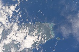
Fanuatapu, an uninhabited island, is a volcanic tuff ring off the eastern tip of Upolu Island, Samoa. It is the smallest and easternmost of the four Aleipata Islands, with an area of 15 hectares. It has an automated lighthouse.
 Satellite image of the Aleipata Islands | |
| Geography | |
|---|---|
| Area | 0.06 km2 (0.023 sq mi) |
| Coastline | 1.79 km (1.112 mi) |
See also
- Samoa Islands
- List of islands
- Desert island
References
- "Upolu". Global Volcanism Program. Smithsonian Institution. (includes Fanuatapu)
На других языках
[de] Fanuatapu (Samoa)
Fanuatapu ist eine kleine unbewohnte Insel der Aleipata-Inseln im Osten von Samoa. Sie gehört administrativ zum Distrikt Atua.- [en] Fanuatapu
Текст в блоке "Читать" взят с сайта "Википедия" и доступен по лицензии Creative Commons Attribution-ShareAlike; в отдельных случаях могут действовать дополнительные условия.
Другой контент может иметь иную лицензию. Перед использованием материалов сайта WikiSort.org внимательно изучите правила лицензирования конкретных элементов наполнения сайта.
Другой контент может иметь иную лицензию. Перед использованием материалов сайта WikiSort.org внимательно изучите правила лицензирования конкретных элементов наполнения сайта.
2019-2025
WikiSort.org - проект по пересортировке и дополнению контента Википедии
WikiSort.org - проект по пересортировке и дополнению контента Википедии
