geo.wikisort.org - Island
The Medvezhyi Islands, or Bear Islands (Russian: Медве́жьи острова́; Yakut: Эhэлээх арыылар, Eheleex Arıılar) is an uninhabited group of islands at the western end of the Kolyma Gulf of the East Siberian Sea.
Medvezhyi Islands
Эhэлээх арыылар Медве́жьи острова́ | |
|---|---|
Island group | |
 Map of the Medvezhiy Islands. | |
 | |
 Medvezhyi Islands | |
| Coordinates: 70°52′N 161°26′E | |
| Country | Russian Federation |
| Federal subject | Far Eastern Federal District |
| Republic | Sakha Republic |
History
The first recorded European to report the existence of the Medvezhyi Islands was Russian explorer Yakov Permyakov in 1710. While sailing from the Lena to the Kolyma River, Permyakov observed the silhouette of the unknown island group in the then little explored East Siberian Sea.
In 1820-1824, during Ferdinand Wrangel's Arctic expedition to the East Siberian Sea and the Chukchi Sea, Arctic explorer Fyodor Matyushkin surveyed and mapped Chetyryokhstolbovoy Island in the Medvezhyi group.
On September 3, 1878, Adolf Erik Nordenskiöld recorded that he sailed close to the island group in the steamship Vega. This report was made during the famous expedition that made the whole length of the Northeast passage for the first time in history.[1]
The group was also explored during the Arctic Ocean Hydrographic Expedition of 1910–1915.[2]
Geography
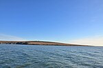
The Medvezhyi Islands are located about 100 kilometres (55 nautical miles) north of the mouths of the Kolyma River. They are part of the East Siberian Lowland.[3] The coast of Siberia is about 35 km (19 nmi) southwest of Krestovsky, the largest island, which is about 15 km (9+1⁄2 mi) in length.
The sea surrounding the Medvezhyi Islands is covered with fast ice in the winter and the climate is severe. The surrounding sea is obstructed by pack ice even in the summer months. There is commercial fishing in the area of the islands during the summer.[4]
This island group is a part of the territory of the Sakha Republic of Russia. As their name indicates, these islands are a refuge and breeding ground for polar bears.
Islands
There are six islands in the group: Krestovsky, Leontyev, Pushkarev, Lysova, Andreev and Chetyryokhstolbovoy, where there is a polar station which was inaugurated in 1933.[5] The islands are formed of stacked granite, clay and shale. They are mostly covered with tundra vegetation.[6]
Climate
| Climate data for Medvezhyi Islands | |||||||||||||
|---|---|---|---|---|---|---|---|---|---|---|---|---|---|
| Month | Jan | Feb | Mar | Apr | May | Jun | Jul | Aug | Sep | Oct | Nov | Dec | Year |
| Daily mean °C (°F) | −28.7 (−19.7) |
−29.5 (−21.1) |
−26.7 (−16.1) |
−19.6 (−3.3) |
−7.0 (19.4) |
0.4 (32.7) |
2.2 (36.0) |
1.8 (35.2) |
−0.7 (30.7) |
−9.8 (14.4) |
−21.2 (−6.2) |
−26.8 (−16.2) |
−13.8 (7.2) |
| Average precipitation mm (inches) | 9.0 (0.35) |
6.7 (0.26) |
4.5 (0.18) |
5.0 (0.20) |
6.3 (0.25) |
10.0 (0.39) |
20.0 (0.79) |
21.1 (0.83) |
16.1 (0.63) |
14.7 (0.58) |
11.5 (0.45) |
7.4 (0.29) |
132.3 (5.21) |
| Average precipitation days (≥ 1.0 mm) | 3.0 | 1.7 | 1.3 | 1.1 | 1.0 | 2.5 | 4.0 | 5.5 | 5.3 | 5.1 | 3.3 | 1.8 | 35.6 |
| Mean monthly sunshine hours | 0 | 48 | 205 | 292 | 233 | 245 | 230 | 126 | 57 | 39 | 5 | 0 | 1,480 |
| Source: NOAA[7] | |||||||||||||
Features of the islands
 Chetyrokhstolbovoy Island (70°37‘50‘‘N, 162°22’30’’E)
 Kigilyakh stone pillars on Chetyrokhstolbovoy Island. Kigilyakh means "stone man" in Yakut.
 Kigilyakhs on Chetyrokhstolbovoy Island
 Chetyrokhstolbovoy Island (Polar Station)
 Chetyrokhstolbovoy Island
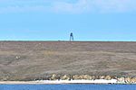 Krestovsky Island
(70°48’N, 160°40’E)


See also
- List of research stations in the Arctic
- Fyodor Matyushkin
- Amateur Radio Expedition to Leontyeva Island, Medvezhyi Islands RI0LI
References
- Albert Hastings Markham. Arctic Exploration, 1895
- The Arctic Ocean Hydrographic Expedition 1910-1915 Archived October 16, 2010, at the Wayback Machine
- Oleg Leonidovič Kryžanovskij, A Checklist of the Ground-beetles of Russia and Adjacent Lands. p. 16
- Commercial fishing Archived 2011-06-29 at the Wayback Machine
- История полярных арктических станций с 30-х годов XX века
- Geography Archived September 27, 2007, at the Wayback Machine
- "Cetyrehstolbovoj IL Climate Normals 1961–1990". National Oceanic and Atmospheric Administration. Retrieved 27 February 2016.
|
Authority control | |
|---|---|
| General |
|
| National libraries | |
На других языках
[de] Medweschji-Inseln
Die Medweschji- oder Bäreninseln (russisch Медвежьи острова) sind eine unbewohnte Inselgruppe am westlichen Ende des Kolyma-Golfes in der Ostsibirischen See.- [en] Medvezhyi Islands
[es] Islas Medvezhi
Las islas Medvezhi (o islas de los Osos), (en ruso, Медвежьи острова) es un grupo de islas deshabitadas del ártico siberiano, localizadas en el extremo occidental del golfo del Kolymá (Kolymski zaliv), en aguas del mar de Siberia Oriental.[fr] Îles Medveji
Les îles Medveji (en russe : Медвежьи острова, soit « Îles des ours ») sont un archipel de six îles inhabitées situées dans la mer de Sibérie orientale, mer bordière de l'océan Arctique. Ces îles sont situées au nord-est de la Sibérie (Russie) et sont administrativement rattachées à la République de Sakha, dans l'Extrême-Orient russe. L'île Krestovski est située à 35 km à l'est-nord-est du mys Krestovy, un cap de la côte continentale, et l'archipel dans son ensemble à environ 125 km au nord de l'estuaire de la Kolyma.[it] Isole Medvež'i
Le isole Medvež'i (in russo: острова Медвежьи, ostrova Medvež'i; in italiano "isole degli orsi") sono un gruppo di 6 isole nel mare della Siberia orientale, Russia. Amministrativamente appartengono al Nižnekolymskij ulus della Repubblica autonoma di Sacha-Jacuzia.[ru] Медвежьи острова
Медве́жьи острова́ (якут. Эһэлээх арыылар) — группа из 6 островов в Северном Ледовитом океане. Входят в состав Якутии. Расположены в Восточно-Сибирском море, к северу от устья реки Колымы. Общая площадь островов около 60 км².Другой контент может иметь иную лицензию. Перед использованием материалов сайта WikiSort.org внимательно изучите правила лицензирования конкретных элементов наполнения сайта.
WikiSort.org - проект по пересортировке и дополнению контента Википедии