geo.wikisort.org - Island
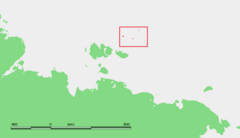
Henrietta Island (Russian: Остров Генриетты, tr. Ostrov Genriyetty; Yakut: Хенриетта Aрыыта, romanized: Xenriyetta Arııta) is the northernmost island of the De Long archipelago in the East Siberian Sea. Administratively it belongs to Yakutia of the Russian Federation.
 View of the shores of Henrietta Island. | |
 Henrietta is the northernmost island of the De Long group | |
| Geography | |
| Location | Arctic Ocean |
| Coordinates | 77°06′N 156°30′E |
| Archipelago | De Long Islands |
| Area | 15 km2 (5.8 sq mi) |
| Length | 6 km (3.7 mi) |
| Width | 5 km (3.1 mi) |
| Highest elevation | 312 m (1024 ft) |
| Highest point | Ice cap |
| Administration | |
Russia | |
| Federal Subject | Yakutia |
| Demographics | |
| Population | uninhabited |
Geography
Henrietta is roughly circular in shape with a diameter of about 5 to 6 km (3 to 4 mi) and area of about 15 km2 (5.8 sq mi). Its shoreline consists of 50 to 100 m (164 to 328 ft) high, continuous, and rocky seacliffs.[1] Cape Melville (Mys Mel'villya), Henrietta's northernmost landhead, is the northernmost point of the De Long Islands, as well as the northernmost land thousands of miles east and west. The closest land is Jeannette Island, located to the east-southeast.[2]
Ice cap
Almost half of the island is covered by a central ice cap that reaches its maximum height at 312 m (1,024 ft) above sea level. The ice cap area has a surface of approximately 6 km2 (2.3 sq mi) and occupies the highest south-eastern part of the island. The southern and eastern edges of the ice cap are fringed by 40 to 50 m (131 to 164 ft) tall icy cliffs rising above the underlying basalt plateau.[2]
 |
Geology
Henrietta Island consists of unmetamorphosed, folded and faulted Ediacaran and Middle-Upper Cambrian volcaniclastic sedimentary strata and Upper Cambrian basalt.[1][3]
The Ediacaran strata consist of about 150 m (492 ft) of volcaniclastic turbidite beds with subordinate beds of tuffaceous breccias and dacitic tuffs. They are similar to the volcaniclastic rocks observed on Jeanette Island. These turbidites are mainly fine-grained, grading from siltstones at their base to mudstones at their top. Rare beds of pebbly breccias with a sandy matrix occur at the base of the coarser turbidites. Their pebbles are composed of volcanic rocks. These strata contain several meters of red tuffs and synsedimentary slump structures.[1][3]
The Cambrian strata consists of two sets of sedimentary strata. The lower set of strata consists of about 160 m (525 ft) of parallel-laminated sandstones and siltstone with beds of polymictic conglomerates, The cobbles and pebbles of the conglomerates range from sub-angular to rounded and are composed of schist, granites, quartz, and volcanic rocks. In the northern clifts of Henrietta Island, a bed of basaltic andesite occurs within this set of strata. It conformably overlies the Ediacaran strata. The upper set of Cambrian strata consists of about 140 m (459 ft) of medium- to coarse-grained quartzose sandstone. The sandstone contains beds of quartz conglomerates and subordinate beds of siltstones. Sandstones exhibit parallel and planar-lamination with occasional ripple marks. Thick beds of Upper Cambrian basalt and andesitic basalt unconformably overlie these beds.[1][3]
The intensity of tectonic deformation varies across the island. The most intense deformation, folding and thrusting, occurs in the southwest part of Henrietta Island. In contrast, the strata are monoclinal with gently dipping beds in the south, east, and north of the island. The Ediacaran and Cambrian strata have been intruded by numerous sills and dikes of basalt and porphyritic diorite.[1][3]
History
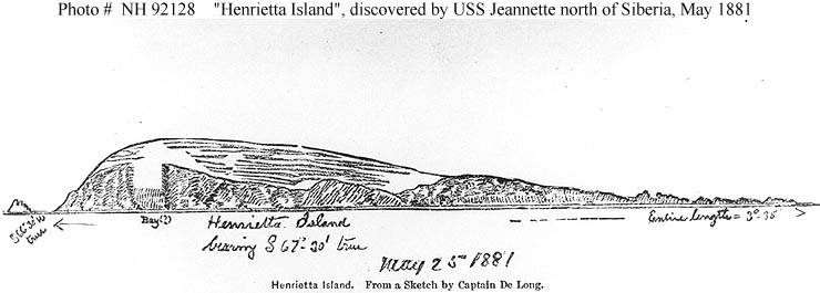
American explorer and US Navy lieutenant commander George W. De Long set out in 1879 aboard the Jeannette, hoping to reach Wrangel Island and to discover open seas in the Arctic Ocean near the North Pole. However, the ship entered an ice pack near Herald Island in September 1879 and became trapped. The vessel drifted several hundred miles with the ice, passing north of Wrangel Island. In May 1881 it approached Jeannette Island and Henrietta Island. According to The Annual Report of the Secretary of the Navy, for the Year 1882 (p. 16), "A sled party landed, hoisted the national ensign, and took possession in the name of the United States". The excursion was led by George W. Melville, accompanied by William Dunbar, William Nindemann, Hans Erichsen, Walter Sharvell and James Bartlett. They landed on June 2 or 3, constructed a cairn, and placed inside it a record of their visit.[6]
During the 1914–1915 Imperial Russian Arctic Ocean Hydrographic Expedition led by Boris Vilkitsky, the Vaygach approached Jeannette Island with the intention of mapping Jeannette and Henrietta Islands, but heavy ice blocked the approach.[7] In 1916 the Russian ambassador in London issued an official notice to the effect that the Imperial government considered Henrietta, along with other Arctic islands, integral parts of the Russian Empire. This territorial claim was later maintained by the Soviet Union.
A Soviet polar station was established on Henrietta Island in 1937 in an expedition by Rudolf Samoylovich, and closed in 1963. Henrietta Island served in 1979 as the starting point for a Soviet expedition to the North Pole on skis.[8]
Some U.S. individuals assert American ownership of Henrietta Island, and others of the De Long group, based on the 1881 discovery and claim. However, according to the U.S. Department of State in 2003, the U.S. government has never claimed Henrietta Island.[9]
Physical description
Henrietta Island was described by the sled party from the De Long expedition in the following terms: "The island is a desolate rock, surmounted by a snow-cap, which feeds several discharging glaciers on its east face. Dovekies nesting in the face of the rock are the only signs of game. A little moss, some grass, and a handful of rock were brought back as trophies. The cliffs are inaccessible, because of their steepness."[10]
 |
 |
References
- Ershova, V.B., Lorenz, H., Prokopiev, A.V., Sobolev, N.N., Khudoley, A.K., Petrov, E.O., Estrada, S., Sergeev, S., Larionov, A. and Thomsen, T.B., 2016. The De Long Islands: A missing link in unraveling the Paleozoic paleogeography of the Arctic. Gondwana Research, 35, pp.305-322.
- Shumskiy, P.A., 1939. A glaciological and geomorphological sketch of Henrietta Island. Izvestiya GGO, 71(9), pp.1352-1365.
- Prokopiev, A.V., Ershova, V.B., Anfinson, O., Stockli, D., Powell, J., Khudoley, A.K., Vasiliev, D.A., Sobolev, N.N. and Petrov, E.O., 2018. Tectonics of the New Siberian Islands archipelago: Structural styles and low-temperature thermochronology. Journal of Geodynamics, 121, pp.155-184.
- Sides, Hampton (2015). In the Kingdom of Ice: The Grand and Terrible Polar Voyage of the USS Jeannette. Oneworld Publications. p. 480.
- Starokadomski, L.M. and O.M. Cattley, 1919, "Vilkitski's North-East Passage, 1914–15". The Geographical Journal. vol. 54, no. 6, pp. 367–375 (December 1919) (requires JSTOR access).
- Adventure Club, nd, 25 лет с Северным полюсом!, a description of the 1979 polar ski trek from the Adventure Club (Russian). Last visited May 26, 2008.
- Bureau of European and Eurasian Affairs, US State Department, 2003, Status of Wrangel and other Arctic islands Last visited May 10, 2009.
- De Long, Emma, ed., 1883, The Voyage of the Jeannette: The Ship and Ice Journals of George W. De Long, Volume II. Houghton Mifflin and Company. Last visited May 26, 2008 at the Internet Archive).
External links
- Anisimov, M.A., and V.E. Tumskoy, 2002, Environmental History of the Novosibirskie Islands for the last 12 ka. 32nd International Arctic Workshop, Program and Abstracts 2002. Institute of Arctic and Alpine Research, University of Colorado at Boulder, pp 23–25.
- Anonymous, 1923, Wrangel Island. The Geographical Journal, Vol. 62, No. 6. pp. 440–444 (Dec., 1923). (requires JSTOR access).
- Headland, R.K., 1994, OSTROVA DE-LONGA ('De Long Islands'). Scott Polar Research Institute, Cambridge University. Lasted visited May 26, 2008.
- Schirrmeister, L., H.-W. Hubberten, V. Rachold, and V.G. Grosse, 2005, Lost world - Late Quaternary environment of periglacial Arctic shelves and coastal lowlands in NE-Siberia. 2nd International Alfred Wegener Symposium Bremerhaven, October, 30 - November 2, 2005.
|
| Authority control |
|
|---|
На других языках
[de] Henrietta-Insel
Die Henrietta-Insel (russisch остров Генриетты) ist die nördlichste der De-Long-Inseln im Archipel der Neusibirischen Inseln. Die unbewohnte Insel liegt im nördlichen Teil der Ostsibirischen See.- [en] Henrietta Island
[fr] Île Henriette
L'Île Henriette (en russe : Генрие́тты) se situe en mer de Sibérie orientale[1] et fait partie des îles De Long, elles-mêmes incluses dans l'archipel de Nouvelle-Sibérie, au nord de la Russie de l'Est. L'île se trouve à 46 kilomètres au nord-ouest de l'île Jeannette et 264 kilomètres au nord-nord-est de l'île Novaya Sibir. Sur le plan administratif elle est rattachée à la République de Sakha (Yakoutie) en Russie.[it] Isola di Henrietta
L'isola di Henrietta (in russo Остров Генриетты, ostrov Genrietty) è una delle isole De Long che fanno parte dell'arcipelago delle isole della Nuova Siberia. Amministrativamente fa parte del Bulunskij ulus del territorio della Repubblica autonoma russa della Sacha-Jacuzia, nel Circondario federale dell'Estremo Oriente, (Siberia orientale).[ru] Остров Генриетты
Остров Генриетты (якут. Хенриетта арыыта) — остров в группе островов Де-Лонга в Восточно-Сибирском море, в северо-восточной части Новосибирских островов. Принадлежит России. Площадь около 12 км², высота — до 315 метров. Административно входит в состав республики Саха (Якутия). Является крайним северным островом Восточно-Сибирского моря.Другой контент может иметь иную лицензию. Перед использованием материалов сайта WikiSort.org внимательно изучите правила лицензирования конкретных элементов наполнения сайта.
WikiSort.org - проект по пересортировке и дополнению контента Википедии