geo.wikisort.org - Island
Mauke (Ma'uke also Akatokamanava) is an island of the Cook Islands archipelago, lying in the central-southern Pacific Ocean. Part of the Nga-pu-Toru, it is 277 km (172 mi) northeast of Rarotonga.
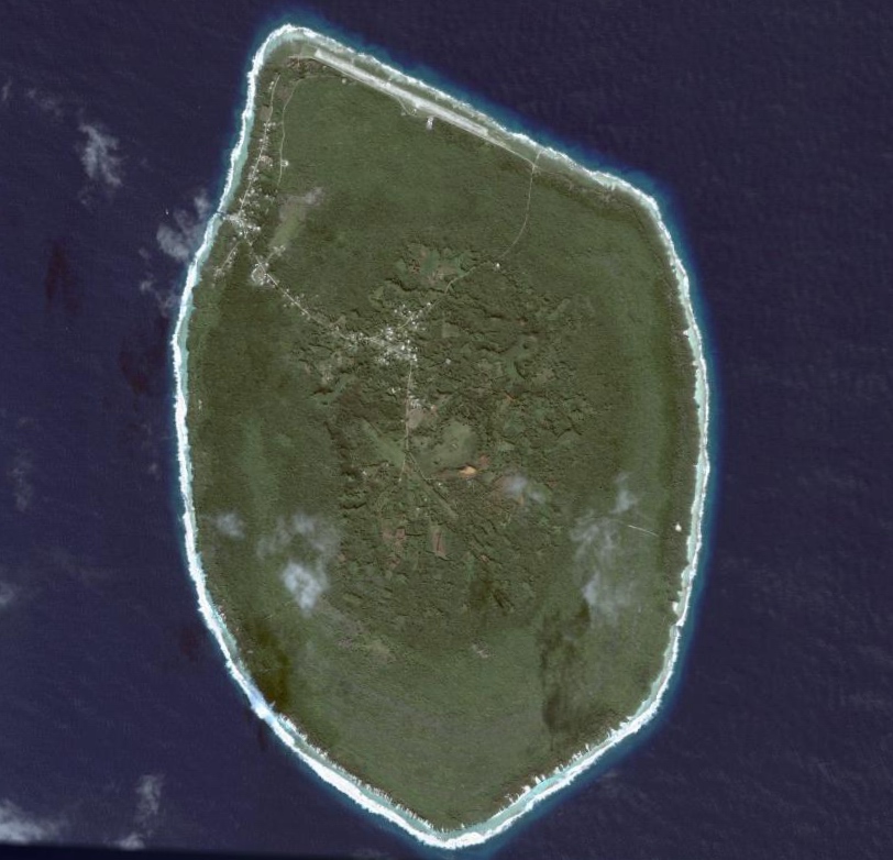 Satellite Image of Mauke | |
| Geography | |
|---|---|
| Location | Central-Southern Pacific Ocean |
| Coordinates | 20.1583°S 157.3417°W |
| Archipelago | Cook Islands |
| Area | 18.4 km2 (7.1 sq mi) |
| Administration | |
Cook Islands | |
| Demographics | |
| Population | 297 (2016)[1] |
| Ethnic groups | Polynesian |


Geography
Mauke is a raised coral atoll, with a central volcanic plateau surrounded by a jagged fossilised coral makatea which extends up to one mile inland.[2] A narrow layer of swamps lies between the makatea and the plateau. The entire island is surrounded by a fringing reef, pierced by six passages, and sits atop an extinct volcano rising 4,500 m (14,800 ft) from the ocean floor.[3]
The volcanic soil in the island's center is relatively fertile, so it is called "The Garden of the Islands".[4] The makatea is honeycombed with caves, including the Vaitango Cave, Moti Cave and Motuanga Cave.[5]
History
According to oral tradition, Mauke was discovered by Uke, and the island was named "Ma'uke" - "the land of Uke" - after him.[3] Uke's descents then went on to settle Atiu. Another legend states a son of Ruatapu was murdered on Mauke, and in retaliation he killed many of the islands inhabitants.[3] The island was dominated by Atiu, who frequently raided it.[3] The next European to sight Mauke was John Williams of the London Missionary Society, in 1823. He left behind a Polynesian preacher, Haavi, to introduce Christianity. The third European visitor was Captain Lord Byron of HMS Blonde in 1825, who named it "Parry Island" in honour of Sir William Edward Parry.[3] In the 1840s an Atiuian expedition attempted to raid the island again, but retreated after hearing that the Maukeans had been supplied with muskets by a European trader. In the 1860s Ngamaru Rongotini Ariki, ariki of Atiu, Mauke and Mitiaro, married Makea Takau Ariki, a Rarotongan ariki. As a result, in 1871 Mauke became part of the Kingdom of Rarotonga.
In 1888 Mauke became a British protectorate as part of the Cook Islands Federation. In 1901 it was annexed by New Zealand.
In 1904, animosity between followers of the London Missionary Society and the newly introduced Roman Catholic church led to the formation of the village of Kimiangatau on Mauke's coast.[3]
Demographics
| Year | Pop. | ±% |
|---|---|---|
| 1906 | 446 | — |
| 1916 | 490 | +9.9% |
| 1926 | 511 | +4.3% |
| 1936 | 652 | +27.6% |
| 1951 | 836 | +28.2% |
| 1961 | 785 | −6.1% |
| 1966 | 671 | −14.5% |
| 1976 | 710 | +5.8% |
| 1986 | 692 | −2.5% |
| 1996 | 652 | −5.8% |
| 2001 | 470 | −27.9% |
| 2006 | 391 | −16.8% |
| 2011 | 307 | −21.5% |
| 2016 | 297 | −3.3% |
| Source:[1] | ||
Mauke has a population of 297 in 2016.[1] At the 2016 census one-third of the population was under 19 years of age, and 24% over 60.[6]
The island is subdivided into four traditional districts.[7] Vaimutu and Makatea are not further subdivided and correspond to one tapere each. Ngatiarua and Areora districts are subdivided into 6 and 3 tapere, respectively, totalling 11 tapere for the whole island: [8][9]
- Ngatiarua District (north, subdivided into 6 tapere: Te Tukunga, Mokoero, Puneua, Ikurua, Arakiropu, Araki)
- Vaimutu District (east, corresponds to 1 tapere)
- Areora District (south, subdivided into 3 tapere: Tukume, Arao, Anua)
- Makatea District (west, corresponds to 1 tapere)
Oiretumu, the principal village, is located inland, mainly within the traditional Makatea district. Stretching north from Taunganui Landing, the commonly used western landing is the village of Kimiangatau, mainly within Ikurua tapere of Ngatiarua District.[10]
Economy
Mauke's economy is primarily government-supported, with 61% of the labour force employed in the public sector.[6] Its primary export is maire, a plant which is used to make leis. There is little tourism, with only two budget accommodation providers on the island.[6]
Mauke is connected to the rest of the Cook Islands by Mauke Airport. The island's main harbour was damaged by cyclones in 2005. An upgrade began in 2011,[11] and was completed in 2013.[12]
Previously powered by diesel generators, since 2019 it has been powered by a 229 kW solar-diesel power station.[13]
References
- "Cook Islands 2016 Census Main Report" (PDF). Cook Islands Statistical Office. 2018. p. 46. Retrieved 19 August 2020.
- B. L. Wood (1967). "Geology of the Cook Islands". New Zealand Journal of Geology and Geophysics. 10 (6): 1438–1439. doi:10.1080/00288306.1967.10423227. Retrieved 22 August 2020.
- Kloosterman, Alphons M. J. (1976). "Discoverers Of The Cook Islands And The Names They Gave". Cook Islands Library and Museum. pp. 24–26. Retrieved 22 August 2020 – via NZETC.
- Derek Fox (1 April 2018). "Emotional 'homecoming'". Gisborne Herald. Retrieved 22 August 2020.
The volcanic origin means that the soil is rich and this is justifiably called the garden of the islands.
- "Mauke". Cook Islands Tourism Corporation. Retrieved 22 August 2020.
- "Island Profile: Mauke" (PDF). Ministry of Finance and Economic Management. Retrieved 27 August 2020.
- "Mauke: Garden of the Islands". Cook Islands. Retrieved 26 October 2013.
- "The Island of Mauke Map". Archived from the original on 2012-07-30. Retrieved 2019-07-20.
- "Oc_mauke". Archived from the original on July 9, 2007. Retrieved May 1, 2009.
- Naval Intelligence Division: Pacific Islands. Volume II: Eastern Pacific, 1943, p. 545
- "Upgrade begins on Mauke Harbour". Cook Islands News. 14 June 2011. Retrieved 27 August 2020.
- "Mitiaro and Mauke celebrate revamped ports". Cook Islands News. 30 May 2013. Retrieved 27 August 2020.
- "Mauke switches to solar energy". Cook Islands News. 3 July 2019. Retrieved 27 August 2020.
External links
Cook Islands | ||
|---|---|---|
| Northern chain | ||
| Southern chain - Nga-pu-Toru | ||
| Southern chain - other | ||
| Authority control |
|
|---|
На других языках
[de] Mauke (Insel)
Mauke (veraltet Akatokamanava oder Parry's Island) gehört der südlichen Inselgruppe der Cookinseln an.- [en] Mauke
[es] Mauke
Mauke es una de las Islas Cook, archipiélago libre en el Océano Pacífico asociado a Nueva Zelanda. Posee una población de 300 habitantes.[1][fr] Mauke
Mauke, appelé également Akatokamanava, est un atoll surélevé[1] des Îles Cook situé à 44 km au sud-est de Mitiaro et à 273 km à l'est-nord-est de Rarotonga. L'atoll représente une superficie d'environ 20 km². Sa formation géologique est identique à celle des îles de Mitiaro et d'Atiu avec lesquelles, elle forme un sous ensemble insulaire: les Ngaputoru. La population composée de 650 personnes (recensement 2004), se concentre dans les deux villages adjacents de Ngatiarua et Areroa.[it] Mauke
Mauke è un'isola appartenente all'arcipelago delle Isole Cook, localizzato 76 km a sud-est di Atiu.[ru] Мауке
Мауке (англ. Mauke) — остров, поднятый атолл в Тихом океане в составе южной группы островов Кука (самый восточный). Вместе с соседними островами Митиаро и Атиу (а также необитаемым островом Такутеа) именуется общим названием Нгапутору («три корня»[1] или «три острова вместе»[2]).Другой контент может иметь иную лицензию. Перед использованием материалов сайта WikiSort.org внимательно изучите правила лицензирования конкретных элементов наполнения сайта.
WikiSort.org - проект по пересортировке и дополнению контента Википедии