geo.wikisort.org - Island
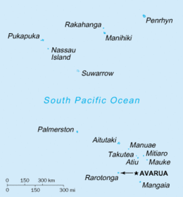
Manuae is an uninhabited atoll in the southern group of the Cook Islands, 100 kilometres south-east of Aitutaki. It is administratively part of Aitutaki, but it does not belong to any district or tapere of Aitutaki. It is, however, part of Arutanga-Reureu-Nikaupara Constituency.
 An aerial view of Manuae | |
 | |
| Geography | |
|---|---|
| Area | 6.17 km2 (2.38 sq mi) |
| Highest elevation | 5 m (16 ft) |
| Administration | |
Cook Islands | |
| Demographics | |
| Population | 0 (2006) |
Geographic description
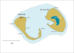
Manuae is a true atoll sitting on the peak of a submerged volcano which descends over 4000 meters to the ocean bed. It comprises two horseshoe-shaped islets, Manuae to the west and Te Au O Tu to the east, with a total area of 6 km2[1] on either side of a lagoon about 7 km x 4 km. Manuae has an area of 2.1 km2, while Te Au O Tu's is 3.9 km2.[2] The lagoon is 13 km2 in size, shallow and subject to large shifting sand banks.[3] A coral reef surrounds the atoll, and there is no passage through the reef.[4]
The island is a marine park and is an important breeding ground for seabirds and marine turtles in the Central Pacific. The offshore waters of Manuae are good fishing grounds.
History
According to oral tradition, Manuae was discovered by Ruatapu, who named it Manu-enua ("bird-land").[1] Ruatapu planted coconuts and released birds there, and later sent his second son and his family to settle the island. Another tradition states that the island was first settled by two brothers from Atiu, and that Ruatapu found it already inhabited.[1] Later the island was attacked by Mangaia.[1]
Captain James Cook sighted Manuae on his second voyage on 23 September 1773, but did not land.[1] He visited again on 6 April 1777 during his third voyage, and found the island inhabited and apparently under the control of an ariki from Atiu.[1] Cook initially named Manuae "Sandwich Island", but changed it to "Hervey Island" in honor of Augustus Hervey, 3rd Earl of Bristol, then a Lord of the Admiralty. This name was later corrupted to Hervey's Island, or Hervey's Isle, and later applied to the entire southern group, as the Hervey Islands.[5]: 92
In July 1823 the island was visited by John Williams of the London Missionary Society, who found it inhabited by sixty people.[1] The island was depopulated shortly afterwards, and by 1852 was home to a single family.[1] In 1888 it was declared to be a British protectorate.[6] In 1900 it was annexed by New Zealand.[7] At this stage the island was controlled by Aitutaki, who in 1898 leased it out as a copra plantation.[8]
In April/May 1965 the population briefly increased to more than a hundred when the island was visited by six expeditions (from Australia, N.Z., Japan, U.K., U.S.A. and U.S.S.R.) to observe the total solar eclipse of 30 May 1965.[9]
Norwegian author Erlend Loe writes humorously about an expedition to Manuae in his 1999 novel "L".
In April 2020 the Cook Islands National Environment Service advertised for two caretakers to live on the island for a year.[10]
Economy and improvements
The island once supported a small copra industry with a settlement established next to the small reef passage less than one kilometer northeast of Turakino, the westernmost point of the atoll. The passage, at the sea entrance, is less than 4 metres wide and in a swell is exceedingly dangerous without local knowledge.
The island has an airfield (a dirt airstrip barely visible) that has been out of use for several years. Fishermen from Aitutaki occasionally organise trips to Manuae. All regulations applicable to Aitutaki, apply to Manuae as well.[3]
Demography
The population peaked with 32 at the 1956 census, but twenty years later the island was abandoned.
|
| |||||||||||||||||||||||||||
| Papers Past[11] | ||||||||||||||||||||||||||||
See also
- Desert island
- Lists of islands
References
- Alphons M.J. Kloosterman (1976). Discoverers of the Cook Islands and the Names they Gave. Cook Islands Library and Museum. p. 21. Retrieved 29 July 2020.
- A. H. McLintock, ed. (1966). "ISLAND TERRITORIES: COOK ISLANDS". Retrieved 29 July 2020 – via Te Ara - the Encyclopedia of New Zealand.
- "Basic Information on the Marine Resources of the Cook Islands" (PDF). Ministry of Marine Resources. p. 37. Retrieved 22 January 2022.
- "SECTOR 2: THE LINE ISLANDS, THE COOK ISLANDS, THE SAMOA ISLANDS, AND THE TONGA ISLANDS (INCLUDING OFF-LYING ISLANDS AND REEFS)". Sailing Directions (enroute) for the Pacific Islands (PDF). Defense Mapping Agency, Hydrographic/Topographic Center. 2002. p. 50. Archived (PDF) from the original on 25 October 2004.
- te Rangi Hiroa (1945). An Introduction to Polynesian Anthropology. Honolulu: Bernice P. Bishop Museum. Retrieved 18 November 2021 – via NZETC.
- "The Cook Group". Ashburton Guardian. 15 October 1888. p. 2. Retrieved 18 November 2021 – via Papers Past.
- "PACIFIC ISLANDS ANNEXATION". Otago Witness. 10 October 1900. p. 11. Retrieved 18 November 2021 – via Papers Past.
- "SOLAR ECLIPSE WILL PUT TINY MANUAE ON THE MAP". Pacific Islands Monthly. Vol. 35, no. 2. 1 February 1964. p. 85. Retrieved 18 November 2021 – via National Library of Australia.
- "'Black Disappointment' For Island Eclipse Watchers". Pacific Islands Monthly. Vol. 36, no. 7. 1 July 1965. p. 71-72. Retrieved 18 November 2021 – via National Library of Australia.
- "'Best job in world' advertised in Cook Islands". RNZ. 7 April 2020. Retrieved 29 July 2020.
- "COOK ISLANDS - Lower Group Census". Evening Post. 28 May 1936. p. 10. Retrieved 29 July 2020 – via National Library of New Zealand.
External links
Cook Islands | ||
|---|---|---|
| Northern chain | ||
| Southern chain - Nga-pu-Toru | ||
| Southern chain - other | ||
| Authority control |
|
|---|
На других языках
[de] Manuae (Cookinseln)
Manuae ist ein etwa 28 km² großes Atoll in der Südgruppe der Cookinseln; es liegt 300 km nordöstlich der Hauptinsel Rarotonga.- [en] Manuae (Cook Islands)
[es] Manuae (Islas Cook)
Manuae es un atolón inhabitado del grupo meridional de las Islas Cook. Se encuentra a 100 kilómetros al sureste de Aitutaki. Se compone de dos islotes, Manuae y Te Au O Tu con un área total de 6 kilómetros cuadrados. Están en lugares contrapuestos en los bordes de la laguna interior, cuya extensión es de 7 kilómetros de largo por 4 de ancho. La mayor altitud es 5 metros sobre el nivel del mar. El atolón de Manuae se encuentra sobre el pico de un volcán submarino que se eleva 4000 metros sobre la plataforma marina.[fr] Manuae (îles Cook)
Manuae est un atoll présentant deux motu : Ta Au O Tu à l'est et Manuae à l'ouest. Situé à 229 kilomètres au Nord de Rarotonga et 110 à l'Est d'Aitutaki, sa superficie totale est de 6 km2 (2,1 km2 pour Manuae et 3,9 km2 pour Te Au O Tu).[it] Manuae (Isole Cook)
Manuae è un atollo composto da due isole appartenente all'arcipelago delle Isole Cook, localizzato 100 km a sud-est di Aitutaki.[ru] Мануаэ (острова Кука)
Мануаэ (англ. Manuae) — остров в Тихом океане, в составе Южной группы островов Кука.Другой контент может иметь иную лицензию. Перед использованием материалов сайта WikiSort.org внимательно изучите правила лицензирования конкретных элементов наполнения сайта.
WikiSort.org - проект по пересортировке и дополнению контента Википедии