geo.wikisort.org - Island
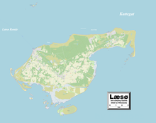
Læsø ("Isle of Hlér") is the largest island in the North Sea bay of Kattegat, and is located 19 kilometres (12 mi) off the northeast coast of the Jutland Peninsula, the Danish mainland. Læsø is also the name of the municipality (Danish, kommune) on that island. The island is a location mentioned in several instances in Old Norse sources detailing Norse mythology.
This article uses bare URLs, which are uninformative and vulnerable to link rot. (August 2022) |
 Højsande, Læsø | |
 | |
| Geography | |
|---|---|
| Location | Kattegat |
| Coordinates | 57°15′36″N 11°00′00″E |
| Area | 101 km2 (39 sq mi) |
| Administration | |
Denmark | |
| Region | North Jutland Region |
| Municipality | Læsø Municipality |
| Largest settlement | Byrum (pop. 488) |
| Demographics | |
| Population | 1,793 (2017) |
| Pop. density | 15.74/km2 (40.77/sq mi) |
Ramsar Wetland | |
| Official name | Læso |
| Designated | 2 September 1977 |
| Reference no. | 149[1] |
Name and Norse mythology
The modern Danish form of the island's name, læsø, developed from Old Norse Hlésey, meaning 'Hlér's island'.[2] Hlér (Old Norse 'sea'), also known as Ægir (also Old Norse 'sea'), is a jötunn and personification of the sea in Norse mythology whose nine daughters personify waves. Similarly, the Danish city of Lejre may also derive from Hlér.[3]
In the Poetic Edda poem Hárbarðsljóð, the god Thor comments that it was on Hlésey that he was attacked by (and so fought) "berserk women" or "brides of berserks" who had bewitched all of the men on the island. Thor details that, upon beaching his ship, the women battered it, threatened him with iron clubs and chased his servant, Þjálfi:
- Benjamin Thorpe translation:
- She-wolves they were, and scarcely women.
- They crushed my ship, which with props I had secured,
- with iron clubs threatened me, and drove away Thiâlfi.
- What meanwhile didst thou, Harbard?[4]
- Henry Adams Bellows translation:
- She-wolves they were like, and women little;
- My ship, which well I had trimmed, did they shake;
- With clubs of iron they threatened, and Thjalfi they drove off.
- What, Harbarth, didst thou the while?[5]
These "women" are personified waves and/or jötnar. The island is also a setting in the poems Helgakviða Hundingsbana II and Oddrúnargrátr, the saga Örvar-Odds saga, in two skaldic kennings, and the aforementioned (see etymology section above) Prose Edda book Skáldskaparmál.[6]
The Municipality of Læsø
The municipality is in Region Nordjylland in northern Denmark. The municipality, Denmark's least populous, covers Læsø and neighboring small islands for a total area of 114 square kilometres (44 sq mi), and has a total population of 1,793 as of 1 January 2017.[7][8] The population has been steadily declining, and according to Danmarks Statistik (Statistikbanken.dk) was:
| Year | Inhabitants |
|---|---|
| 2006 | 2091 |
| 2007 | 2056 |
| 2008 | 2003 |
| 2009 | 1993 |
| 2010 | 1969 |
| 2011 | 1949 |
| 2012 | 1897 |
| 2013 | 1839 |
| 2014 | 1808 |
| 2015 | 1795 |
| 2016 | 1817 |
| 2017 | 1793 |
Its mayor is Karsten Nielsen as of 2021. He is a member of the Venstre political party.
The main town and the site of its municipal council is Byrum.
Because Læsø is an island and lies in the Kattegat, its neighboring municipality, Frederikshavn on the Jutland peninsula, is separated by water, the Læsø Rende, from the island municipality.
Ferry service connects Frederikshavn on the Jutland peninsula to the municipality at the town of Vesterø Havn while Østerby Havn is the island's fishing harbour.
Læsø Municipality was not merged with any adjacent municipality under the municipal reform of 2007, as it agreed to enter into a "municipal cooperation agreement" with Frederikshavn Municipality.[9]
Municipal council
Læsø's municipal council consists of 9 members, elected every four years.
Below are the municipal councils elected since the Municipal Reform of 2007.
| Election | Party | Total seats |
Turnout | Elected mayor | |||||||||
|---|---|---|---|---|---|---|---|---|---|---|---|---|---|
| A | D | F | H | L | O | V | |||||||
| 2005 | 2 | 2 | 2 | 3 | 9 | 78.5% | Olav Juul Gaarn Larsen (V) | ||||||
| 2009 | 2 | 1 | 1 | 4 | 2 | 81.8% | Thomas W. Olsen (L) | ||||||
| 2013 | 2 | 1 | 1 | 2 | 1 | 2 | 83.7% | Tobias B. Johansen (L) | |||||
| 2017 | 1 | 2 | 2 | 4 | 82.3% | Karsten Nielsen (O) | |||||||
| Data from Kmdvalg.dk 2005, 2009, 2013 and 2017 | |||||||||||||
Nature and protections
Læsø has an outstanding botanical interest. The nature-types on and around Læsø includes open water, extensive mudflats, sand banks, heathland, islets and areas of arable land. It houses Denmark's largest tidal saltmarsh outside the Wadden Sea but the decline in grazing animals has led to a gradual vegetational succession. Invasive species are colonizing the site, especially Japanese Rose, and scrub clearance has been implemented to re-establish the former pastures open heathland. Seals like the Harbor seal are breeding around Læsø and the whole area is an internationally important area for wintering, molting and staging waterbirds. Therefore, a Ramsar protection was put into force in 1977 (number 149) and today it encompass 66,548 ha.[10]

Climate, industry, and wildlife
Together with Anholt, Læsø belongs to the Danish "desert belt"; during the summer months there is so little rain that streams and ponds partly dry up.
In the Middle Ages, the island was known for its salt industry. The ground water can reach over 15 percent salt, and this was naturally concentrated in flat salt meadows during the hot dry summers. The final concentration, carried out in hundreds of salt kilns, consumed large amounts of wood. Eventually the island became deforested, sandstorms buried villages, and salt extraction was banned. Since the end of the 1980s it has been resumed on a small scale as an archaeological experiment and a tourist attraction.
Læsø is home to unique styles of Danish traditional music. Most of it is not played any more but has been preserved through intense documentation and research in the 1980s and 1990s.
The HVDC powerline Kontiskan crosses Læsø as overhead line. On Læsø, there is also a 160 metres tall radio relay mast.

In 1993 a conservation area was established for the A. m. mellifera nicknamed the Brown Bee of Læsø, where it became illegal according to Danish Law to keep and import any other type of bee other than Apis mellifera mellifera, this was met with protests and a legal battle lasting eight years from other beekeepers of A. m. ligustica, A. m. carnica and Buckfast bees as they did not "want to become a custodian of poor bees", they also stated that A. m. mellifera was "unproductive" and "not worthy of protection". They lost their case in 2001,[11] and negotiations between A. m. mellifera beekeepers and non-A. m. mellifera beekeepers were concluded in 2004, splitting the island in two between them, ending a "history of sabotage of bees" on the island.[12] The A. m. mellifera supporters claimed that they had "introduced apartheid on Læsø for the bees".[13]
Notable residents
- Gustav S. Christensen (1929 in Læsø – 2007 in Canada) an academic mathematician and engineer.
- Mogens Bay Esbensen (born 1930) a prominent Danish born chef and author has lived there since 1992 [14]
- Per Kirkeby (1938–2018) a Danish painter, poet, film maker and sculptor owned a house and studio on the island
Gallery
 Læsø kur
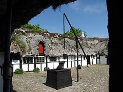 Museumsgården
 Læsø
Læsø Fannemandsfærgen


See also
- Johns Rock
- List of islands of Denmark
Notes
- "Læso". Ramsar Sites Information Service. Retrieved 25 April 2018.
- McKinnell (2005:110) and Faulkes (1995:59).
- Simek 1996, p. 151.
- Thorpe (1866:76).
- Bellows (1923:92).
- McKinell (2005:110).
- "Læsø Kommune", Den store Danske. (in Danish) Retrieved 28 June 2010.
- "Danmarks Statistik." Retrieved 11 February 2015.
- https://www.retsinformation.dk/Forms/R0710.aspx?id=10080
- The Annotated Ramsar List: Denmark Archived 2014-02-22 at the Wayback Machine Ramsar, 05.08.2013
- "Re: Criminal proceedings against Ditlev Bluhme" (PDF). biicl.org. Court of Justice of the European Communities. Retrieved 22 January 2019.
- Kryger, Per. "SNHBS Annual Meeting - Diversity in European Honey Bees". snhbs.scot. SNHBS. Retrieved 22 January 2019.
- Kryger, Per. "Diversity in European honey bees - How to conserve it?" (PDF). snhbs.scot. SNHBS. Retrieved 22 January 2019.
- "HugeDomains.com - StephenDownes.com is for sale (Stephen Downes)". stephendownes.com. Retrieved 12 April 2018.
{{cite web}}: Cite uses generic title (help)
References
- Bellows, Henry Adams (Trans.) (1923). The Poetic Edda. New York: The American-Scandinavian Foundation.
- Faulkes, Anthony (Trans.) (1995). Edda. Everyman. ISBN 0-460-87616-3
- McKinnell, John (2005). Meeting the Other in Norse Myth in Legends. D.S. Brewer. ISBN 1-84384-042-1
- Simek, Rudolf (1996). Dictionary of Northern Mythology. D.S. Brewer. ISBN 978-0-85991-513-7.
- Thorpe, Benjamin (Trans.) (1907). The Elder Edda of Saemund Sigfusson. Norrœna Society.
External links
- Official website
- Municipal statistics: NetBorger Kommunefakta, delivered from KMD aka Kommunedata (Municipal Data)
- Municipal mergers and neighbors: Eniro new municipalities map
Places adjacent to Læsø | ||||||||||||||||
|---|---|---|---|---|---|---|---|---|---|---|---|---|---|---|---|---|
| ||||||||||||||||
Islands of Denmark
| ||
|---|---|---|
| Baltic Sea | ||
| Sydhavsøerne | ||
| Kattegat | ||
| South Funen Archipelago |
| |
| Limfjorden | ||
| Øresund | ||
| Great Belt | ||
| Little Belt | ||
| Wadden Sea | ||
| Other islands | ||
Municipalities of Denmark | ||
|---|---|---|
List | ||
| Hovedstaden | 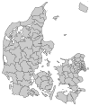 | |
| Midtjylland | ||
| Nordjylland | ||
| Sjælland | ||
| Syddanmark | ||
На других языках
[de] Læsø
Læsø anhören?/i (auch Laesoe oder Vor Frue Land) ist eine dänische Insel im nördlichen Kattegat. Als Gesamtgemeinde hat sie 1769 Einwohner (1. Januar 2022.[1]) Die etwa 101 km² große Insel[2] (1916 waren es noch 116,4 km²[3]) ist die am dünnsten besiedelte Gemeinde Dänemarks. Ursprünglich bildete Læsø eine eigene Harde im Hjørring Amt, bestehend aus den Kirchspielen Byrum Sogn (43,89 km², Hauptort Byrum, 444 Einwohner), Hals Sogn (24,55 km², Hauptort Østerby Havn, 269 Einwohner) und Vesterø Sogn (48,06 km², Hauptort Vesterø Havn, 340 Einwohner).(Einwohnerzahlen: 1. Januar 2022)[4][5] Ab 1970 bildete die Insel eine eigene Kommune Læsø Kommune im Nordjyllands Amt, die im Zuge der Kommunalreform zum 1. Januar 2007 unangetastet blieb und nun als kleinste Kommune Dänemarks zur Region Nordjylland gehört.- [en] Læsø
[fr] Læsø
Læsø est une île ainsi que la commune du Danemark qui en épouse le territoire. L’île, d’une superficie de 118 km2, se situe en mer du Nord dans le détroit du Cattégat, et hébergeait 1 806 habitants en 2019.[it] Læsø (isola)
Læsø è un'isola nel mar Baltico, nello stretto del Kattegat, appartenente alla Danimarca.[ru] Лесё
Лесё (дат. Læsø) — крупнейший остров в проливе Каттегат. Площадь 101,22 км², население — 1993 человек (2009). Отделён от полуострова Ютландия проливом Лесё-Ренне (дат. Læsø Rende) шириной 19 км.Другой контент может иметь иную лицензию. Перед использованием материалов сайта WikiSort.org внимательно изучите правила лицензирования конкретных элементов наполнения сайта.
WikiSort.org - проект по пересортировке и дополнению контента Википедии