geo.wikisort.org - Island
Helnæs is an island on the southwestern coast of Funen, Denmark, southwest of Haarby and northwest of Faaborg. It belongs administratively to Assens Municipality and is connected to the town of Assens by road to the north.

Geography
Between Helnæs and the main island of Funen is Helnæs Bay, which contains the sprawling islands of Illumø, Horsehoved and Vigø to the southeast.[1] The principal settlement of Helnæs lies on the southeast coast, and contains the camping site Helnæs Camping to the north of it, although the historical village of Helnæs By is further to the north, inland. The highest point of the island is Galgebakke, at 29 feet (8.8 m).[2]
Landmarks
There is a runestone on the island, known as the Helnæs Runestone[citation needed]. The 28 metres (92 ft) high Helnæs Lighthouse was completed in 1901.[2][3]
 Helnæs Church
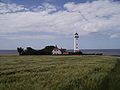 Helnæs Lighthouse
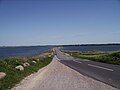 Road from the mainland


References
- Google (8 July 2014). "Helnæs" (Map). Google Maps. Google. Retrieved 8 July 2014.
- "Seværdigheder" (in Danish). The Danish Nature Agency, Danish Ministry of the Environment. Retrieved 8 July 2014.
- "Helnæs Fyr" (in Danish). Fyrtaarne.dk. Retrieved 8 July 2014.
This article about an island of Denmark is a stub. You can help Wikipedia by expanding it. |
На других языках
[de] Helnæs
Helnæs ist eine Halbinsel in Dänemark an der Westseite der Insel Fünen im Kleinen Belt, die durch einen 2,8 km langen, schmalen Damm[1], den Langøre, mit Agernæs und Westfünen verbunden ist. Helnæs liegt an der Westküste etwa 20 km südlich der Stadt Assens und ist Teil der Kommune Assens.- [en] Helnæs
Другой контент может иметь иную лицензию. Перед использованием материалов сайта WikiSort.org внимательно изучите правила лицензирования конкретных элементов наполнения сайта.
WikiSort.org - проект по пересортировке и дополнению контента Википедии