geo.wikisort.org - Island
Grímsey (Icelandic pronunciation: [ˈkrimsˌeiː]) is a small Icelandic island, 40 kilometres (20 nautical miles) off the north coast of the main island of Iceland, straddling the Arctic Circle. In January 2018 Grímsey had 61 inhabitants.[1]
Grímsey | |
|---|---|
Island | |
 Grímsey Church in June 2008 | |
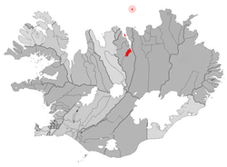 Location of the Municipality of Akureyri | |
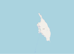 The island Grímsey | |
 Grímsey Location of the island Grímsey | |
| Coordinates: 66°33′N 18°00′W | |
| Country | Iceland |
| Constituency | Northeast Constituency |
| Region | Northeastern Region |
| Municipality | Akureyri |
| Area | |
| • Total | 5.3 km2 (2.0 sq mi) |
| • Land | 5.3 km2 (2.0 sq mi) |
| Elevation | 105 m (344 ft) |
| Population (2018) | |
| • Total | 61 |
| Time zone | WET |
| Website | Official website |


Before 2009, Grimsey constituted the hreppur (municipality) of Grímseyjarhreppur [ˈkrimsˌeiːjar̥ˌr̥ɛhpʏr̥]. In that year, island residents voted to join the municipality with Akureyri.[2] The island's only settlement is Sandvík.[3] [ˈsantˌviːk]
Geography
Grímsey is the northernmost inhabited Icelandic territory; the rapidly disappearing islet of Kolbeinsey lies some 60 km (30 nmi) farther north, but is uninhabitable. The closest land is the island of Flatey, Skjálfandi, 39.4 km (21+1⁄4 nmi) to the south.
The Arctic Circle currently runs through the island, a feature of interest to many visitors, while the entirety of mainland Iceland lies south of the Arctic Circle. Due to long-term oscillations in the Earth's axis, the Arctic Circle currently shifts northward by about 14.5 metres (48 ft) per year, though varying substantially from year to year due to the complexity of the movement. The true position of the Arctic Circle in the early 21st century is already close to the northern tip of the island, and by about the middle of the 21st century, it will no longer cross Grimsey at all. Originally a fixed monument to the Arctic Circle was placed at a conventional location. In 2017 a new monument, comprising an eight-tonne stone sphere, was placed close to the true current location of the circle, in response to its continual movement.[4] Also, through the centuries three markers have been placed and marked with the calculated location: 1717, 1817, and 1917.[5]
There are steep cliffs everywhere except on the southern shoreline. Grímsey has an area of 5.3 square kilometres (2+1⁄16 sq mi), and a maximum elevation of 105 metres (344 ft).[6]
Climate
Despite the northerly latitude, the climate is generally mild because of the North Atlantic Current, which brings warm water from the Gulf of Mexico. The maximum daily mean temperature in any month falls short of 10 °C, so it is within a tundra (ET) climate. The record high temperature of Brú is 22.2 °C (72.0 °F) registered on July 25, 1955.[7]
| Climate data for Grímsey (1981-2010 normals) | |||||||||||||
|---|---|---|---|---|---|---|---|---|---|---|---|---|---|
| Month | Jan | Feb | Mar | Apr | May | Jun | Jul | Aug | Sep | Oct | Nov | Dec | Year |
| Record high °C (°F) | 10.6 (51.1) |
11.0 (51.8) |
13.0 (55.4) |
15.7 (60.3) |
18.4 (65.1) |
18.9 (66.0) |
22.2 (72.0) |
19.3 (66.7) |
20.8 (69.4) |
14.3 (57.7) |
12.8 (55.0) |
18.0 (64.4) |
19.3 (66.7) |
| Average high °C (°F) | 2.1 (35.8) |
1.2 (34.2) |
1.2 (34.2) |
2.4 (36.3) |
6.0 (42.8) |
8.8 (47.8) |
10.8 (51.4) |
11.0 (51.8) |
8.6 (47.5) |
5.1 (41.2) |
3.5 (38.3) |
2.6 (36.7) |
5.3 (41.5) |
| Daily mean °C (°F) | 0.0 (32.0) |
−1.0 (30.2) |
−0.9 (30.4) |
0.5 (32.9) |
3.8 (38.8) |
6.5 (43.7) |
8.6 (47.5) |
8.9 (48.0) |
6.6 (43.9) |
3.3 (37.9) |
1.6 (34.9) |
0.4 (32.7) |
3.2 (37.7) |
| Average low °C (°F) | −2.1 (28.2) |
−3.2 (26.2) |
−2.9 (26.8) |
−1.4 (29.5) |
1.5 (34.7) |
4.2 (39.6) |
6.4 (43.5) |
6.7 (44.1) |
4.5 (40.1) |
1.5 (34.7) |
−0.3 (31.5) |
−1.8 (28.8) |
1.1 (34.0) |
| Record low °C (°F) | −15.6 (3.9) |
−14.6 (5.7) |
−17.2 (1.0) |
−15.0 (5.0) |
−8.9 (16.0) |
−2.8 (27.0) |
0.7 (33.3) |
−3.9 (25.0) |
−3.1 (26.4) |
−6.8 (19.8) |
−12.2 (10.0) |
−12.3 (9.9) |
−17.2 (1.0) |
| Average precipitation mm (inches) | 26.5 (1.04) |
41.5 (1.63) |
31.3 (1.23) |
23.8 (0.94) |
11.4 (0.45) |
10.0 (0.39) |
27.8 (1.09) |
31.5 (1.24) |
35.8 (1.41) |
30.3 (1.19) |
28.9 (1.14) |
24.5 (0.96) |
323.3 (12.71) |
| Average precipitation days | 18.0 | 24.0 | 17.3 | 20.8 | 11.7 | 10.5 | 15.7 | 14.7 | 20.0 | 22.0 | 21.0 | 20.0 | 215.7 |
| Source: Météo Climat (averages)[8][7] | |||||||||||||
Biodiversity
Though treeless, the island's vegetation cover is rich, consisting of marshland, grass, and moss, and the island is home to many birds, especially auks.[9][10] Gulls and arctic terns also inhabit the island.[11] The island has been designated an Important Bird Area (IBA) by BirdLife International because it supports large seabird breeding colonies of black-legged kittiwakes, Atlantic puffins, razorbills and common murres.[12]
Economy and society
The principal industrial activity is commercial fishing. Agriculture and collecting seabird eggs are also common.[10] Grímsey is a popular tourist destination for visitors seeking an Arctic Circle experience. The island is served by regular ferry and aircraft passenger services from the mainland; there is a 3,400' north–south runway on the west side of the island.[3][13]
The island has acquired a reputation for being a bastion of chess-playing.[14] On learning this, the American scholar and keen chess player Willard Fiske took an interest in Grímsey in the 1870s, sending supplies, supporting the economy and leaving money in his will, though he never visited the island.[15]
Infrastructure
The island has a community center, a shop, a library, a public indoor swimming pool and a school from kindergarten to Grade 8. Beyond this age, students travel to Akureyri for further education. The church was formerly a parsonage, and is situated at a place marked as Miðgarður on most maps of the island; however, the single settlement is officially known as Sandvík. Grímsey has two small hotels and a campsite.
Sights
The most famous sight is the Monument to the Arctic Circle in the northern part of the island. Many visitors enjoy observing the rich birdlife on the island. The Protestant Church on Grímsey was built from driftwood in 1867 and renovated in 1956.[16] The nave was 7.69 metres in length and 4.77 metres broad.[17] The choir and the tower were added in 1932. The church was part of the Akureyri parish. There were four services per year. The church was completely destroyed in a fire, on the eve of September 22, 2021.[18]
Transport
The island is served by Grímsey Airport. There are regular flights to Akureyri. A ferry connects the island three days a week with Dalvík on the mainland.
See also
- List of extreme points of Iceland
References
- STATISTICS ICELAND: Population by locality, age and sex 1 January 2011–2018, Px.hagstofa.is, accessed 18 January 2019
- "Grímsey og Akureyri sameinast"., Morgunblaðið 26 April 2009 (in Icelandic)
- Swaney, Deanna (1997). Iceland, Greenland & the Faroe Islands (3rd ed.). Lonely Planet. pp. 251–252. ISBN 0-86442-453-1.
- "Eight-Tonne Sphere Marks Arctic Circle on Grímsey". Iceland Review. 26 September 2017. Retrieved 28 September 2017.
- "Arctic Circle Marker". Atlas Obscura. Retrieved 16 June 2019.
- "Um Grímsey". Grímseyjarhreppur. Retrieved 28 October 2008. (in Icelandic)
- "Météo climat stats for Grímsey (records)". Météo Climat. Retrieved 11 November 2019.
- "Météo climat stats for Islande". Météo Climat. Retrieved 11 November 2019.
- Riley, Laura & William (2005). Nature's Strongholds: The World's Great Wildlife Reserves. Princeton University Press. p. 384. ISBN 978-0-691-12219-9.
- "Important Bird Areas/Grimsey". BirdLife International. 2015. accessed 1 Marcy 2015.
- John Schwartz, Why Are Puffins Vanishing? The Hunt for Clues Goes Deep (Into Their Burrows), New York Times (29 August 2018).
- "Grímsey, Eyjafirdi". BirdLife Data Zone. BirdLife International. 2021. Retrieved 25 November 2021.
- "Grímsey · Iceland". Google.com. Retrieved 24 December 2021.
- Tomasson, Richard F. (1980). Iceland, the First New Society. University of Minnesota Press. p. 50. ISBN 978-0-8166-0913-0.
Grimsey chess.
- Millman, Lawrence; Theroux, Paul (2001). Last Places: A Journey in the North. Houghton Mifflin Books. pp. 109–110. ISBN 978-0-618-08248-3.
- "Um Grímsey - Grímsey". Wayback.vefsafn.is. Archived from the original on 2 May 2007. Retrieved 24 December 2021.
- "Miðgarðakirkja". Archived from the original on 2017-04-16. Retrieved 2021-03-27.
- "Grímsey church destroyed by fire". Ruv.is. 22 September 2021. Retrieved 24 December 2021.
Sources
- Places along the way...Grímsey, published by Bókaútgafan að Hofi
Further reading
- Jack, Robert, Arctic Living: the Story of Grimsey, [with] foreword by Vilhjalmur Stefansson, Toronto, Ont.: Ryerson Press, 1955.
External links
| Authority control |
|
|---|
На других языках
[de] Grímsey
Grímsey ist eine kleine Insel 40 Kilometer nördlich der Nordküste Islands. Sie gehört zur isländischen Region Norðurland eystra. Die Insel liegt direkt auf dem Polarkreis und stellt das nördlichste bewohnte Gebiet Islands dar.- [en] Grímsey
[es] Grímsey
Grímsey es una isla a 40 km al norte de Islandia, situada en el norte de la región Norðurland Eystra. La atraviesa el círculo polar ártico y su punto más elevado se encuentra a 105 msnm.[fr] Grímsey
Grímsey est une petite île islandaise située à 40 km au nord de la côte de l'Islande, directement sur le cercle Arctique.[it] Grímsey
Grímsey è una piccola isola a nord della costa settentrionale dell'Islanda, situata sul circolo polare artico (unico territorio islandese ad esserne attraversato). Per il resto dello Stato, il circolo polare sfiora solo le propaggini islandesi più a nord senza mai toccarle, arrivando alla distanza di solo un km e mezzo dal promontorio di Rifstangi, nel nord est dell'isola.[ru] Гримсей
Гримсей (исл. Grímsey) — остров в Гренландском море, принадлежит Исландии и административно подчинён исландскому региону Нордюрланд-Эйстра. Площадь острова составляет 5,3 км². Численность населения по данным на январь 2020 года — 61 человек[1]. Плотность населения — 11,51 чел./км². Гримсей — самая северная населённая часть Исландии. Единственный населённый пункт на острове — деревня Сандвик[2].Другой контент может иметь иную лицензию. Перед использованием материалов сайта WikiSort.org внимательно изучите правила лицензирования конкретных элементов наполнения сайта.
WikiSort.org - проект по пересортировке и дополнению контента Википедии