geo.wikisort.org - Island
Barbados is a continental island in the North Atlantic Ocean and is located at 13°10' north of the equator, and 59°32' west of the Prime Meridian. As the easternmost isle of the Lesser Antilles in the West Indies, Barbados lies 160 kilometres (100 mi) east of the Windward Islands and Caribbean Sea.[1] The maritime claim for Barbados is a territorial sea of 12 nmi (22.2 km; 13.8 mi), with an exclusive economic zone of 200 nmi (370.4 km; 230.2 mi) which gives Barbados a total maritime area of 186,898 km2 (72,162 sq mi).[2] Of the total EEZ area, 70,000 km2 is set aside for offshore oil exploration.[3] A pending application to UNCLOS has placed for consideration a continental shelf 200 nmi (370.4 km; 230.2 mi) to the east and south (or to the edge of the continental margin). To the west, most of Barbados' maritime boundaries consist of median lines with neighbours. These neighbours include: Martinique, and Saint Lucia to the northwest, Saint Vincent and the Grenadines to the west, Trinidad and Tobago and Venezuela to the southwest, and Guyana to the southeast.

Nickname: Bimshire or Little England | |
|---|---|
 Map of Barbados | |
 Barbados  Barbados  Barbados | |
| Geography | |
| Location | Atlantic Ocean |
| Coordinates | 13°10′N 59°33′W |
| Area | 430 km2 (170 sq mi) |
| Length | 34 km (21.1 mi) |
| Width | 24 km (14.9 mi) |
| Coastline | 97 km (60.3 mi) |
| Highest elevation | 336 m (1102 ft) |
| Highest point | Mount Hillaby |
| Administration | |
| Largest settlement | Bridgetown (pop. 96,578) |
| Demographics | |
| Population | 279,000 (2006) |
| Pop. density | 648.84/km2 (1680.49/sq mi) |
| Ethnic groups | 90% Afro-Caribbean, 4% European, 6% Asian and Multiracial |
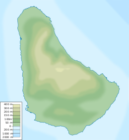
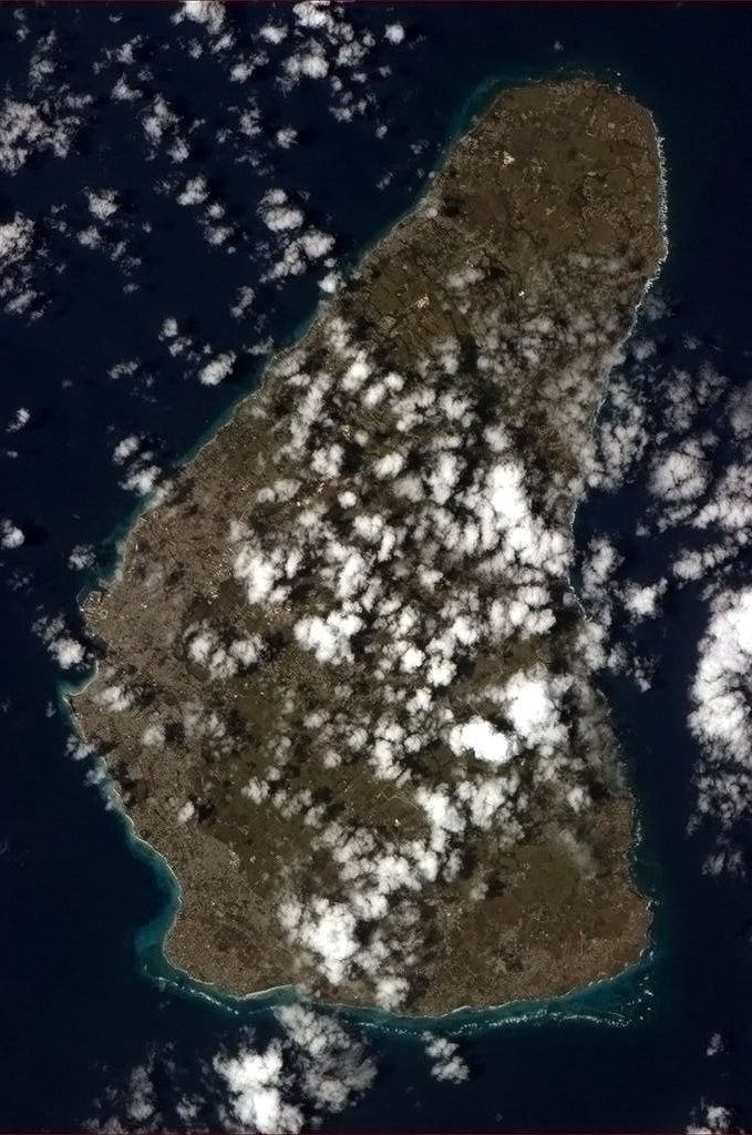
Barbados' total land area is 430 km2 (166.0 sq mi), and it has a coastline of 97 km (60 mi) length.[4] Sometimes compared to a pear[5] or leg of mutton for its physical shape. Along the north–south axis Barbados has a maximum length of 34 kilometres (21 mi), and east–west maximum breadth of 23 kilometres (14 mi).
Physical characteristics
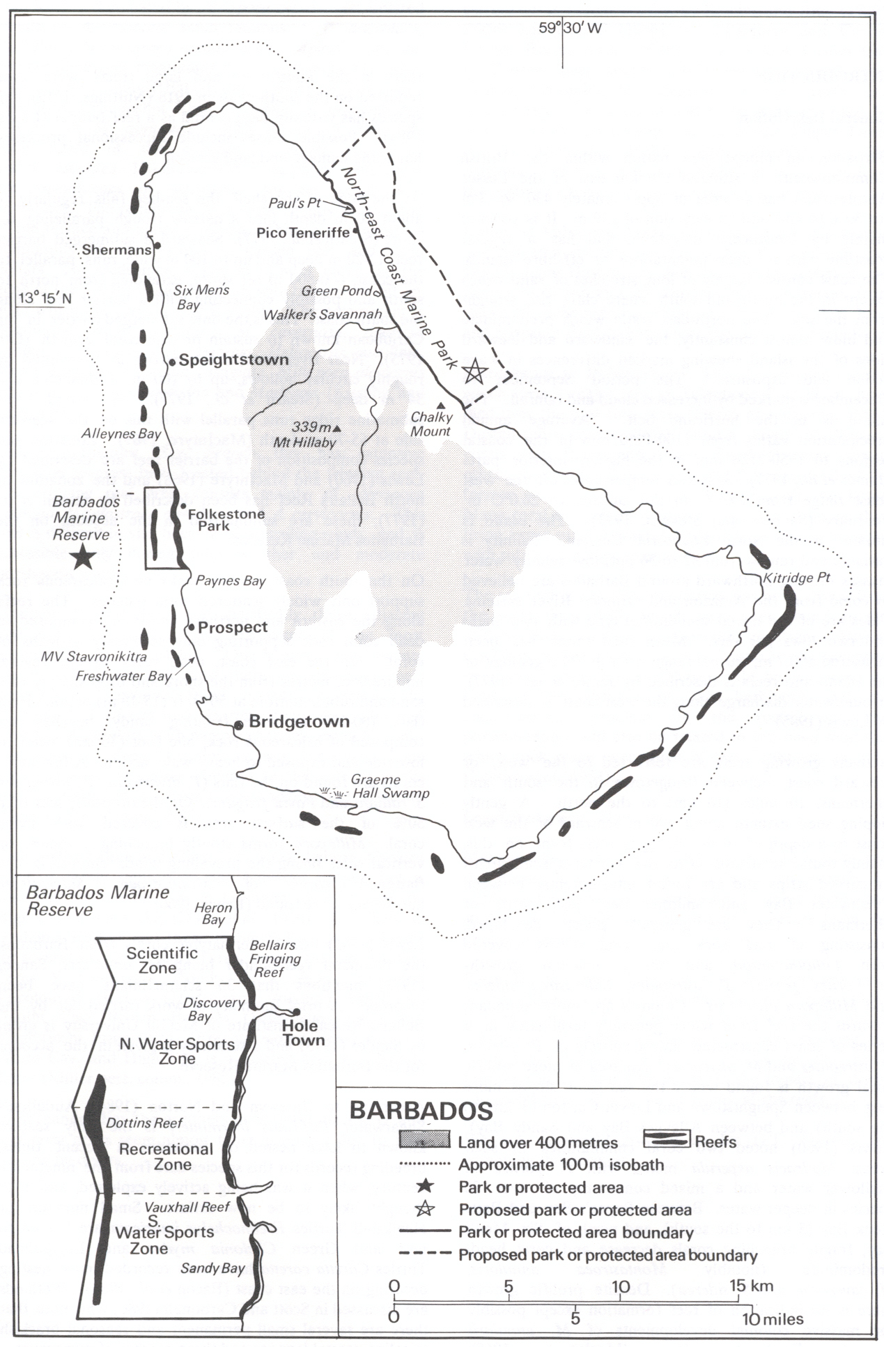
The physical characteristics of Barbados are its lowlands or gently sloping, terraced plains, separated by rolling hills that generally parallel the coasts.[6] Elevations in the interior range from 180 to 240 meters above sea level. Mount Hillaby is the highest point at 340 meters above sea level.[6] Farther south, at Christ Church Ridge, elevations range from sixty to ninety meters.[6] Eighty-five percent of the island's surface consists of coralline limestone twenty-four to thirty meters thick; Scotland District contains outcroppings of oceanic formations at the surface, however.[6] Sugarcane is planted on almost 80 percent of the island's limestone surface.[6] The soils vary in fertility; erosion is a problem, with crop loss resulting from landslides, washouts, and falling rocks.[6] Most of the small streams are in Scotland District.[6] The rest of the island has few surface streams; nevertheless, rainwater saturates the soil to produce underground channels such as the famous Coles Cave.[6] Also notable in the island is the rocky cape known as Pico Teneriffe[7] or Pico de Tenerife, which is named after the fact that the island of Tenerife in Spain is the first land east of Barbados according to the belief of the locals.
Populated places
List of: Cities, towns and villages in Barbados.
- Bridgetown
- Holetown
- Oistins
- Six Cross Roads
- Speightstown
- Saint Lawrence Gap
- Warrens
- Black Rock, Barbados
- Bank Hall
Proposed developments
In 2009[8] and 2010, members of the upscale real estate industry in Barbados proposed the creation of artificial islands to be placed off the west coast. According to Paul Altman of Altman Realty the envisioned plan, would consist of two islands, one measuring 250 acres (1.0 km2) in size, and would house new tourism based developments and upscale boutique shops; while the second island would be 50 acres (200,000 m2) in size, and would serve as an open national park. Both proposed islands would be a short distance from the Deep Water Harbour in Bridgetown.[9][10]
The south-eastern part of the island has undergone small scale oil and gas capturing from possibly as early as 1919 when the British Union Oil Company acquired over 75% of the drilling rights in Barbados.[11] Similar to Trinidad and Tobago to the southwest, the territorial Atlantic Ocean surrounding Barbados has been found to contain fossil fuels, however ongoing research is being conducted to give estimates of actual quantities.[12][13]
Time zone
Barbados is in the Eastern Caribbean Time Zone. Barbados no longer observes Daylight Saving Time. It was last used between Sunday, 20 April 1980 at 2:00 AM and Thursday, 25 September 1980 at 2:00 AM. On 25 September of that year the clock was shifted from -3:00 to -4:00, where it has remained since.
Statistics
Location

- Barbados is Caribbean: an island between the Caribbean Sea and the North Atlantic Ocean, northeast of Venezuela
- Map references
- Central America and the Caribbean
Area
- Total: 430 km²
- Land: 430 km²
- Water: 0 km²
Area comparative
- Australia comparative: less than one-fifth of the area of the Australian Capital Territory
- Canada comparative: slightly larger than London in the Province of Ontario
- United Kingdom comparative: slightly larger than the Isle of Wight or Saint Helena
- United States comparative: 2.5 times the size of Washington, DC, about the size of San Antonio, Texas, or half the size of New York City
Land boundaries
- 0 km
- Coastline
- 97 km
- Maritime claims
-
- Territorial sea: 12 nmi (22.2 km; 13.8 mi)
- Exclusive economic zone: 186,898 km2 (72,162 sq mi) and 200 nmi (370.4 km; 230.2 mi)
Climate
- Tropical; rainy season (June to October)
Terrain
- Relatively flat; rises gently to central highland region
- Extreme points
- Northernmost point – North Point, Saint Lucy
- Southernmost point – South Point, Silver Sands, Christ Church
- Westernmost point – Harrison Point, Saint Lucy
- Easternmost point – Kitridge Point, Saint Philip
- Lowest point: Atlantic Ocean: 0 m
- Highest point: Mount Hillaby: 336 m
Natural resources
- Fish, natural gas
Land use
- Arable land: 25.58%
- Permanent crops: 2.33%
- Other: 72.09% (2012)
- Irrigated land
- 54.35 km² (2003)
- Total renewable water sources
- 0.08 cu km (2011)
- Freshwater withdrawal (domestic/industrial/agricultural)
- total: 0.1 cu km/yr (20%/26%/254)
- per capita: 371.3 cu m/yr (200p)
Natural hazards
- Infrequent hurricanes; periodic landslides; periodic flooding, from storm surge and intense rainfall events; and occasional droughts, causing fires.
Environment - current issues
- Pollution of coastal waters from waste disposal by ships; soil erosion; illegal solid waste disposal threatens contamination of aquifers
- Environment - international agreements
-
- Party to: Biodiversity, Climate Change, Climate Change-Kyoto Protocol, Desertification, Endangered Species, Hazardous Wastes, Law of the Sea, Marine Dumping, Ozone Layer Protection, Ship Pollution, Wetlands
- Signed, but not ratified: none of the selected agreements
- Geography - note
- Easternmost Caribbean island
Climate
Barbados lies within the tropics.[6] Its generally pleasant maritime climate is influenced by northeast trade winds, which moderate the tropical temperature.[6] Cool, northeasterly trade winds are prevalent during the December to June dry season.[6] The overall annual temperature ranges from 24 to 28 °C (75.2 to 82.4 °F); slightly lower temperatures prevail at higher elevations.[6] Humidity levels are between 71 percent and 76 percent year round. Rainfall occurs primarily between July and December and varies considerably with elevation.[6] Rainfall may average 1,875 millimeters (73.8 in) per year in the higher central area as compared with 1,275 millimeters (50.2 in) in the coastal zone.[6]
| Climate data for Bridgetown (Grantley Adams International Airport) 1991–2020, extremes 1944–present | |||||||||||||
|---|---|---|---|---|---|---|---|---|---|---|---|---|---|
| Month | Jan | Feb | Mar | Apr | May | Jun | Jul | Aug | Sep | Oct | Nov | Dec | Year |
| Record high °C (°F) | 32.0 (89.6) |
31.2 (88.2) |
31.9 (89.4) |
32.6 (90.7) |
33.1 (91.6) |
32.7 (90.9) |
32.4 (90.3) |
35.0 (95.0) |
33.3 (91.9) |
33.3 (91.9) |
33.3 (91.9) |
31.3 (88.3) |
35.0 (95.0) |
| Average high °C (°F) | 29.1 (84.4) |
29.2 (84.6) |
29.7 (85.5) |
30.2 (86.4) |
30.6 (87.1) |
30.7 (87.3) |
30.7 (87.3) |
30.9 (87.6) |
31.0 (87.8) |
30.8 (87.4) |
30.3 (86.5) |
29.6 (85.3) |
30.2 (86.4) |
| Daily mean °C (°F) | 26.0 (78.8) |
25.9 (78.6) |
26.3 (79.3) |
27.0 (80.6) |
27.7 (81.9) |
27.8 (82.0) |
27.8 (82.0) |
27.9 (82.2) |
27.9 (82.2) |
27.7 (81.9) |
27.2 (81.0) |
26.6 (79.9) |
27.2 (80.9) |
| Average low °C (°F) | 23.3 (73.9) |
23.0 (73.4) |
23.4 (74.1) |
24.2 (75.6) |
25.0 (77.0) |
25.2 (77.4) |
25.1 (77.2) |
24.8 (76.6) |
24.8 (76.6) |
24.7 (76.5) |
24.5 (76.1) |
23.9 (75.0) |
24.3 (75.8) |
| Record low °C (°F) | 16.0 (60.8) |
16.0 (60.8) |
16.0 (60.8) |
19.0 (66.2) |
19.4 (66.9) |
20.0 (68.0) |
19.3 (66.7) |
19.1 (66.4) |
20.6 (69.1) |
20.6 (69.1) |
18.0 (64.4) |
17.4 (63.3) |
16.0 (60.8) |
| Average rainfall mm (inches) | 68.1 (2.68) |
41.7 (1.64) |
38.9 (1.53) |
58.1 (2.29) |
74.1 (2.92) |
101.2 (3.98) |
121.5 (4.78) |
150.6 (5.93) |
162.6 (6.40) |
179.6 (7.07) |
172.6 (6.80) |
91.0 (3.58) |
1,260 (49.6) |
| Average rainy days | 11 | 9 | 8 | 8 | 8 | 11 | 15 | 16 | 13 | 15 | 14 | 11 | 139 |
| Average relative humidity (%) | 77 | 76 | 75 | 76 | 77 | 79 | 80 | 81 | 81 | 82 | 82 | 78 | 79 |
| Mean monthly sunshine hours | 263.5 | 248.6 | 272.8 | 261.0 | 263.5 | 225.0 | 251.1 | 260.4 | 234.0 | 238.7 | 228.0 | 254.2 | 3,000.8 |
| Mean daily sunshine hours | 8.5 | 8.8 | 8.8 | 8.7 | 8.5 | 7.5 | 8.1 | 8.4 | 7.8 | 7.7 | 7.6 | 8.2 | 8.2 |
| Source 1: Barbados Meteorological Services[14] | |||||||||||||
| Source 2: Meteo Climat (record highs and lows)[15] | |||||||||||||
Disputes
Guyana's and Barbados's offshore territorial claims overlap, and are also disputed with Venezuela,[16] which itself claims ownership of the waters overlapping the first two.[17] In 2008 Barbados sought to place the oil blocks on open market for oil exploration tender but faced a challenge by Venezuela's government in Caracas.[18]
In 2006 a local Barbadian group purporting to represent descendants of indigenous Caribbean peoples announced its claim to Culpepper Island, a small rocky outcrop on the eastern shore of Barbados.[19]
Notes
- "Windward Islands". Encyclopædia Britannica.
a line of West Indian islands constituting the southern arc of the Lesser Antilles, at the eastern end of the Caribbean Sea, between latitudes 12° and 16° N and longitudes 60° and 62° W. They include, from north to south, the English-speaking island of Dominica; the French département of Martinique; the English-speaking islands of Saint Lucia, Saint Vincent, and Grenada; and, between Saint Vincent and Grenada, the chain of small islands known as the Grenadines. Though near the general area, Trinidad and Tobago (at the south end of the group) and Barbados (just east) are usually not considered part of the Windward Islands.
- Joseph, Cedric. "Border Controversies and their Implications for Stability and Security of the Caribbean Community". UWI-CARICOM Project. Archived from the original on 2014-10-22.
The Bahamas, one of six CARICOM States to claim archipelago status, with a total coastline of 11,238 km, is reported to have the largest claim to EEZ of 369,149 sq km. Barbados, with a total coastline of some 97 km and a relatively small continental shelf of 213 sq km, reportedly has a claim to some 183,436 sq km of exclusive economic zone.
- Staff writer (8 August 2007). "BID Blocks carrying local names". Government of Barbados. Archived from the original on October 3, 2011. Retrieved 20 December 2010.
Barbados is 341(TYPO?) square kilometres in size and 70,000 sq km of its marine territorial space has been made available for the offshore hydrocarbon exploration. This means that the acreage on the market is about 162 times the size of the island’s land space.
- "DSD :: Areas of Work :: SIDS - SIDS Members - the Caribbean".
- Pariser, Harry S. (October 2000). Explore Barbados. Vol. 3. Manatee Press. ISBN 1-893643-51-4. Retrieved 2009-12-29.
Forewords & Introductions: "Just 21 mi. long by a "smile" wide, Barbados is an island of dramatic contrasts and offers many picture-postcard terrains. The island's shape has been compared to that of a ham, a leg of mutton, a pear-shaped emerald, or a lopsided pear with the stem end pointing north.
- Meyerson, Beatrice Berle; Hornbeck, John F.; Haggerty, Richard A. (1987). "Barbados: Geography". In Meditz, Sandra W.; Hanratty, Dennis M. (eds.). Islands of the Commonwealth Caribbean: a regional study. Washington, D.C.: Federal Research Division, Library of Congress. pp. 390–391. LCCN 88600483.
- Pico Teneriffe
- Thorne, Peter (25 February 2009). "An island north of the harbour". Caribbean Broadcasting Corporation (CBC). Archived from the original on March 3, 2016. Retrieved 10 March 2010.
- Riley-Thornhill, Janelle (10 March 2010). "Artificial islands a viable option?". Barbados Advocate. Archived from the original on February 26, 2012. Retrieved 10 March 2010.
- E., G. (2 March 2010). "2 man-made islands to add value to tourism product". Nation Newspaper. Archived from the original on March 8, 2010. Retrieved 10 March 2010.
- BRITISH COMMERCIAL INTERESTS IN BARBADOS, HL Deb 18 April 1951 vol 171 cc376-404
- B., J. (2 August 2010). "Business Monday: Boyce speaks on Barbados' search for oil". Barbados Advocate. Archived from the original on March 11, 2012. Retrieved 2 August 2010.
- "2D Long Offset Seismic". Archived from the original on 2011-07-06. Retrieved 2010-12-20.
- "Barbados Weather Climate Data". Barbados Meteorological Services. Retrieved 6 January 2022.
- "Station Grantley" (in French). Meteo Climat. Retrieved 6 November 2016.
- How Trinidad Recognised Venezuela’s Claim to Most Of Guyana’s Land 18 June 2007, Notes From The Margin
- Marginal Picks Up His Pen – Venezuelas Claim of Barbados’ Waters 16 June 2008, Notes From The Margin
- NGO reports Barbados is bidding oil blocks in Venezuelan waters 28 July 2008, El Universal
- "The Reclamation of Culpepper Island by the Lokono-Arawak and Karifuna-Carib Nations"
References
 This article incorporates public domain material from World Factbook. CIA.
 Geographic data related to Barbados at OpenStreetMap
- . Encyclopædia Britannica. Vol. 3 (11th ed.). 1911. pp. 380–381.
 Wikimedia Atlas of Barbados
- Schomburgk, Sir Robert Hermann (2001) [1848]. The history of Barbados (6th ed.). Frank Cass Publishers. ISBN 0-7146-1948-5. Retrieved 12 July 2010.
- Bensley, Jessica (2009). Skyviews Atlas Barbados (Ed. 1 ed.). Skyviews Caribbean. ISBN 978-976-95231-0-4. Retrieved 19 December 2010.
- Evans, Chris (2009). "Land slides and tourist development: The slow slide of eastern Barbados into the sea". Earthwise. British Geological Survey (14): 17. ISSN 0967-9669.
- Caves and landslips in Barbados - September 16, 2007: Barbados Advocate
- Geography & Climate of Barbados - Barbados Government
- Earthwise Issue 14, Landslides and tourist development - The slow slide of eastern Barbados into the sea, British Geological Survey
- Plantation and Peasant Farm A Vertical Theme in the Historical Geography of Barbados 1627 - 1960 by Frank Cecil Innes, M.A., B.Sc, September, 1967, Doctor of Philosophy, Dept. of Geography, McGil1 Univ.
See also
- English place names in Barbados
External links
- Caribbean-On-Line.com provides detailed maps of Barbados.
- Districts of Barbados, Statoids.com
- GEOnet Names Server
- BajanNAV - Free satellite navigation software for Barbados
- Barbados Geography geographic profile of Barbados.
- Encyclopedia.com Worldmark Encyclopedia of Nations.
- Encyclopaedia Britannica, Inc. Physical Geography
Geography of the Americas | ||
|---|---|---|
| ||
| Sovereign states |
|  |
Dependencies and other territories |
| |
Climate of the Americas | ||
|---|---|---|
| ||
| Sovereign states |
| |
Dependencies and other territories |
| |
На других языках
- [en] Geography of Barbados
[es] Geografía de Barbados
Barbados es una isla localizada entre el mar Caribe oriental y el océano Atlántico occidental, al noreste de Venezuela y Trinidad y Tobago, en un punto excéntrico del arco insular externo del mar Caribe. Está situada a 13° 10' de latitud norte del ecuador y 59° 32' de longitud oeste del meridiano de Greenwich.[fr] Géographie de la Barbade
La Barbade est un État et une île des Antilles. La langue officielle y est l'anglais, bien que la langue maternelle de la quasi-totalité de la population (environ 90 %) soit un pidgin appelé bajan.Другой контент может иметь иную лицензию. Перед использованием материалов сайта WikiSort.org внимательно изучите правила лицензирования конкретных элементов наполнения сайта.
WikiSort.org - проект по пересортировке и дополнению контента Википедии