geo.wikisort.org - Island
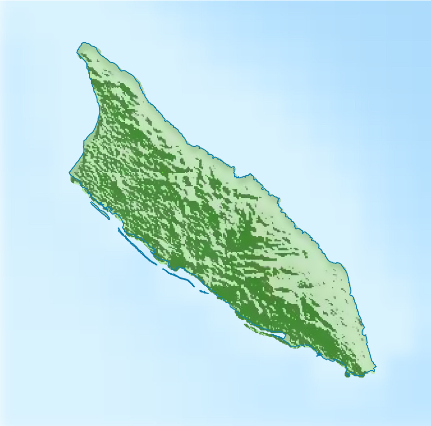
Aruba is an island in the south of the Caribbean in the Caribbean Sea. It is westernmost island of the ABC Islands and of the Leeward Antilles. It is located 25 km north of the coast of Venezuela and 68 km northwest of Curaçao. The island has a total area of 193 km2 (75 sq mi) and a coast line of 68.5 km (42.6 mi). Mount Jamanota of 188 m (617 ft) is the highest point.
This article needs additional citations for verification. (June 2015) |
 Satellite image of Aruba | |||||||||||||||||||||||||
 Aruba  Aruba  Aruba | |||||||||||||||||||||||||
| Geography | |||||||||||||||||||||||||
|---|---|---|---|---|---|---|---|---|---|---|---|---|---|---|---|---|---|---|---|---|---|---|---|---|---|
| Location | Caribbean | ||||||||||||||||||||||||
| Coordinates | 12°30′N 69°58′W | ||||||||||||||||||||||||
| Archipelago | Leeward Islands, Lesser Antilles | ||||||||||||||||||||||||
| Administration | |||||||||||||||||||||||||
| Additional information | |||||||||||||||||||||||||
| Time zone |
| ||||||||||||||||||||||||
| |||||||||||||||||||||||||
Politically, Aruba is a constituent country of the Kingdom of the Netherlands. Oranjestad is the largest settlement with a population of 32,748.
Geography
Geology
Aruba is situated on the Caribbean Tectonic Plate. Aruba, as well as the rest of the ABC islands and also Trinidad and Tobago, lies on the continental shelf of South America, and is thus geologically considered to lie entirely in South America.
The core of the island is made up of Turonian submarine and subaerial basalts which were formed in the Caribbean large igneous province. These basalts were intruded by a pluton shortly after their eruption. The shore areas are mainly limestone.
Mountains and hills
Aruba is almost entirely flat. The two most known rock formations are Ayo Rock Formations and Casibari, both are tourist attractions.
Along the northern coast it is more hilly, especially in the Arikok National Park. The highest elevation, known as Mount Jamanota, is only 188 m (617 ft) above sea level and the Arikok itself is 186 m (610 ft). The Hooiberg is 165 m (541 ft). While the Hooiberg is not the highest point on the island, it does look so, because of the flat surroundings it lies in. The Hooiberg can be seen from nearly every point of the island and is so known it has its on place on the Coat of arms of Aruba.
Coast and beaches
While Aruba's northern coast is rocky and mostly formed by corral plateaus with many small sandy bay like openings called 'Bocas', Papiamento for mouths. The sea is rough and dark blue compared with the southern coastal areas and swimming here is discouraged.
Climate
Aruba has a hot semi-arid climate (Köppen BSh) and nearly constant temperatures throughout the year.
The rainy season occurs between September and January, but exhibits very high variability due to the powerful influence of the Southern Oscillation.[1] During strong El Niño years like 1911/1912, 1930/1931, 1982/1983 and 1997/1998 annual (fiscal year) rainfall can be as little as 150 millimetres or 6 inches, while in contrast, as much as 1,000 millimetres or 39 inches may fall during a strong La Niña year like 1933/1934, 1970/1971, 1988/1989, 1999/2000 or 2010/2011. The highest monthly totals during these La Niña events are between 350 and 400 millimetres (14 and 16 in).
| Climate data for Oranjestad, Aruba (normals 1991-2020, extremes 1951-2020) | |||||||||||||
|---|---|---|---|---|---|---|---|---|---|---|---|---|---|
| Month | Jan | Feb | Mar | Apr | May | Jun | Jul | Aug | Sep | Oct | Nov | Dec | Year |
| Record high °C (°F) | 32.5 (90.5) |
33.0 (91.4) |
33.9 (93.0) |
34.4 (93.9) |
34.9 (94.8) |
35.2 (95.4) |
35.3 (95.5) |
36.1 (97.0) |
36.5 (97.7) |
35.4 (95.7) |
35.0 (95.0) |
34.8 (94.6) |
36.5 (97.7) |
| Average high °C (°F) | 30.3 (86.5) |
30.6 (87.1) |
31.1 (88.0) |
31.9 (89.4) |
32.0 (89.6) |
32.5 (90.5) |
32.4 (90.3) |
33.2 (91.8) |
33.2 (91.8) |
32.4 (90.3) |
31.5 (88.7) |
30.7 (87.3) |
31.8 (89.2) |
| Daily mean °C (°F) | 27.0 (80.6) |
27.1 (80.8) |
27.4 (81.3) |
28.2 (82.8) |
28.7 (83.7) |
29.0 (84.2) |
28.9 (84.0) |
29.5 (85.1) |
29.6 (85.3) |
29.1 (84.4) |
28.4 (83.1) |
27.5 (81.5) |
28.4 (83.1) |
| Average low °C (°F) | 24.8 (76.6) |
24.8 (76.6) |
25.3 (77.5) |
26.0 (78.8) |
26.7 (80.1) |
26.9 (80.4) |
26.7 (80.1) |
27.2 (81.0) |
27.3 (81.1) |
26.7 (80.1) |
26.0 (78.8) |
25.3 (77.5) |
26.1 (79.0) |
| Record low °C (°F) | 19.0 (66.2) |
20.6 (69.1) |
21.2 (70.2) |
21.5 (70.7) |
21.8 (71.2) |
22.7 (72.9) |
21.2 (70.2) |
21.3 (70.3) |
22.1 (71.8) |
21.9 (71.4) |
22.0 (71.6) |
20.5 (68.9) |
19.0 (66.2) |
| Average rainfall mm (inches) | 44.0 (1.73) |
19.5 (0.77) |
10.0 (0.39) |
8.6 (0.34) |
14.1 (0.56) |
17.4 (0.69) |
19.6 (0.77) |
31.4 (1.24) |
42.9 (1.69) |
76.5 (3.01) |
87.1 (3.43) |
80.1 (3.15) |
451.1 (17.76) |
| Average rainy days (≥ 1.0 mm) | 10.8 | 4.5 | 2.0 | 1.5 | 1.7 | 2.8 | 4.1 | 3.1 | 3.3 | 7.3 | 9.6 | 11.0 | 61.7 |
| Average relative humidity (%) | 77.8 | 76.2 | 75.9 | 76.9 | 77.9 | 77.4 | 77.8 | 75.6 | 76.2 | 77.9 | 78.8 | 77.9 | 77.2 |
| Source: Departamento Meteorologico Aruba[2][3][4][5] | |||||||||||||
Environmental policies
In 2016, in response to a ban of plastic bags by the government, the Minister of Finance, Economic Affair and Culture, Xiomara Ruiz-Maduro, called for further increases to Aruba's environmental initiatives. She cited the fact that no environmental protection law had yet been passed in the territory.[6]
Human geography
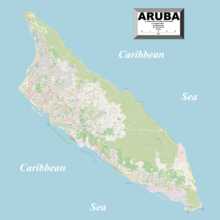
The island is divided into eight regions:
- Noord/Tanki Leendert
- Oranjestad West
- Oranjestad Oost
- Paradera
- Santa Cruz
- Savaneta
- San Nicolas Noord
- San Nicolas Zuid
References
- Dewar, Robert E. and Wallis, James R; ‘Geographical patterning of interannual rainfall variability in the tropics and near tropics: An L-moments approach’; in Journal of Climate, 12; pp. 3457-3466
- "Summary Climatological Normals Period 1991–2020" (PDF). Departamento Meteorologico Aruba. Archived (PDF) from the original on 15 February 2021. Retrieved 14 February 2021.
- "Summary Climatological Normals Period 1951–1980" (PDF). Departamento Meteorologico Aruba. Retrieved 14 February 2021.
{{cite web}}: CS1 maint: url-status (link) - "Summary Climatological Normals Period 1971–2000" (PDF). Departamento Meteorologico Aruba. Retrieved 14 February 2021.
{{cite web}}: CS1 maint: url-status (link) - "Summary Climatological Normals Period 1981–2010" (PDF). Departamento Meteorologico Aruba. Retrieved 14 February 2021.
{{cite web}}: CS1 maint: url-status (link) - "Plastic tasjes volgend jaar verboden op Aruba | Caribisch Netwerk". caribischnetwerk.ntr.nl (in Dutch). 2016-06-30. Retrieved 2022-01-28.
External links
 Wikimedia Atlas of Aruba
- "Map of Aruba" (PDF).
- Map of Aruba
- Maps of Aruba (including island map, and detail maps of Oranjestad and San Nicolas)
Aruba articles | |||||||
|---|---|---|---|---|---|---|---|
| |||||||
| Geography |
|  | |||||
| Politics |
| ||||||
| Economy |
| ||||||
| Culture |
| ||||||
| See also |
| ||||||
| |||||||
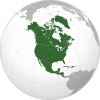
Geography of North America | ||
|---|---|---|
| Sovereign states |
|  |
Dependencies and other territories |
| |
Другой контент может иметь иную лицензию. Перед использованием материалов сайта WikiSort.org внимательно изучите правила лицензирования конкретных элементов наполнения сайта.
WikiSort.org - проект по пересортировке и дополнению контента Википедии