geo.wikisort.org - Island
Elikalpeni Bank is a submerged bank or sunken atoll belonging to the Amindivi Subgroup of islands of the Union Territory of Lakshadweep, India.[3]
 Elikalpeni Bank | |
| Geography | |
|---|---|
| Location | Arabian Sea |
| Coordinates | 11.20°N 73.96°E |
| Type | Submerged bank |
| Archipelago | Lakshadweep |
| Adjacent bodies of water | Indian Ocean |
| Total islands | 0 |
| Area | 0 km2 (0 sq mi)[1] |
| Highest elevation | −10.4 m (-34.1 ft) |
| Administration | |
India | |
| Territory | Union territory of Lakshadweep |
| District | Lakshadweep |
| Island group | Aminidivi |
| Tehsils of India | Aminidivi |
| Subdivisions of India | Amini Island |
| Demographics | |
| Population | 0 (2014) |
| Pop. density | 0/km2 (0/sq mi) |
| Ethnic groups | Malayali, Mahls |
| Additional information | |
| Time zone |
|
| ISO code | IN-LD-00[2] |
| Official website | www |
| Avg. summer temperature | 32.0 °C (89.6 °F) |
| Avg. winter temperature | 28.0 °C (82.4 °F) |
Geography
Elikalpeni Bank has a minimum depth of 10.4 m and is located 57 km northeast of Androth[4] at 11°12′N 73°58′E.[5]
Elikalpeni Bank is the easternmost geographic feature of the Lakshadweep Archipelago, although other little researched banks with depths of as little as 18.3 m lie about 32 km east of Elikalpeni.[4] It has a lagoon area of 95.91 km2 (37.03 sq mi).
Image gallery
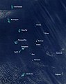 Satellite picture showing the atolls of the Lakshadweep except for Minicoy
 Map
Map


References
- "Islandwise Area and Population - 2011 Census" (PDF). Government of Lakshadweep. Archived from the original (PDF) on 22 July 2016.
- Registration Plate Numbers added to ISO Code
- Hydrographic Description (Indian Ocean Pilot)
- Prostar Sailing Directions 2005 India & Bay of Bengal Enroute, National Geospatial-intelligence Agency
- GEBCO Gazeteer of undersea feature names
External links
This article related to a location in the Indian union territory of Lakshadweep Islands is a stub. You can help Wikipedia by expanding it. |
Текст в блоке "Читать" взят с сайта "Википедия" и доступен по лицензии Creative Commons Attribution-ShareAlike; в отдельных случаях могут действовать дополнительные условия.
Другой контент может иметь иную лицензию. Перед использованием материалов сайта WikiSort.org внимательно изучите правила лицензирования конкретных элементов наполнения сайта.
Другой контент может иметь иную лицензию. Перед использованием материалов сайта WikiSort.org внимательно изучите правила лицензирования конкретных элементов наполнения сайта.
2019-2026
WikiSort.org - проект по пересортировке и дополнению контента Википедии
WikiSort.org - проект по пересортировке и дополнению контента Википедии