geo.wikisort.org - Island
Elephantine (/ˌɛlɪfænˈtaɪniː, -ˈtiː-/ EL-if-an-TY-nee, -TEE-;[2] Ancient Egyptian: ꜣbw; Egyptian Arabic: جزيرة الفنتين, romanized: Gazīrat il-Fantīn; Greek: Ἐλεφαντίνη Elephantíne; Coptic: (Ⲉ)ⲓⲏⲃ (Ə)iêw) is an island on the Nile, forming part of the city of Aswan in Upper Egypt. The archaeological sites on the island were inscribed on the UNESCO World Heritage List in 1979 along with other examples of Upper Egyptian architecture, including Abu Simbel and Philae.[3]
Native name: جزيرة فيلة (Ⲉ)ⲓⲏⲃ | |
|---|---|
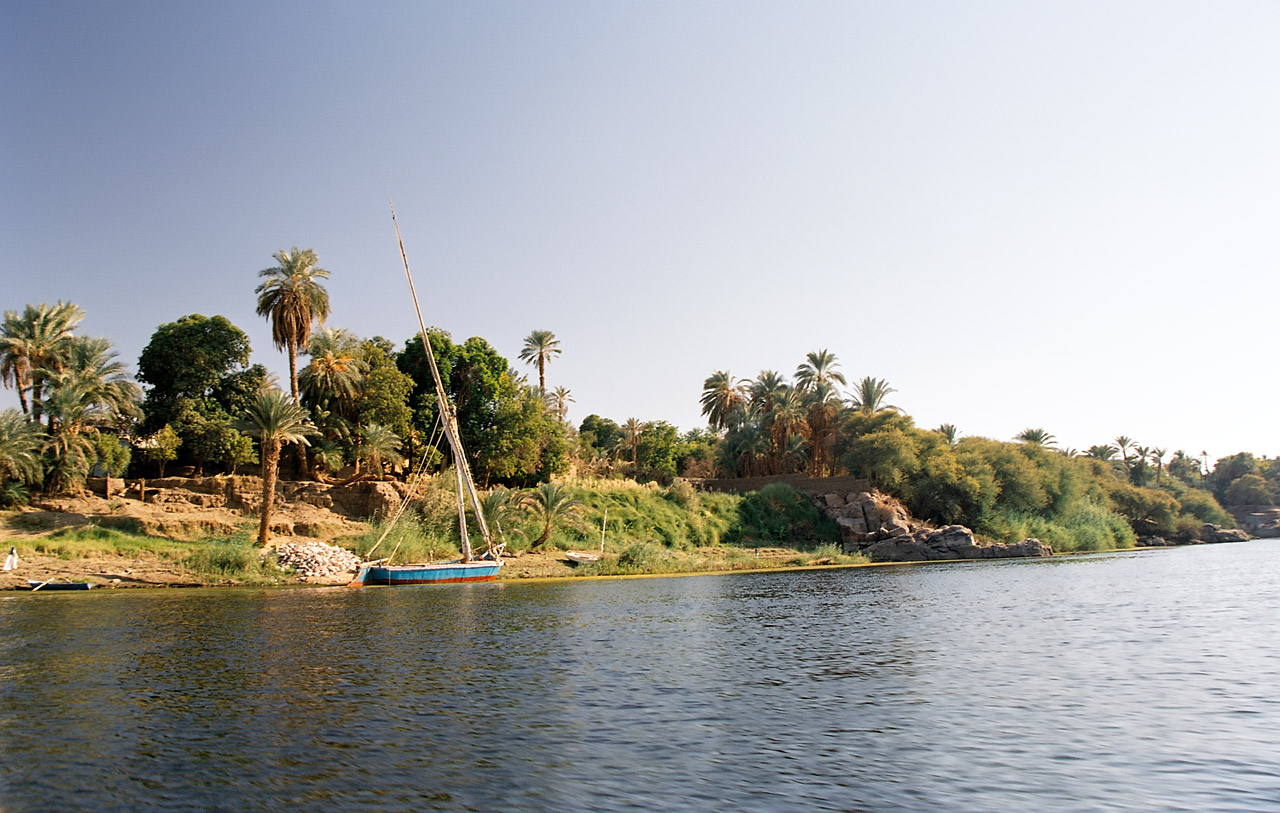 West bank of Elephantine Island on the Nile | |
 Elephantine Location in the Nile at Aswan, Upper Egypt | |
| Geography | |
| Coordinates | 24.09°N 32.89°E |
| Adjacent to | Nile |
| Length | 1,200 m (3900 ft) |
| Width | 400 m (1300 ft) |
| Administration | |
Egypt | |
| 3bw "Elephantine"[1] | ||||||
|---|---|---|---|---|---|---|
| Egyptian hieroglyphs |
Geography
This section does not cite any sources. (September 2021) |
Elephantine is 1,200 metres (3,900 ft) from north to south, and is 400 metres (1,300 ft) across at its widest point. The layout of this and other nearby islands in Aswan can be seen from west bank hillsides along the Nile. The island is located just downstream of the First Cataract, at the southern border of Upper Egypt with Lower Nubia. This region above is referred to as Upper Egypt because it is further up the Nile.
The island may have received its name after its shape, which in aerial views is similar to that of an elephant tusk, or from the rounded rocks along the banks resembling elephants.
Ancient Egypt
Known to the ancient Egyptians as ꜣbw "Elephant" (Middle Egyptian: /ˈʀuːbaw/ → Medio-Late Egyptian: /ˈjuːbəʔ/ → Coptic: (Ⲉ)ⲓⲏⲃ /ˈjeβ/, preserved in its Hebrew name, יֵב 'yev'), the island of Elephantine stood at the border between Egypt and Nubia. It was an excellent defensive site for a city and its location made it a natural cargo transfer point for river trade. This border is near the Tropic of Cancer, the most northerly latitude at which the sun can appear directly overhead at noon and from which it appears to reverse direction or "turn back" at the solstices.
Elephantine was a fort that stood just before the First Cataract of the Nile. During the Second Intermediate Period (1650–1550 BC), the fort marked the southern border of Egypt.[4]
Historical texts from the Middle Kingdom of Egypt mention the mother of Amenemhat I, founder of the Twelfth Dynasty, being from[5] the Elephantine Egyptian nome Ta-Seti.[6][7][8] Many scholars have argued that Amenemhat I's mother was of Nubian origin.[9][10][11][12][13][14][15][16]
According to the ancient Egyptian religion, Elephantine was the dwelling place of Khnum, the ram-headed god of the cataracts, who guarded and controlled the waters of the Nile from caves beneath the island. He was worshipped here as part of a late triad of Egyptian deities. This "Elephantine Triad" included Satis and Anuket. Satis was worshipped from very early times as a war goddess and protector of this strategic region of Egypt. When seen as a fertility goddess, she personified the bountiful annual flooding of the Nile, which was identified as her daughter, Anuket. The cult of Satis originated in the ancient city of Aswan. Later, when the triad was formed, Khnum became identified as her consort and, thereby, was thought of as the father of Anuket. His role in myths changed later and another deity was assigned his duties with the river. At that time his role as a potter enabled him to be assigned a duty in the creation of human bodies.

Archaeological sites
Ongoing excavations by the German Archaeological Institute at the town have uncovered many findings, on display in the Aswan Museum located on the island, including a mummified ram of Khnum. Artifacts dating back to prehistoric Egypt have been found on Elephantine. A rare calendar, known as the Elephantine Calendar of Things, which dates to the reign of Thutmose III during the Eighteenth Dynasty, was found in fragments on the island.
In ancient times the island was also an important stone quarry, providing granite for monuments and buildings all over Egypt.
Temples

Prior to 1822, there were temples to Thutmose III and Amenhotep III[17] on the island. In 1822, they were destroyed during the campaign of Muhammad Ali, who had taken power in Egypt, to conquer Sudan. Both temples were relatively intact prior to the deliberate demolition.[citation needed]
The first temple was the Temple of Satet, it was founded around 3000 BC and enlarged and renovated over the next 3,000 years. There are records of an Egyptian temple to Khnum on the island as early as the Third Dynasty. This temple was completely rebuilt in the Late Period, during the Thirtieth Dynasty of Egypt, just before the foreign rule that followed in the Graeco-Roman Period. The Greeks formed the Ptolemaic dynasty during their three-hundred-year rule over Egypt (305–30 BC) and maintained the ancient religious customs and traditions, while often associating the Egyptian deities with their own.
Most of the present day southern tip of the island is taken up by the ruins of the Temple of Khnum. These, the oldest ruins still standing on the island, are composed of a granite step pyramid from the Third Dynasty and a small temple built for the local Sixth Dynasty nomarch, Heqaib. In the Middle Kingdom, many officials, such as the local governors Sarenput I or Heqaib III, dedicated statues and shrines into the temple.


Nilometers
A nilometer was a structure for measuring the Nile River's clarity and the water level during the annual flood season. There are two nilometers at Elephantine Island. The more famous is a corridor nilometer associated with the Temple of Satis, with a stone staircase that descends the corridor. It is one of the oldest nilometers in Egypt, last reconstructed in Roman times and still in use as late as the nineteenth century AD. Ninety steps that lead down to the river are marked with Arabic, Roman, and hieroglyphic numerals. Visible at the water's edge are inscriptions carved deeply into the rock during the Seventeenth Dynasty.
The other Nilometer is a rectangular basin located at the island's southern tip, near the Temple of Khnum and opposite the Old Cataract Hotel. It is probably the older of the two. One of the nilometers, though it is not certain which, is mentioned by the Greek historian Strabo.
Many sources claim that the fabled "Well of Eratosthenes", famous in connection with Eratosthenes' presumed calculation of the Earth's circumference, was located on the island. Strabo mentions a well that was used to observe that Aswan lies on the Tropic of Cancer, but the reference is to a well at Aswan, not at Elephantine. Neither nilometer at Elephantine is suitable for the purpose, while the well at Aswan is apparently lost. [18]
Jewish presence
The Elephantine papyri are caches of legal documents and letters written in Aramaic dating to sometime in the fifth century BC.[19][20] These papyri document the presence of a community of Judean mercenaries and their families on Elephantine, starting in the seventh century BCE. The mercenaries guarded the frontier between Egypt and Nubia to the south.[21] Following the Babylonian destruction of Jerusalem in the sixth century BCE, some Judean refugees traveled south and, in what may be called an “exodus in reverse,” settled on Elephantine. They maintained their own temple (also see House of Yahweh), in which sacrifices were offered, evincing polytheistic beliefs, which functioned alongside that of Khnum.[22] The temple was destroyed in 410 BC at the instigation of the priests of Khnum.
The temple may have been built in reaction to Manasseh's reinstitution of pagan worship or simply to serve the needs of the Jewish community.[19]
Other features
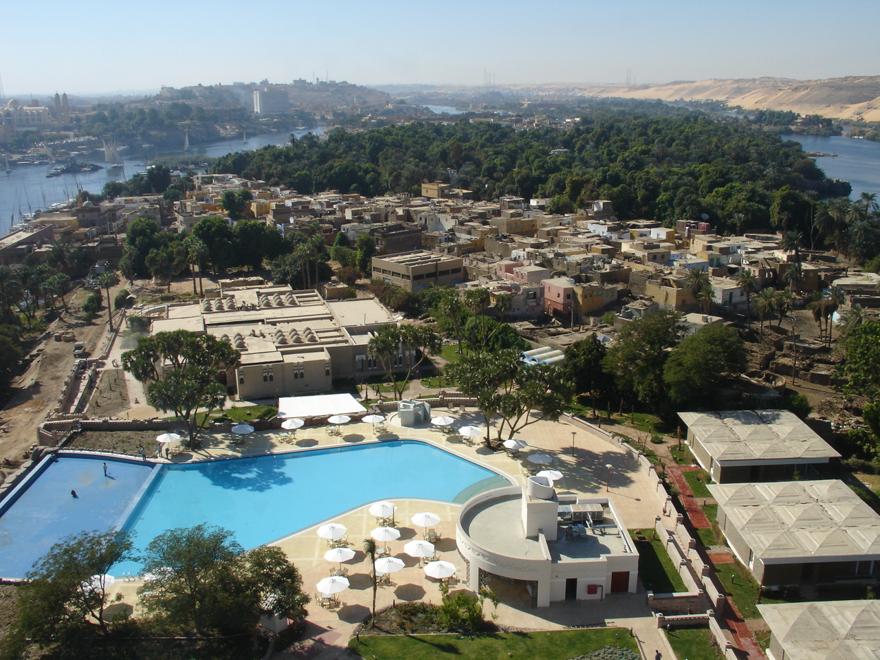
The Aswan Museum is located at the southern end of the island. Ongoing excavations by the German Archaeological Institute at the island's ancient town site have uncovered many findings that are now on display in the museum, including a mummified ram of Khnum. A sizable population of Nubians live in three villages in the island's middle section. A large luxury hotel is at the island's northern end.
The Aswan Botanical Garden is adjacent to the west on el Nabatat Island.
Gallery
 Nubian houses on central Elephantine Island
 Verdant Elephantine Island, opposite Assuan, Egypt", 1908. Lantern slide. Brooklyn Museum
 Island of Elephantine, by Edwin Howland Blashfield. Brooklyn Museum
 Ruins on Elephantine Island in 2000


See also
- Sehel Island
- Temple of Satet
References
- "3bw" in Faulkner, Concise Dictionary of Middle Egyptian cf. http://projetrosette.info/popup.php?Id=1012&idObjet=423
- Merriam-Webster's Geographical Dictionary, Third Edition (Merriam-Webster, 1997; ISBN 0877795460), p. 351.
- "Nubian Monuments from Abu Simbel to Philae". UNESCO World Heritage Centre. United Nations Educational, Scientific, and Cultural Organization. Retrieved 7 September 2021.
- Ian Shaw, Ed, Oxford History of Ancient Egypt, New York, 2000, page 206
- "Then a king will come from the South, Ameny, the justified, by name, son of a woman of Ta-seti, child of Upper Egypt""The Beginning of the Twelfth Dynasty". Kingship, Power, and Legitimacy in Ancient Egypt: From the Old Kingdom to the Middle Kingdom. Cambridge University Press: 138–160. 2020.
- "Ammenemes himself was not a Theban but the son of a woman from Elephantine called Nofret and a priest called Sesostris (‘The man of the Great Goddess’).",Grimal, Nicolas (1994). A History of Ancient Egypt. Wiley-Blackwell (July 19, 1994). p. 159.
- "Senusret, a commoner as the father of Amenemhet, his mother, Nefert, came from the area Elephantine."A. Clayton, Peter (2006). Chronicle of the Pharaohs: The Reign-by-Reign Record of the Rulers and Dynasties of Ancient Egypt. Thames & Hudson. p. 78.
- "Amenemhet I was a commoner, the son of one Sen-wosret and a woman named NEFRET, listed as prominent members of a family from ELEPHANTINE Island."Bunson, Margaret (2002). Encyclopedia of Ancient Egypt (Facts on File Library of World History). Facts on File. p. 25.
- "The XIIth Dynasty (1991–1786 B.C.E.) originated from the Aswan region. As expected, strong Nubian features and dark coloring are seen in their sculpture and relief work. This dynasty ranks as among the greatest, whose fame far outlived its actual tenure on the throne. Especially interesting, it was a member of this dynasty – that decreed that no Nehsy (riverine Nubian of the principality of Kush), except such as came for trade or diplomatic reasons, should pass by the Egyptian fortress at the southern end of the Second Nile Cataract. Why would this royal family of Nubian ancestry ban other Nubians from coming into Egyptian territory? Because the Egyptian rulers of Nubian ancestry had become Egyptians culturally; as pharaohs, they exhibited typical Egyptian attitudes and adopted typical Egyptian policies."F. J. Yurco. "'Were the ancient Egyptians black or white?'". Biblical Archaeology Review. (Vol 15, no. 5, 1989): 24–9, 58.
- General History of Africa Volume II – Ancient civilizations of Africa (ed. G Moktar). UNESCO. p. 152.
- Crawford, Keith W. (1 December 2021). "Critique of the "Black Pharaohs" Theme: Racist Perspectives of Egyptian and Kushite/Nubian Interactions in Popular Media". African Archaeological Review. 38 (4): 695–712. doi:10.1007/s10437-021-09453-7. ISSN 1572-9842. S2CID 238718279.
- Lobban, Richard A. Jr (10 April 2021). Historical Dictionary of Ancient Nubia. Rowman & Littlefield. ISBN 9781538133392.
- Morris, Ellen (6 August 2018). Ancient Egyptian Imperialism. John Wiley & Sons. p. 72. ISBN 978-1-4051-3677-8.
- Van de Mieroop, Marc (2021). A history of ancient Egypt (Second ed.). Chichester, West Sussex. p. 99. ISBN 978-1119620877.
- Fletcher, Joann (2017). The story of Egypt : the civilization that shaped the world (First Pegasus books paperback ed.). New York. pp. Chapter 12. ISBN 978-1681774565.
- Smith, Stuart Tyson (8 October 2018). "Ethnicity: Constructions of Self and Other in Ancient Egypt". Journal of Egyptian History. 11 (1–2): 113–146. doi:10.1163/18741665-12340045. ISSN 1874-1665. S2CID 203315839.
- de Morgan 1894. J. De Morgan . Catalogue des monuments et inscriptions de l'�gypte antique.1.De la fronti�re de Nubie � Kom Ombos. Vienne
- Meyboom, P. G. P. (1995). The Nile Mosaic of Palestrina: Early Evidence of Egyptian Religion in Italy. BRILL. p. 52. ISBN 90-04-10137-3.
- Botta, Alejandro (2009). The Aramaic and Egyptian Legal Traditions at Elephantine: An Egyptological Approach. T&T Clark. pp. 15–116. ISBN 978-0567045331.
- Grabbe, Lester L. (2011). A History of the Jews and Judaism in the Second Temple Period (vol. 2). Bloomsbury T&T Clark. p. 103. ISBN 978-0567541192.
- Schama, Simon (September 2013). "In the Beginning". The Story of the Jews. PBS.
- A. van Hoonacker, Une Communauté Judéo-Araméenne à Éléphantine, en Egypte, aux vi et v siècles avant J.-C, London 1915 cited, Arnold Toynbee, A Study of History, vol.5, (1939) 1964 p125 n.1
Further reading
- Bresciani, Edda (1998). "ELEPHANTINE". Encyclopaedia Iranica, Vol. VIII, Fasc. 4. pp. 360–362.
Ancient Egypt topics | ||
|---|---|---|
| ||
|  | |
| ||
| ||
Islands of Egypt | ||
|---|---|---|
| Nile islands |
| |
| Red Sea islands |
| |
| Mediterranean Sea islands | ||
Authority control | |
|---|---|
| General |
|
| National libraries | |
На других языках
[de] Elephantine
Elephantine (auch: Elefantine; arabisch الفنتين) ist eine Flussinsel im Nil in Ägypten. Sie erstreckt sich unterhalb des ersten Katarakts mit einer Länge von 1.200 Metern in Südwest-Nordost-Richtung und einer Breite bis zu 400 Metern in West-Ost-Richtung zwischen der kleineren Kitchener-Insel und dem östlichen Nilufer. Elephantine ist Teil der hauptsächlich am Ostufer des Nils gelegenen Stadt Assuan.- [en] Elephantine
[fr] Île Éléphantine
L'île Éléphantine est une île d'Égypte située sur le Nil, en face du centre-ville d'Assouan dont elle fait partie. Elle constitue une des nombreuses îles et rochers qui forment la première cataracte du Nil. Dans l'Égypte antique, l'île était une ville, capitale du premier nome de Haute-Égypte, celui « du Pays de l'arc » ou « du Pays de Nubie » (tA-sty).[it] Elefantina
Elefantina (in arabo: جزيرة الفنتين, in greco: Ἐλεφαντίνη Elephantínē) è il nome greco di un'isola che si trova al centro del Nilo poco dopo la prima cateratta di fronte ad Assuan, l'antica Syene.[ru] Элефантина
Абу[сн. 1] (транслит. егип. ȝbw[сн. 2]); Элефантина (араб. جزيرة الفنتين, др.-греч. Ἐλεφαντίνη, лат. Elephantine) — название острова с одноимённым древним (ранее III тыс. до н. э.) городом на реке Нил после первых порогов. Ныне остров называется Гезирет-Асуан (араб. جزيرة أسوان) в черте современного египетского города Асуана. Протяжённость острова с севера на юг — 1200 м, с запада на восток в самом широком месте — около 400 м.Другой контент может иметь иную лицензию. Перед использованием материалов сайта WikiSort.org внимательно изучите правила лицензирования конкретных элементов наполнения сайта.
WikiSort.org - проект по пересортировке и дополнению контента Википедии