geo.wikisort.org - Island
Dean Island in the Antarctic is an ice-covered island, 37 kilometres (20 nmi) long and 19 kilometres (10 nmi) wide, lying within the Getz Ice Shelf and midway between Grant Island and Siple Island, off the coast of Marie Byrd Land. It was first sighted from a distance of 37 kilometres (20 nmi) from the USS Glacier on February 5, 1962, and was named for Chief Warrant Officer S.L. Dean, U.S. Navy, Electrical Officer on the Glacier at the time of discovery.
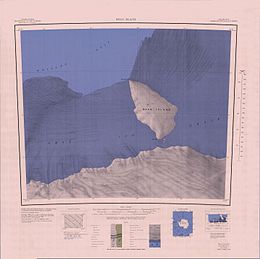
 1:250,000 scale topographic map of Dean Island. | |
 Dean Island Location in Antarctica | |
| Geography | |
|---|---|
| Location | Antarctica |
| Coordinates | 74°30′S 127°35′W |
| Area | 702 km2 (271 sq mi) |
| Length | 37 km (23 mi) |
| Width | 19 km (11.8 mi) |
| Administration | |
| Administered under the Antarctic Treaty System | |
| Demographics | |
| Population | Uninhabited |
See also
- Birdwell Point
- Cole Point
References
 This article incorporates public domain material from the United States Geological Survey document: "Dean Island (Antarctica)". (content from the Geographic Names Information System)
На других языках
[de] Dean-Insel
Die Dean-Insel ist eine 43 km lange, 22 km breite und ganzjährig vereiste Insel im Getz-Schelfeis vor der Küste des ostantarktischen Marie-Byrd-Land. Sie liegt zwischen der Grant-Insel und der Siple-Insel. Mit ihrem Nordkap Birdwell Point touchiert die Insel das offene Meer am Wrigley Gulf, einer Schelfeisbucht des unbenannten Randmeers des Südlichen Ozeans westlich der Amundsensee. Die Insel markiert die Grenze zwischen der Bakutis-Küste im Osten und der Hobbs-Küste im Westen.- [en] Dean Island (Antarctica)
[es] Isla Dean
La isla Dean es una isla antártica cubierta por el hielo. Tiene 37 km (20 millas náuticas) de largo y 19 km (10 millas náuticas) de ancho. Se encuentra próxima a la isla Grant y la isla Siple, en las costas de la Tierra de Marie Byrd, en la Antártida (74°42′S 127°05′O). La isla Dean no es reclamada por ningún país.[fr] Île Dean
L'île Dean est une île de l'océan Antarctique incluse dans la barrière de Getz à proximité de la côte septentrionale de la terre Marie Byrd[1]. Située à mi-chemin entre l'île Grant et l'île Siple, elle mesure 37 × 19 km. La pointe Cole, au sud de l'île, fait face à la terre Marie Byrd en marquant la limite entre la côte de Hobbs vers l'ouest et la côte de Bakutis vers l'est.Текст в блоке "Читать" взят с сайта "Википедия" и доступен по лицензии Creative Commons Attribution-ShareAlike; в отдельных случаях могут действовать дополнительные условия.
Другой контент может иметь иную лицензию. Перед использованием материалов сайта WikiSort.org внимательно изучите правила лицензирования конкретных элементов наполнения сайта.
Другой контент может иметь иную лицензию. Перед использованием материалов сайта WikiSort.org внимательно изучите правила лицензирования конкретных элементов наполнения сайта.
2019-2025
WikiSort.org - проект по пересортировке и дополнению контента Википедии
WikiSort.org - проект по пересортировке и дополнению контента Википедии