geo.wikisort.org - Island
Chrysi or Chrisi (Greek: Χρυσή, romanized: Chrysí, lit. 'golden'; also known as Gaidouronisi, Greek: Γαϊδουρονήσι, romanized: Gaïdouronísi, lit. 'donkey island') is an uninhabited Greek island approximately 15 kilometres (9 miles) south of Crete close to Ierapetra in the Libyan Sea.[1] Approximately 700 metres (2,300 feet) east of the island is the island of Mikronisi. Administratively these islands fall within the Ierapetra municipality in Lasithi.
Native name: Χρυσή | |
|---|---|
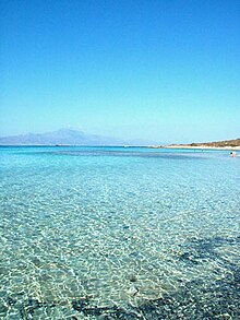
 A view of Crete from the island of Chrysi | |
 Chrissi | |
| Geography | |
| Coordinates | 34.87°N 25.71°E |
| Archipelago | Cretan Islands |
| Highest point | 31 |
| Administration | |
Greece | |
| Region | Crete |
| Regional unit | Lasithi |
| Demographics | |
| Population | 3 (2017) |

It contains a small harbour and church, the Church of Saint Nicholas, on its northwestern coast.
Tourism

It is possible to visit Chrissi by sea from Ierapetra and from Myrtos. There is a nudist beach on the north coast of the island. The highest point on the island is called Kefala ("Head") and it is 31 metres (102 feet) above sea level. On the western part of the island is the chapel of Saint Nicholas (estimated to date to the 13th century). There are also a salt pan, an old port, some Minoan ruins, a lighthouse and a Roman cemetery. Owing to the shallow waters around Chrissi, snorkelling and diving are popular pastimes. The Belegrina, Hatzivolakas, and Kataprosopo bays have a wide diversity of shells.
It is possible to reach the island from Ierapetra between middle of May and late October. During the summer months, excursion boats from Ierapetra leave the quay every morning and return in the afternoon.[2][3]
Environmental protection
Chrissi is protected as an "area of intense natural beauty". The island has the largest naturally formed Juniperus macrocarpa forest in Europe. There is no fresh drinking water on the island. The majority of trees have an average age of 200 years and average height of up to 7 metres (23 feet), some of the trees are up to 300 years old and 10 metres (33 feet) tall. The density is approximately 28 trees per hectare (69.16/acre).[4]
Archaeology
Archaeologists excavated a Minoan settlement dating to between 1800 and 1500 B.C. At the settlement they also found purple dye workshops and many artifacts.[5]
See also

References
- Isaakidou, Valasia; Tomkins, Peter (2008). Escaping the labyrinth: the Cretan neolithic in context. Oxbow Books. p. 218. ISBN 978-1-84217-291-9. Retrieved 5 June 2013.
- Pungetti, Gloria; Mannion, Antoinette M. (2008). Mediterranean Island Landscapes: Natural and Cultural Approaches. Springer. p. 65. ISBN 978-1-4020-5064-0. Retrieved 5 June 2013.
- Alexis Averbuck; Michael S Clark (1 May 2012). Lonely Planet Greek Islands. Lonely Planet. p. 356. ISBN 978-1-74321-078-9. Retrieved 5 June 2013.
- Natura 2000 site GR 4320003 Archived 2011-09-27 at the Wayback Machine (Greek)
- Minoan Purple Dye Workshops Excavated on Greek Island
External links
- Chrissi Island (English, Italian, Greek and auto translation options)
- Ierapetra Community, Island Chrysi (Greek)
- Chrissi Island (English)
На других языках
[de] Chrysi
Chrysi (griechisch Χρυσή (f. sg.) ‚die Goldene‘, auch Chrisi, Chrissi oder Chrissis) ist eine kleine unbewohnte griechische Insel im Libyschen Meer. Mit der nüchternen, unter Einheimischen verbreiteteren Bezeichnung Γαϊδαρονίσι (Gaidaronísi ‚Eselsinsel‘) ist die Insel auch auf einigen Karten vermerkt. Die etwa 5 km lange und 1 km breite Insel liegt etwa 15 km südlich der kretischen Stadt Ierapetra.- [en] Chrysi (island)
[fr] Chrysí
Chrysí (grec moderne : Χρυσή, « Dorée ») est une île inhabitée grecque située au sud de la Crète.[it] Chrysī
Chrysī (in greco: Χρυσή, "d'oro"), anche traslitterato come Chrissi, in alternativa, conosciuta come Gaidouronīsi (Γαϊδουρονήσι, "Isola dell'Asino"), è una piccola isola greca disabitata, a circa 15 km a sud di Creta in prossimità di Ierapetra, nel Mar Libico.[ru] Хриси (остров)
Хри́си[1] (греч. Χρυσή — «золотой»), также известен как Гайдурони́си[2] (греч. Γαϊδουρονήσι — «ослиный остров») — необитаемый остров в 20 км к югу от Иерапетры. Протяжённость острова — 5 км в длину и 1 км в ширину. Средняя высота над уровнем моря — 10 м. Наивысшая точка острова — 31 м над уровнем моря. В 700 метрах от Хриси лежит островок Микрониси (Μικρονήσι).Другой контент может иметь иную лицензию. Перед использованием материалов сайта WikiSort.org внимательно изучите правила лицензирования конкретных элементов наполнения сайта.
WikiSort.org - проект по пересортировке и дополнению контента Википедии