geo.wikisort.org - Island
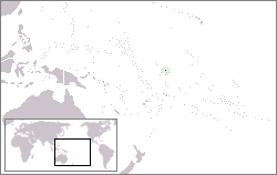
The Canton and Enderbury Islands consist of the coral atolls of Canton Island (also Kanton) and Enderbury in the northeastern part of the Phoenix Islands, about 1,850 miles (3,000 km) south of Hawaii in the central Pacific Ocean. The islands were vital naval and air bases on the route between the Americas and the Philippines and Australia and were claimed by both the United Kingdom and the United States.[1] From 1939 to 1979, they formed an Anglo–American condominium, with administration jointly exercised by the U.S. and the UK. This arrangement only covered Canton and Enderbury islands; the remaining Phoenix Islands were still claimed by the U.S. under the Guano Islands Act, but aside from Hull Island were either abandoned or remained under exclusive British control until 1979.[1]
Canton and Enderbury Islands | |||||||||
|---|---|---|---|---|---|---|---|---|---|
| 1939–1979 | |||||||||
  Flag | |||||||||
 Canton and Enderbury Islands | |||||||||
| Capital | Tebaronga | ||||||||
| Government | Condominium under the administration of the United States and the United Kingdom | ||||||||
| History | |||||||||
• Established | 6 April 1939 | ||||||||
• UK cession/ US evacuation | 12 July 1979 | ||||||||
| |||||||||
Both the UK and the U.S. claimed sovereignty over the islands since the mid–19th century. The official British claim was formally reasserted on 6 August 1936, and in March 1937 the islands were attached to its Gilbert and Ellice Islands Colony; establishing a radio station on Canton on 31 August 1937.[2] In June 1937 a spat occurred at Canton between USS Avocet and HMS Wellington and their crews. In response, on 26 July President Roosevelt approved a U.S. Navy plan to occupy Canton,[3] and on 3 March 1938 formally reasserted the United States claim, placing Canton and Enderbury under the control of the Department of the Interior.[4] Seven U.S. citizens from the American Equatorial Islands Colonization Project landed on Canton on 7 March.[5] To resolve these conflicting claims, the two governments signed an agreement on 6 April 1939 providing for joint administration over the islands without prejudice to the claims of either side.[6]
The United States and the United Kingdom relinquished control over the islands to the government of newly independent Kiribati; U.S. personnel left the island on 12 July 1979, the date of Kiribati's independence.[6][7] The Treaty of Tarawa, signed on 20 September 1979 and ratified by the United States Senate on 21 June 1983 and entered into force on 23 September 1983, formally relinquished U.S. claims over the former Canton and Enderbury Islands Condominium.[8] In this treaty, the U.S. acknowledged I-Kiribati sovereignty over fourteen islands, but reserved the right to military bases.[9] Today the islands form part of the Phoenix Islands administrative group within the Republic of Kiribati.
As of 2005, the population of Canton Island was 41, down from 61 in 2000.[10] In May 2010 the population was reportedly 24, with 14 adults and 10 children.[11] The island's sole village is called Tebaronga. Enderbury is uninhabited.
In 2006, the government of Kiribati declared the islands, together with other Phoenix Islands, to be a marine protected area, to preserve the unique flora and fauna of the archipelago and its surrounding waters.[12]
See also
References
- Resture, Jane. "Canton Island (Kanton – Abariringa) Phoenix Group, Kiribati". Jane Resture. Archived from the original on 5 April 2015. Retrieved 25 January 2015.
- "Foreign Relations of the United States Diplomatic Papers, 1937, The British Commonwealth, Europe, Near East and Africa, Volume II: 811.0141 Phoenix Group/16: Telegram". U.S. Department of State, Office of the Historian. Retrieved 24 October 2020.
- "United States Congressional Serial Set, Serial Number 13515: Senate Executive Reports, Nos. 1–20". United States Government Printing Office. 1984. pp. 47–49. Retrieved 24 October 2020.
- Felicity Caird (1987). "The Strategic Significance of the Pacific Islands in New Zealand's Defense Policy, 1935–1939" (PDF). University of Canterbury. pp. 64–65. Retrieved 24 October 2020.
- Claus–M. Naske (2004). "Ernest Gruening: Alaska's Greatest Governor". University of Alaska Press. Retrieved 24 October 2020.
- Marian Lloyd Nash (December 1983). "Digest of United States Practice in International Law 1979". US Department of State Office of the Legal Advisor. p. 783. Retrieved 24 October 2020.
- Peggy Ferris (29 May 1985). "The Kamehameha / Kiribati Connection: Project Panala'au in 50–Year Perspective, 1935–1985" (PDF). University of Hawaii. p. 25. Retrieved 24 October 2020.
- "Treaty of friendship between the United States of America and the Republic of Kiribati". Retrieved 2013-06-08.
Advise and consent to ratification by the Senate June 21, 1983;
- US Department of State Background Note
- "Kiribati 2005 Census of Population and Housing: Provisional Tables" (PDF). Government of Kiribati. 2005. Retrieved 9 May 2015.
- "Falmouth Coastguard helps starving remote islanders". National News. News Distribution Service. 9 May 2010. Archived from the original on 24 February 2012. Retrieved 9 May 2010.
- "Phoenix Islands Protected Area". Government of Kiribati. Archived from the original on 3 December 2019. Retrieved 25 January 2015.
| |
| |
| |
| |
| |
| |
| |
| |
|
На других языках
- [en] Canton and Enderbury Islands
[ru] Кантон и Эндербери
Острова́ Канто́н и Э́ндербери — с 1939 по 1979 года кондоминиум (совместное колониальное владение) Великобритании и США в Тихом океане. Располагался в северо-восточной части архипелага Феникс примерно в 3000 км к югу от Гавайских островов на одноимённых атоллах Кантон (или Абариринга) и Эндербери. В прошлом здесь располагались военно-морские и воздушные базы Великобритании и США. В 1979 году после получения независимости британской колонией Острова Гилберта стал частью Республики Кирибати.Другой контент может иметь иную лицензию. Перед использованием материалов сайта WikiSort.org внимательно изучите правила лицензирования конкретных элементов наполнения сайта.
WikiSort.org - проект по пересортировке и дополнению контента Википедии