geo.wikisort.org - Island
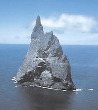
Ball's Pyramid is an erosional remnant of a shield volcano and caldera[1] lying 20 kilometres (12 mi) southeast of Lord Howe Island in the Pacific Ocean. It is 562 metres (1,844 ft) high, while measuring 1,100 metres (3,609 ft) in length and only 300 metres (984 ft) across, making it the tallest volcanic stack in the world.[2] Ball's Pyramid is part of the Lord Howe Island Marine Park in Australia and is over 643 kilometres (400 mi) northeast of Sydney, New South Wales.
| Ball's Pyramid | |
|---|---|
 Ball's Pyramid viewed from the surrounding waters | |
| Highest point | |
| Elevation | 562 m (1,844 ft) |
| Coordinates | 31°45′15″S 159°15′06″E |
| Geography | |
 Ball's Pyramid Location on a map of Oceania | |
| Location | Lord Howe Island Group, Australia |
| Parent range | Lord Howe Island Group |
| Geology | |
| Age of rock | < 7 million years |
| Mountain type | Volcanic plug |
| Volcanic arc/belt | Lord Howe Seamount Chain |
| Last eruption | Unknown |
| Climbing | |
| First ascent | 1965 |
Steep, eroded, and formed 6.4 million years ago,[1] Ball's Pyramid is positioned in the centre of a submarine shelf and is surrounded by rough seas, making any approach difficult.[1]
History
Discovery

The pyramid is named after Royal Navy Lieutenant Henry Lidgbird Ball, who reported discovering it in 1788. On the same voyage, Ball also reported discovering Lord Howe Island.
In The Voyage of Governor Phillip to Botany Bay with an Account of the Establishment of the Colonies of Port Jackson and Norfolk Island (1789), Arthur Phillip gives this description of the area around Ball's Pyramid.. before describing Lord Howe Island:
There lies about four miles from the south-west part of the pyramid, a dangerous rock, which shows itself a little above the surface of the water, and appears not to be larger than a boat. Lieutenant Ball had no opportunity of examining whether there is a safe passage between them or not.[3]
Survey and exploration

In May 1853, Henry Mangles Denham with HMS Herald and HMS Torch surveyed the area around Lord Howe Island including Ball's Pyramid, producing the first chart of the pyramid.[4]
The first recorded person to go ashore is believed to have been Henry Wilkinson, a geologist at the New South Wales Department of Mines, in 1882.
In 1964, a team from Sydney attempted to climb to the summit of the pyramid. However, the climbers were forced to turn back on the fifth day as they ran short of food and water. The expedition was the idea of Australian adventurer Dick Smith, who was a member of Rover Scouts at the time. The expedition also involved other members of the Scouting movement and other people. Smith went on the expedition, but did not attempt the climb due to an unexpected medical operation two weeks before the expedition.
Ball's Pyramid was first climbed on 14 February 1965 by Bryden Allen, John Davis, Jack Pettigrew and David Witham of the Sydney Rock Climbing Club. Jack Hill of New Zealand then climbed to the summit with Pettigrew on the following day. Don Willcox and Ben Sandilands were part of the support team.[5]
In 1979, Smith returned to the pyramid, together with climbers John Worrall and Hugh Ward. They successfully reached the summit and unfurled a flag of New South Wales provided to them by Premier Neville Wran.
Climbing was banned in 1982 under amendments to the Lord Howe Island Act, and in 1986, all access to the island was banned by the Lord Howe Island Board. In 1990, the policy was relaxed to allow some climbing under strict conditions, which in recent years has required an application to the relevant state minister.[6]
Geography
Like Lord Howe Island and the Lord Howe Seamount Chain, Ball's Pyramid is based on the Lord Howe Rise, part of the submerged continent of Zealandia. Ball's Pyramid has a few satellite islets. Observatory Rock and Wheatsheaf Islet lie about 800 metres (2,600 ft) west-northwest and west-southwest respectively, of the western extremity of Ball's Pyramid. Southeast Rock is a pinnacle located about 3.5 kilometres (2.2 mi) southeast of Ball's Pyramid.
The shelf is 20 kilometres (12 mi) in length and averages 10 kilometres (6.2 mi) in width and lies under an average depth of 50 metres (160 ft) of water.[1] It is separated by a 500-metre-deep (1,600 ft) submarine canyon from another shelf on which Lord Howe Island is located. The cliffs of the stack continue under the water surface to the level of the shelf.
Flora and fauna
Melaleuca howeana
A Melaleuca howeana shrub was found growing on Ball's Pyramid. The bush was growing in a small crevice where water was seeping through cracks in the underlying rocks. This moisture supported relatively lush plant growth which had, over time, resulted in a buildup of plant debris several metres deep.[7]
Dryococelus australis
Ball's Pyramid supports the last known wild population of Lord Howe Island stick insect (Dryococelus australis).[8]
Following the last sighting of the Lord Howe Island stick insect on Lord Howe Island in 1920, the species was presumed extinct. Evidence of continued survival on Ball's Pyramid was discovered during the 1964 climb when a dead specimen was found and photographed. Throughout the following years, several more dead specimens were discovered, but attempts to find live specimens were unsuccessful.[9]
In 2001, a team of entomologists and conservationists landed on Ball's Pyramid to chart its flora and fauna. As they had hoped, they discovered a population of the Lord Howe Island stick insect living in an area of 6 by 30 metres (20 by 100 ft), at a height of 100 metres (330 ft) above the shoreline, under a single M. howeana shrub. The population was extremely small, with only 24 individuals. Two pairs were brought to mainland Australia, and new populations have been successfully bred[10] with the ultimate goal of reintroduction to Lord Howe Island.
In 2014 an unauthorised climbing team sighted live stick insects in an exposed position 65 metres (213 ft) below the summit of Ball's Pyramid in a thicket of sedge plants, suggesting that the insect's range on Ball's Pyramid is more widespread than previously held and its food preferences are not limited to Melaleuca howeana.[11][12]
See also
References
- Woodroffe, Colin (29 May 2012). "Balls Pyramid and the efficacy of marine abrasion". Vignettes. Carleton College. Retrieved 9 July 2013.
- Geography and Geology Archived 12 September 2014 at the Wayback Machine, Lord Howe Island Tourism Association. Retrieved on 2009-04-20.
- Philip, Arthur (1789). The Voyage of Governor Phillip to Botany Bay with an Account of the Establishment of the Colonies of Port Jackson and Norfolk Island. Piccadilly, London: John Stockdale. Retrieved 9 April 2014.
- David, Andrew (1995). The Voyage of HMS Herald. Melbourne University Press. pp. 29–30. ISBN 0-522-84390--5.
- Bryden Allen's climbing page (University of Queensland)
- Mr Andrew Fraser (Coffs Harbour) Archived 2007-09-29 at the Wayback Machine in the New South Wales Legislative Assembly, 1 May 1996
- "Lord Howe Island: Return of the tree lobster". GeoCurrents. Retrieved 9 September 2022.
- Krulwich, Robert (29 February 2012). "Six Legged Giant Finds Secret Hideaway for 80 years". National Public Radio. Retrieved 18 January 2016.
- Smith, Jim (2016). South Pacific Pinnacle, The exploration of Ball's Pyramid. Den Fenella press. ISBN 978-0-9943872-0-2
- Thomas, Abbie (14 February 2001). "Giant stick insect rediscovered". Australian Broadcasting Corporation.
- Smith, Jim (2016). South Pacific Pinnacle, The exploration of Ball's Pyramid. Den Fenella press. ISBN 978-0-9943872-0-2
- Smith, Dick (2015). Balls Pyramid, Climbing the world's tallest sea stack. Dick Smith Adventure Pty Ltd. ISBN 978-0-646-94603-0
Further reading
- Hutton, Ian (1998). The Australian Geographic Book of Lord Howe Island. Australian Geographic. ISBN 1-876276-27-4.
- "Rock of Ages", transcript of Australian Broadcasting Corporation Australian Story TV episode, 11 April 2005.
External links
- "Lord Howe Island Marine Park". Marine Parks. Parks Australia.
- "Lord Howe Island and Ball's Pyramid". Nautical Chart. Australian Hydrographic Service. Archived from the original on 8 December 2012.
- "Ball's Pyramid". Peakware.com. Archived from the original on 4 March 2016.
- "Balls Pyramid". Volcano World.
- Allen, Bryden. "Mountaineering exploits: Ball's Pyramid". University of Queensland.
На других языках
[de] Ball’s Pyramid
Ball’s Pyramid ist eine unbewohnte Felsinsel in Form eines Brandungspfeilers, die etwa 600 Kilometer östlich des australischen Festlandes in der Tasmansee liegt. Sie gehört zur australischen Lord-Howe-Inselgruppe und liegt rund 20 Kilometer südöstlich der Lord-Howe-Insel, der Hauptinsel der Gruppe.- [en] Ball's Pyramid
[es] Pirámide de Ball
La pirámide de Ball es un islote deshabitado localizado en medio del océano Pacífico, un resto de la erosión de un antiguo volcán en escudo y la caldera que se formó hace 7 millones de años. Está situada a 20 km (13 millas) al sureste de la isla de Lord Howe. Tiene una altitud de 562 m, y únicamente 300 de largo. Está situada a 31°45′21″S 159°15′02″E. Forma parte del parque marino de la Isla de Lord Howe.[fr] Pyramide de Ball
La pyramide de Ball, en anglais Ball's Pyramid, est une île australienne située dans la mer de Tasman, au sud-est de l'île Lord Howe[1]. Il s'agit d'un neck, les restes érodés d'une cheminée volcanique, culminant à 562 mètres d'altitude[1], d'une longueur d'environ 1100 mètres sur 200 mètres de large.[it] Piramide di Ball
La Piramide di Ball (in inglese: Ball's Pyramid) è il faraglione più alto del mondo. Si trova nel Mar di Tasmania (nell'Oceano Pacifico) e dal punto di vista politico appartiene all'Australia. È il neck di un antico vulcano la cui caldera si formò circa 7 milioni di anni fa. Fa parte del continente sommerso della Zealandia di cui la Nuova Zelanda è la parte emersa più visibile. L'isola, disabitata, è alta 562 metri e si trova al largo dell'isola di Lord Howe, facente parte dello Stato australiano del Nuovo Galles del Sud. Su uno dei pochissimi cespugli esistenti sulla Piramide di Ball è stato ritrovato un insetto ritenuto ormai scomparso, la cosiddetta aragosta di terra (in realtà è un insetto "stecco", un fasmide il cui nome scientifico è Dryococelus australis).[ru] Болс-Пирамид
Болс-Пи́рамид (англ. Ball's Pyramid) — необитаемый вулканический остров в Тасмановом море, приблизительно в 20 километрах к юго-востоку от острова Лорд-Хау, вместе с которым был открыт в 1788 году. Внешне остров напоминает парус или пирамиду. Болс-Пирамид является самым высоким вулканическим утёсом на Земле[1][2].Другой контент может иметь иную лицензию. Перед использованием материалов сайта WikiSort.org внимательно изучите правила лицензирования конкретных элементов наполнения сайта.
WikiSort.org - проект по пересортировке и дополнению контента Википедии