geo.wikisort.org - Island
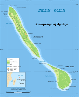
Agaléga (French: îles Agaléga) is a dependency of Mauritius which consists of two outer islands located in the Indian Ocean, about 1,000 kilometres (620 mi) north of Mauritius Island. The population of the islands as at July 2011 was estimated at 289.[1] The islands have a total area of 2,600 ha (6,400 acres). The North island is 12.5 km (7.8 mi) long and 1.5 km (0.9 mi) wide, while the South island is 7 km (4.3 mi) long and 4.5 km (2.8 mi) wide. The North Island is home to the islands' airstrip and the capital Vingt-Cinq.[2] The islands are known for their coconuts, the production of which is their main industry, and for the Agalega day gecko.
This article needs additional citations for verification. (February 2017) |
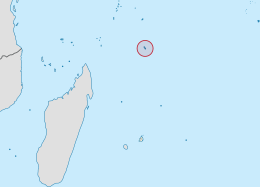 Location of the Agalega Islands in the Indian Ocean. | |
 | |
| Geography | |
|---|---|
| Location | Indian Ocean |
| Coordinates | 10°25′S 56°35′E |
| Total islands | 2 |
| Area | 24 km2 (9.3 sq mi) |
| Administration | |
| Dependency | Agaléga |
| Largest settlement | Vingt-Cinq |
| Demographics | |
| Population | 289 (2011) |
| Pop. density | 12/km2 (31/sq mi) |
| Ethnic groups | Creole |
There is a Memorandum of Understanding between the Government of Mauritius and the Government of India to develop the Agaléga islands and allowing India to set up a military base there[3][4][5][6] (see India–Mauritius military cooperation). Local residents are unhappy and protesting over construction of the military base which is raising issues of unemployment, culture and Mauritian sovereignty.[7][8]
Etymology
There are three different explanations for the name Agaléga. One hypothesis is that the Portuguese explorer, Dom Pedro Mascarenhas, named Agaléga and the island of Sainte Marie (off the east coast of Madagascar) in honor of his two sailboats, the "Galega" and the "Santa Maria" in 1512, when he discovered Mauritius and Réunion Island.
Another, more probable explanation relates to the Galician explorer João da Nova, who discovered the islands in 1501 while working for the Portuguese. João was popularly known by his sailors as João Galego, according to Jean-Baptiste Benoît Eyriès' Les Nouvelles Annales de Voyage (Volume 38, page 88). Galego is the Galician/Portuguese word for someone from Galicia, North West Spain, and "Agalega", is derived from the feminine version of this (a is the feminine article in Galician/Portuguese, and Galician illa for "island" is feminine, so a [illa] galega would mean "the Galician [Island]").
A further idea comes from a story in Sir Robert Scott's book Limuria: The Lesser Dependencies of Mauritius, where he describes the 1509 discovery of the Islands by the Portuguese mariner Diogo Lopes de Sequeira. According to this version, Diogo named the Islands Baixas da Gale, with the "da Gale" referring to putative gale-force winds hypothetically modelling the coasts of both islands. Scott suggests that maps of the region represented the islands initially as Gale, metamorphosing into Galera, Galega and finally Agalega.
Agale 1519 Atlas Miller, Pedro Reiner [1]https://gallica.bnf.fr/ark:/12148/btv1b55002605w/f2.item#
Gale 1519 Carte du Monde Jorge Reinel, Sevilla [2]https://gallica.bnf.fr/ark:/12148/btv1b59055673/f1.item
Y. de la Gale 1525 Planisfero Castiglioni: Carta del navigare universalissima et dil. gentilissima, Sevilla [3]https://edl.beniculturali.it/beu/850013656
Y. de la Galera 1548 Africa Nova tabula Gioan. Gastaldi, Giacomo; Pietro Andrea, Pb. Baptista Pedrezano Venecia [4]https://www.davidrumsey.com/luna/servlet/detail/RUMSEY~8~1~291327~90063055
Y. de la galera 1570 Ortelius, Abraham, 1527-1598 Africae Tabula Nova.Pb. Gielis Coppens van Diest; Anberes [5]
Agalega 1587 Tavola XVI. Che Ha Sua Superiore La Tavola Settima. Libro Terzo. Monte (Monti), Urbano, 1544-1613 Manuscript [6]
Da Galega 1595 Indian Ocean. Delineatio Orarum maritimarum, Terra vulgo indigetata Terra do Naral, item Sofale, Mozambicae ....Linschoten, Jan Huygen van, 1563-1611Paludanus, Bernard, 1550-1633 Chez Evert Pb. Cloppenburgh, Amsterdam [7]
Y. de la Galera 1599 Africa Nuova tavola, Ruscelli, Girolamo; Rosaccio, Giuseppe; Appresso gli heredi di Melchior Sessa; Venecia [8]
I. du Gallega: 1607 "Abissinorum Sive Pretiosi Ioannis Imperiu" Cornelis Claes, Amsterdam [9]
I. d. Gale 1665 Blaeu, Joan, 1596-1673 Africae nova descriptio Pb Joan Blaeu, Amsterdam [10]
History

As with the Mascarene islands, they may have been known to Arab and Malay sailors, although no written records have been found to confirm this. Agalega, or Galega, was examined by Captain Briggs of HMS Clorinde, on the 12th of January, 1811, who seems to have fixed its situation correctly, which was previously not well ascertained. The landing was found difficult on account of the heavy surf, the island being surrounded by a reef. A person who formerly had commanded a French privateer, was at this time settled on the island, having under him a colony of negroes (sic), who cultivated part of the ground[9] with maize and wheat.
The first settlement on the islands was founded by M. de Rosemond. Upon his arrival in August 1808, he discovered the bodies of two castaways and a bottle containing notes written by one of them, the privateer Robert Dufour. The only mountain on the islands, Montagne d'Emmerez (in reality no more than a hill), derives its name from the second wrecked sailor, Adelaide d'Emmerez, a Mauritian.
Economic, infrastructural and political development of the islands didn't begin until the arrival of Auguste Le Duc in 1827, a French administrator sent by M. Barbé to organise production of coconut oil and copra. There still exists a number of historical monuments dating from the period 1827 to 1846, made by slaves: the village Vingt-Cinq (named after the 25 lashes that were given to rebellious slaves), the Slave Dungeons, an Oil Mill, a cemetery for Blacks and a cemetery for Whites, among others. Auguste Le Duc also began construction of a bridge between the two islands, although it was swept away by severe weather.
Father Victor Malaval brought the Catholic Church to the islands in 1897 as the first missionary. An improvised chapel was built on the South Island.
The origin of inhabitants has been highly influenced by the political situation in the world in the nineteenth century (Mauritius, which passed to the English in 1810, the abolition of the slave trade, abolition of slavery in 1835, and the arrival of unskilled Asian labourers. The slaves themselves were of Malagasy origin, or from Madras in India, while some were freed from slaving ships while others were from the trading ports of the Comoros Islands.
Legends such as "Calèche Blanc" and "Princesse Malgache" are part of the folklore of the islands, as well as the coded language of "Madam langaz Seret" which has come down from the time of slaves. This language is a mixture of French and Mauritian Creole where every syllable is doubled with the first consonants replaced by the "g" (e.g. "Français" becomes "frangrançaisgais"). The origin and purpose of this language remains unclear.
Today, the population consists of around 300 people, known locally as Agaléens, who speak Creole. Catholicism is the dominant religion.
Geography
North Island is 12.5 kilometres (7.8 miles) long and 1.5 kilometres (0.9 miles) wide while South Island is 7 kilometres (4.3 miles) long and 4.5 kilometres (2.8 miles) wide. The total area of both islands is 26 square kilometres (10 square miles). The soil is likely coral. The culmination is at the top of the hill Emmer on the island in the north. The climate is hot and humid and the average annual temperature is 26 °C (79 °F), ranging from a minimum of 22.5 °C (72.5 °F) and a maximum of 30.6 °C (87.1 °F). April is the hottest month of the year. The tropical climate is conducive to the development of mangrove and coconut trees that cover the two islets.
Economy
Agaléga is managed by a company of the State of Mauritius, the Outer Island Development Company (OIDC),[10][citation needed] a company which develops remote islands. The company delegates a Resident Manager, a kind of steward, who is the supreme authority on the two islets. The economy of the archipelago is based primarily on the exportation of coconut oil.
Infrastructure
Most homes are in the main villages of Vingt-Cinq and La Fourche on the North Island, and St. Rita on the South Island. The road connecting the different localities is sandy and coral. The North Island is home to an airstrip, a government primary school "Jacques Le Chartier", the police station, the weather station, the central telecommunications office (Mauritius Telecom) and the health service. There is no running water on the island. Drinking water comes from rainwater collected by gutters. Water for other uses is sourced from wells. Electricity is supplied by generators running on diesel, with supply limited to certain hours. The company that manages the remote islands, such as Agaléga and St Brandon, is working on a project to ensure power supply to these islands, via submarine connection.[citation needed]
Agaléga is connected to Mauritius by air and sea. The older airstrip on the island in the north allows takeoff and landing of small aircraft. There is now a new 10,000 foot long modern airstrip suitable for jet aircraft.[11] There is no functional port on the islands, only a pier at St James Anchorage on the island's north. Vessels of the Mauritius Shipping Corporation (the Pride Mauritius and the Mauritius Trochetia) cast anchor about 500 metres (1,600 feet) from this place, in the deep sea, during refueling.[citation needed]
Health services are provided by a health officer and a midwife. Doctors from Mauritius make short tours throughout the year. The Agaléens also receive a visit from a magistrate during the year.[citation needed]
For education, there is a primary school for the young, but pupils then continue their education in secondary schools on the island of Mauritius.[citation needed]
References
- "Geography − location". Government of Mauritius. Archived from the original on 2012-11-14. Retrieved 25 July 2012.
- "About Agalega". Government of Mauritius. Archived from the original on 2012-09-19. Retrieved 25 July 2012.
- "Republic of Mauritius- Development of Agalega – No Lease Agreement contained in MOU signed with India, says Minister Koonjoo". www.govmu.org. Retrieved 2021-05-19.
- "India to develop strategic assets in 2 Mauritius, Seychelles islands.", Indian Express, 12 March 2015.
- "Naval muscle should fetch economic returns.", The Tribune, 20 March 2015.
- "India: Building a Sphere of Influence in the Indian Ocean? - RealClearDefense".
- "Agaléga islanders fear for future due to secret Indian navy base". Al Jazeera. Retrieved 4 August 2021.
- Greene, Andrew. "India building secretive base in Mauritius as it strengthens military ties with Australia". ABC News. Retrieved 4 August 2021.
- India Directory 1826[full citation needed]
- The Outer Islands Development Corporation (OIDC) Act No. 41 of 1982
- New Indian Express:Aug 3rd, 2021: India believed to be building naval facility on Mauritian island of Agalega
External links
Islands of Mauritius | |||||
|---|---|---|---|---|---|
| Outer Islands |  | ||||
| Islets |
| ||||
| Fishing banks |
| ||||
| Claims/Disputed |
| ||||
Mauritius articles | ||||||||||||||
|---|---|---|---|---|---|---|---|---|---|---|---|---|---|---|
| ||||||||||||||
| Subdivisions |
|  | ||||||||||||
| Politics |
| |||||||||||||
| Economy |
| |||||||||||||
| Society |
| |||||||||||||
| ||||||||||||||
| Authority control |
|
|---|
На других языках
[de] Agalega-Inseln
Die Agalega-Inseln sind eine aus zwei Inseln bestehende Gruppe im Indischen Ozean. Politisch gehören sie zu Mauritius, obwohl sie 1100 km nördlich der Insel Mauritius und damit näher an Madagaskar oder zu den Seychellen liegen.- [en] Agaléga
[es] Islas Agalega
Las islas Agalega (îles Agaléga, en francés) son dos islas localizadas en el océano Índico, a unos 1100 km al norte de la isla Mauricio. En julio de 2011, la población de las islas se estimó en 300 habitantes.[1][it] Agalega
Le isole Agalega sono due isole (isola Nord e isola Sud) dell'Oceano indiano, a 1.100 km a nord di Mauritius a cui appartengono.[ru] Агалега
Агале́га[1][2] (фр. Agaléga) — острова в западной части Индийского океана (о. Северный и о. Южный); расположены в 800 км к северо-востоку от Мадагаскара и в 1100 км к северу от острова Маврикий[3]. Администрируются как Внешние острова Маврикия.Другой контент может иметь иную лицензию. Перед использованием материалов сайта WikiSort.org внимательно изучите правила лицензирования конкретных элементов наполнения сайта.
WikiSort.org - проект по пересортировке и дополнению контента Википедии