geo.wikisort.org - Insel
Die Islands of Four Mountains sind eine Inselgruppe in den Alëuten im US-Bundesstaat Alaska.
| Islands of Four Mountains | ||
|---|---|---|
 | ||
| Gewässer | Pazifischer Ozean | |
| Archipel | Aleuten | |
| Geographische Lage | 52° 52′ N, 169° 48′ W | |
| ||
| Anzahl der Inseln | 7 | |
| Hauptinsel | Yunaska Island | |
| Gesamte Landfläche | 545,596 km² | |
| Einwohner | unbewohnt | |
 | ||

Geographie
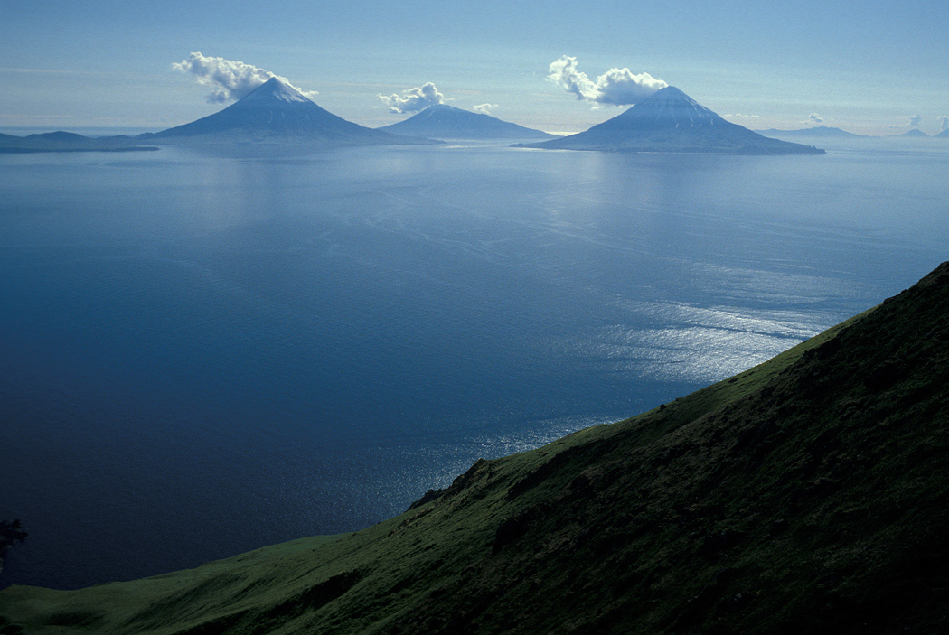
In der über 80 Kilometer langen Inselkette liegen zwischen den Andreanof Islands im Westen und den Fox Islands im Osten Amukta Island, Chagulak Island, Yunaska Island (173 km²), Herbert Island, Carlisle Island, Chuginadak Island (167 km²), Uliaga Island sowie Kagamil Island. Sie wird von den Meeresstraßen Amukta Pass und Samalga Pass im Westen und Osten begrenzt.
Die Inseln haben eine Gesamtfläche von 545,596 km² und sind nicht ganzjährig bewohnt.[1]
Geschichte
Die Aleuten, die diese Inseln schon seit 5000 Jahren bewohnten, nannten sie „Unigun“ (deutsch: „Geburtsort der Winde“), denn heulende Stürme sind hier keine Seltenheit. Die Aleuten betrachteten diese Inseln, besonders Kagamil Island, als den Ursprungsort ihres Volkes. Sie begruben ihre Toten hier, mumifiziert, was auf die spirituelle Bedeutung dieses Ortes hinweist.
Aufgrund der vier bedeutenden Vulkane Mount Cleveland, Mount Carlisle, Mount Kagamil und Mount Herbert tauften die russischen Forscher diese Inseln „Inseln der vier Hügel“ (russisch четырехсопочные острова, tschetyrjechsopotschnye ostrowa).
Der heutige Name wurde 1894 auf der USS Concord kreiert und 1895 durch das U.S. Navy Hydrography Office (Chart 8) publiziert.[2]
Fauna
Auf den Islands of Four Mountains brüten unter anderem Bartalken, nach dem Zwergalk der kleinste der Alkenvögel.[3]
Weblinks
- Luftaufnahme (Memento vom 23. Dezember 2010 im Internet Archive)
Einzelnachweise
- Islands of Four Mountains: Blocks 1080 thru 1082, Census Tract 1, Aleutians West Census Area, Alaska United States Census Bureau, 2000
- Islands of Four Mountains im Geographic Names Information System des United States Geological Survey
- Anthony J. Gaston und Ian L. Jones: The Auks. Oxford University Press, Oxford 1998, ISBN 0-19-854032-9, S. 263
На других языках
- [de] Islands of Four Mountains
[en] Islands of Four Mountains
Islands of Four Mountains (Russian: Четырёхсопочные острова) is an island grouping of the Aleutian Islands in Alaska, United States. The chain includes, from west to east, Amukta, Chagulak, Yunaska, Herbert, Carlisle, Chuginadak, Uliaga, and Kagamil islands.[1] This island chain is located between Amukta Pass and the Andreanof Islands to the west, and Samalga Pass and the Fox Islands to the east. These islands have a total land area of 210.656 sq mi (545.596 km2) and have no permanent population.[2] The two largest islands are Yunaska and Chuginadak. Chuginadak is mainly made up of the active volcano Mount Cleveland.[3][es] Islas de los Cuatro Volcanes
Las islas de los Cuatro Volcanes (en inglés: 'Islands of Four Mountains') son un grupo de pequeñas islas de Estados Unidos localizadas en la parte central del archipiélago de las islas Aleutianas. Administrativamente, pertenecen al Área censal de Aleutians West de estado de Alaska.[fr] Îles des Quatre-Montagnes
Les îles des Quatre-Montagnes sont un groupe d'îles de l'archipel des Aléoutiennes dans le sud-ouest de l'Alaska (États-Unis).[it] Isole Four Mountains
Le isole Four Mountains, o isole Quattro Montagne, sono un gruppo di isole che fanno parte dell'arcipelago delle Aleutine e appartengono all'Alaska (USA). Si trovano tra lo stretto Amukta e le isole Andreanof ad ovest, e lo stretto Samalga e le isole Fox ad est. Si compongono di 7 isole (in ordine da ovest ad est):[ru] Четырёхсопочные острова
Четырёхсопочные острова (англ. Islands of Four Mountains) — группа островов в восточной части цепи Алеутских островов. Граничит с морскими путями и расположена между проливом Амукта и Андреяновскими островами на западе, а также между проливом Самалга и Лисьими островами на востоке. Административно острова относятся к американскому штату Аляска.Другой контент может иметь иную лицензию. Перед использованием материалов сайта WikiSort.org внимательно изучите правила лицензирования конкретных элементов наполнения сайта.
WikiSort.org - проект по пересортировке и дополнению контента Википедии