geo.wikisort.org - Insel
Die Cargados-Carajos-Inseln (englisch Cargados Carajos Shoals) auch Saint Brandon sind eine Inselgruppe mit einem ausgedehnten Riff im Indischen Ozean, 407 Kilometer (Coco Island – Mauritius) nordöstlich von Mauritius (Coco Island – Port Louis 431 km). Sie liegen auf dem unterseeischen Maskarenen-Plateau und sind somit Teil der Inselgruppe der Maskarenen.
| Cargados-Carajos-Inseln | |
|---|---|
 | |
| Gewässer | Indischer Ozean |
| Archipel | Maskarenen |
| Geographische Lage | 16° 35′ S, 59° 37′ O |
 | |
| Anzahl der Inseln | 22 |
| Hauptinsel | Île Raphael |
| Gesamte Landfläche | 3,2 km² |
| Einwohner | unbewohnt |
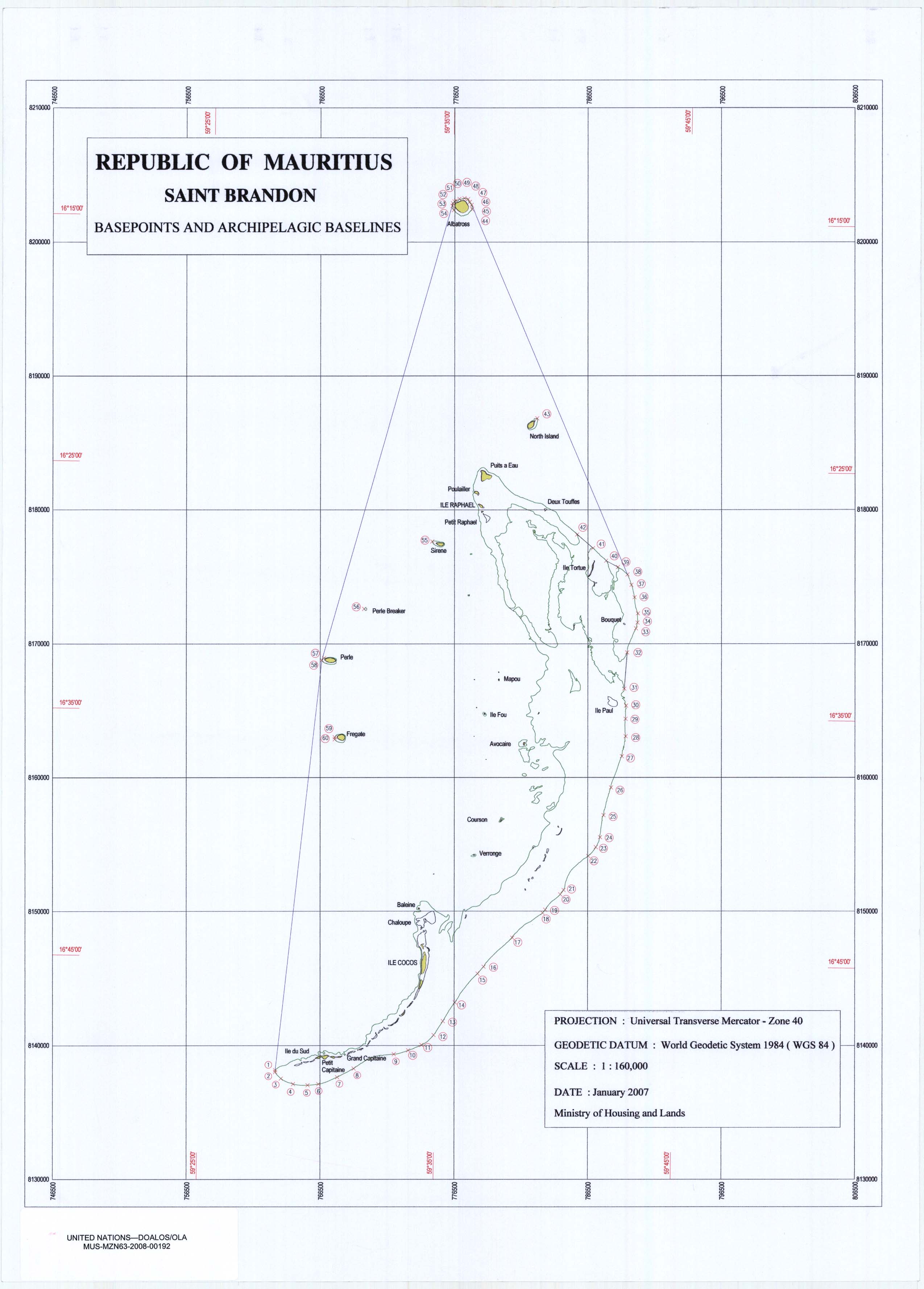
Ihre Landfläche beträgt nur rund 3,2 km², das Riff erstreckt sich auf 65,5 km in Nord-Süd-Richtung bei einer Breite von rund 21 km, bedeckt also eine Fläche von etwa 1.356 km². Fast alle Inseln erheben sich westlich dieses Riffs aus dem Meer. Sie bilden die Reste eines untergegangenen Vulkans.
Politisch sind die Cargados-Carajos-Inseln ein von Mauritius abhängiges Gebiet und werden direkt von der Regierung in Port Louis verwaltet. Der Zensus im Jahr 2000 weist für die Inselgruppe keine permanente Bevölkerung aus, jedoch hielten sich zum Zeitpunkt des Zensus 63 Personen auf Cargados Carajos auf.[1] Die Inseln werden als Fischerei-Stützpunkt genutzt, der Abbau von Guano und die Kopra-Produktion sind weitere Erwerbsquellen. Die Inseln sind mit Korallensand bedeckt, an vielen Stellen findet sich eine dicke Schicht Guano. Meeresschildkröten nutzen die Strände zur Eiablage.
Die Inselgruppe wurde vermutlich schon von arabischen Seeleuten im 7. Jahrhundert entdeckt. Sie erhielt ihren Namen 1506 von portugiesischen Seefahrern auf dem Weg nach Indien. 1598 wurden die Inseln von den Niederländern erobert, 1722 französisches Protektorat, gelangten 1810 in britische Hand und wurden 1968 Teil des unabhängigen Mauritius.
Auf der zweiten Etappe des Volvo Ocean Race 2014–2015 lief das Team Vestas Wind am 29. November 2014 auf ein Riff der Cargados-Carajos-Inseln auf.[2] Die Mannschaft konnte unverletzt gerettet werden.
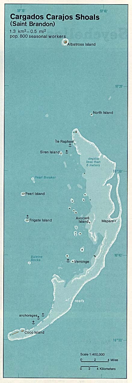
Die größeren Inseln
Die folgende Tabelle listet die größeren Inseln nach ihrer geographischen Lage (von Nord nach Süd).
| Name | Lage | Bemerkungen |
|---|---|---|
| Albatross Island | 16°13'43"S, 59°35'15"E | Fläche 1,01 km², mit 6 m ü. d. Meeresspiegel höchste Erhebung, seit 1988 unbewohnt |
| Îlot du Nord (North Island) | 16°19S, 59°39'E | |
| Île Raphael | 16°27'S, 59°37'E | größte Bevölkerung (> 35); Fischerei, Wetterstation, Küstenwache |
| Îlot Siren | 16°28'S, 59°34'E | |
| Ile Tortue | 16°28'S, 59°41'E | |
| Pearl Islet (Île Perle) | 16°31'S, 59°32'E | |
| Île du Sud | 16°32'S, 59°32'E | einige temporäre Einwohner |
| Avocare Island (Avoquer) | 16°35'S, 59°40'E | einige temporäre Einwohner |
| Mapare Islet | 16°35'S, 59°41'E | |
| Frigate Islet (Île Frégate) | 16°37'S, 59°31'E | |
| Îlote du Paul | 16°37'S, 59°33'E | |
| Baleine Rocks | 16°41'S, 59°30'E | |
| Île Veronge (Verronge) | 16°41'S, 59°37'E | |
| Veronge Îlot | 16°42'S, 59°38'E | |
| Palm Islet | 16°45'S, 59°35'E | |
| Coco Island (Île aux Cocos) | 16°48'07"S, 59°32'44"E | einige temporäre Einwohner, Wetterstation |
| Grande Capitane | 16°40'S, 59°50'E | |
| Petite Capitane | 16°36'S, 59°34'E | |
| Puits A Eau | 16°39'S, 59°34'E | |
| Ile Poulailer | 16°44'S, 59°46'E | |
| Chaloupe | 16°49'S, 59°50'E | |
| Courson | 16°48'S, 59°30'E |
Klimatabelle
| St. Brandon (Cargados-Carajos-Inseln) | ||||||||||||||||||||||||||||||||||||||||||||||||
|---|---|---|---|---|---|---|---|---|---|---|---|---|---|---|---|---|---|---|---|---|---|---|---|---|---|---|---|---|---|---|---|---|---|---|---|---|---|---|---|---|---|---|---|---|---|---|---|---|
| Klimadiagramm | ||||||||||||||||||||||||||||||||||||||||||||||||
| ||||||||||||||||||||||||||||||||||||||||||||||||
|
Monatliche Durchschnittstemperaturen und -niederschläge für St. Brandon (Cargados-Carajos-Inseln)
Quelle: wetterkontor.de | |||||||||||||||||||||||||||||||||||||||||||||||||||||||||||||||||||||||||||||||||||||||||||||||||||||||||||||||||||||||||||||||||||||||
Einzelnachweise
- Mauritius Census 2000 (Memento vom 21. November 2009 im Internet Archive) (englisch)
- Grounded. In: Volvo Ocean Race official website . Archiviert vom Original am 5. Dezember 2014. Info: Der Archivlink wurde automatisch eingesetzt und noch nicht geprüft. Bitte prüfe Original- und Archivlink gemäß Anleitung und entferne dann diesen Hinweis. Abgerufen am 30. November 2014. (englisch)
Weblinks
Distrikte:
Black River |
Flacq |
Grand Port |
Moka |
Pamplemousses |
Plaines Wilhems |
Port Louis (Distrikt) |
Rivière du Rempart |
Savanne
Städte:
Beau Bassin-Rose Hill |
Curepipe |
Port Louis (Stadt) |
Quatre Bornes |
Vacoas-Phoenix
Abhängige Inseln:
Agalega |
Cargados Carajos |
Rodrigues
На других языках
- [de] Cargados-Carajos-Inseln
[en] St. Brandon
Saint Brandon, also known as the Cargados Carajos Shoals, is an Indian Ocean archipelago about 430 kilometres (270 mi) northeast of Mauritius consisting of a number of sand banks, shoals and islets. Saint Brandon consists of five island groups, with about 28–40 islands and islets in total, depending on seasonal storms and related sand movements.[1] There are 22 named islands and shoals. The archipelago is low-lying and is prone to substantial submersion in severe weather.[citation needed] It has an aggregate land area estimated variously at 1.3 km2 (0.50 sq mi) and 500 acres (2.0 km2).[1] Economic activity in the region is limited to fishing on the very extensive shallow bank covering approximately 900 sq mi (2,300 km2) around the islands. By the early 19th century, most of the islands were in use as fishing stations. Geographically, the archipelago is part of the Mascarene Islands and is situated on the Mascarene Plateau formed by the separation of the Mauritia microcontinent during the separation of India and Madagascar about 60 million years ago.[es] Cargados Carajos
El banco de Cargados Carajos (también conocidos como las Rocas de San Brandón; en inglés, Saint Brandon Rocks) es un grupo de 16 pequeñas islas e islotes en un arrecife extendido en el océano Índico, al noreste de Mauricio. Las islas tienen un área total de tierra de 1,3 km². El arrecife mide más de 50 km de norte a sur y con 5 km de ancho, cortado por tres pasos; en total el área del arrecife abarca 190 km². Las islas tienen una pequeña población, conformada por nativos así como de otros lugares y posee una rica fauna y flora. Las islas son clasificadas como una dependencia de Mauricio, que está a más de 300 km al extremo sur, y son administrados desde Port Louis. Las islas son parte de las islas Mascareñas.[fr] Saint-Brandon
Saint Brandon, également connu sous le nom d'écueils des Cargados Carajos, est un archipel de l’océan Indien situé à environ 415 km au nord-nord-est de l'île Maurice, composé de bancs de sable et d'îlots.[it] Cargados Carajos
Le Cargados Carajos[1], conosciute anche come Saint Brandon, sono un gruppo di isolotti dell'Oceano indiano, a nord-est di Mauritius, di cui sono una dipendenza.[ru] Каргадос-Карахос
Каргадос-Карахос (англ. Cargados Carajos), также известны как скалы Святого Брендона (англ. Saint Brandon Rocks) — группа небольших островков (от 16 до 40) и коралловый риф в Индийском океане. Является частью Внешних островов Маврикия. Расположены в 300 км северо-восточнее острова Маврикий.Другой контент может иметь иную лицензию. Перед использованием материалов сайта WikiSort.org внимательно изучите правила лицензирования конкретных элементов наполнения сайта.
WikiSort.org - проект по пересортировке и дополнению контента Википедии